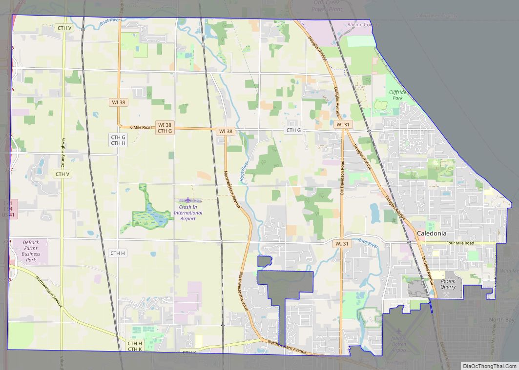
Map of Rhinelander city

Map of Rhinelander city

Rhinelander is a city in and the county seat of Oneida County, Wisconsin, United States. The population was 8,285 at the 2020 census. Rhinelander city overview: Name: Rhinelander city LSAD Code: 25 LSAD Description: city (suffix) State: Wisconsin County: Oneida County Elevation: 1,549 ft (472 m) Total Area: 8.68 sq mi (22.47 km²) Land Area: 8.42 sq mi (21.82 km²) Water Area: 0.25 sq mi … Read more

Map of Prairie Farm village

Map of Prairie Farm village

Prairie Farm is a town in Barron County in the U.S. state of Wisconsin. The population was 573 at the 2010 census. The village of Prairie Farm is surrounded by the town. Prairie Farm village overview: Name: Prairie Farm village LSAD Code: 47 LSAD Description: village (suffix) State: Wisconsin County: Barron County FIPS code: 5565150 … Read more

Map of Rewey village

Map of Rewey village

Rewey is a village in Iowa County, Wisconsin, United States. The population was 292 at the 2010 census. It is part of the Madison Metropolitan Statistical Area. Rewey village overview: Name: Rewey village LSAD Code: 47 LSAD Description: village (suffix) State: Wisconsin County: Iowa County Elevation: 1,129 ft (344 m) Total Area: 0.51 sq mi (1.31 km²) Land Area: 0.51 sq mi … Read more

Map of Prairie du Sac village

Map of Prairie du Sac village

Prairie du Sac is a village in Sauk County, Wisconsin, United States. The population was 4,420 at the 2020 census. The village is surrounded by the Town of Prairie du Sac, the Wisconsin River, and the village of Sauk City; together, Prairie du Sac and Sauk City are referred to as Sauk Prairie. Prairie du … Read more

Map of Reserve CDP, Wisconsin

Map of Reserve CDP, Wisconsin

Reserve is a census-designated place (CDP) in the Town of Couderay, Sawyer County, Wisconsin, United States. The population was 429 at the 2010 census. Reserve CDP overview: Name: Reserve CDP LSAD Code: 57 LSAD Description: CDP (suffix) State: Wisconsin County: Sawyer County Elevation: 1,306 ft (398 m) Total Area: 53.7 sq mi (139.1 km²) Land Area: 53.0 sq mi (137.3 km²) Water Area: … Read more

Map of Prairie du Chien city

Map of Prairie du Chien city

Prairie du Chien (/ˌprɛri du ˈʃiːn/) is a city in and the county seat of Crawford County, Wisconsin, United States. The population was 5,506 at the 2020 census. Its ZIP Code is 53821. Often called Wisconsin’s second-oldest city, Prairie du Chien was established as a European settlement by French voyageurs in the late 17th century. … Read more

Map of Reeseville village

Map of Reeseville village

Reeseville is a village in Dodge County, Wisconsin, United States. The population was 763 at the 2020 census. Reeseville village overview: Name: Reeseville village LSAD Code: 47 LSAD Description: village (suffix) State: Wisconsin County: Dodge County Elevation: 824 ft (251 m) Total Area: 0.63 sq mi (1.62 km²) Land Area: 0.63 sq mi (1.62 km²) Water Area: 0.00 sq mi (0.00 km²) Total Population: 763 Population … Read more

Map of Reedsville village, Wisconsin

Map of Reedsville village, Wisconsin

Reedsville is a village in Manitowoc County, Wisconsin, United States. The population was 1,195 at the 2020 census. Reedsville village overview: Name: Reedsville village LSAD Code: 47 LSAD Description: village (suffix) State: Wisconsin County: Manitowoc County Elevation: 827 ft (252 m) Total Area: 1.22 sq mi (3.16 km²) Land Area: 1.22 sq mi (3.15 km²) Water Area: 0.00 sq mi (0.01 km²) Total Population: 1,195 Population … Read more

Map of Reedsburg city

Map of Reedsburg city

Reedsburg is a city in Sauk County, Wisconsin, United States. Located along the Baraboo River, it was founded in 1868, and was named for early settler David C. Reed. The city is surrounded by the Town of Reedsburg. It is part of the Baraboo Micropolitan Statistical Area. Reedsburg city overview: Name: Reedsburg city LSAD Code: … Read more

Map of Redgranite village

Map of Redgranite village

Redgranite is a village in Waushara County, Wisconsin, United States. The population was 2,149 at the 2010 census. Redgranite village overview: Name: Redgranite village LSAD Code: 47 LSAD Description: village (suffix) State: Wisconsin County: Waushara County Elevation: 791 ft (241 m) Total Area: 2.37 sq mi (6.15 km²) Land Area: 2.36 sq mi (6.12 km²) Water Area: 0.01 sq mi (0.03 km²) Total Population: 2,149 Population … Read more

Map of Readstown village

Map of Readstown village

Readstown is a village in Vernon County, Wisconsin, United States. The population was 415 at the 2010 census. Readstown village overview: Name: Readstown village LSAD Code: 47 LSAD Description: village (suffix) State: Wisconsin County: Vernon County Elevation: 761 ft (232 m) Total Area: 1.73 sq mi (4.49 km²) Land Area: 1.71 sq mi (4.43 km²) Water Area: 0.02 sq mi (0.05 km²) Total Population: 415 Population … Read more

Map of Random Lake village

Map of Random Lake village

Random Lake is a village in Sheboygan County, Wisconsin, United States. The population was 1,594 at the 2010 census. It is part of the Sheboygan, Wisconsin Metropolitan Statistical Area. Random Lake village overview: Name: Random Lake village LSAD Code: 47 LSAD Description: village (suffix) State: Wisconsin County: Sheboygan County Elevation: 889 ft (271 m) Total Area: 1.76 sq mi … Read more