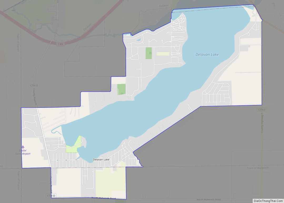
Map of Sheboygan Falls city

Map of Sheboygan Falls city

Sheboygan Falls is a city in Sheboygan County, Wisconsin, United States. Its population was 8,210 at the 2020 census. The city’s downtown is listed on the National Register of Historic Places and is the first Main Street Community in Wisconsin. The city is part of the Sheboygan, Wisconsin Metropolitan Statistical Area. Sheboygan Falls city overview: … Read more

Map of Shawano city

Map of Shawano city

Shawano (pronounced SHAW-no) is a city in Shawano County, Wisconsin, United States. The population was 9,305 at the 2010 census. It is the county seat of Shawano County. Shawano city overview: Name: Shawano city LSAD Code: 25 LSAD Description: city (suffix) State: Wisconsin County: Shawano County Elevation: 817 ft (249 m) Total Area: 6.94 sq mi (17.96 km²) Land Area: … Read more

Map of Sharon village, Wisconsin

Map of Sharon village, Wisconsin

Sharon is a village in Walworth County, Wisconsin, United States. The population was 1,586 at the 2020 census. The village is adjacent to the Town of Sharon. Sharon village overview: Name: Sharon village LSAD Code: 47 LSAD Description: village (suffix) State: Wisconsin County: Walworth County Total Area: 1.73 sq mi (4.47 km²) Land Area: 1.73 sq mi (4.47 km²) Water Area: … Read more

Map of Seymour CDP, Wisconsin

Map of Seymour CDP, Wisconsin

Seymour is a census-designated place (CDP) in Eau Claire County, Wisconsin, United States. The population was 1,418 at the 2010 census. It is located within the town of Seymour and is part of the Eau Claire urban area. Seymour CDP overview: Name: Seymour CDP LSAD Code: 57 LSAD Description: CDP (suffix) State: Wisconsin County: Eau … Read more

Map of Sextonville CDP

Map of Sextonville CDP

Sextonville is an unincorporated census-designated place located in the town of Buena Vista in Richland County, Wisconsin, United States. Sextonville is located on U.S. Route 14 southeast of Richland Center. Sextonville has a post office with ZIP code 53584. As of the 2020 census, its population was 476. Sextonville CDP overview: Name: Sextonville CDP LSAD … Read more

Map of St. Croix Falls city

Map of St. Croix Falls city

St. Croix Falls is a city in Polk County, Wisconsin, United States. The population was 2,208 at the 2020 census. The city is located within the Town of St. Croix Falls. U.S. Route 8, Wisconsin Highway 35, and Wisconsin Highway 87 are three of the main arterial routes in the city. St. Croix Falls city … Read more

Map of Slinger village

Map of Slinger village

Slinger (formerly Schleisingerville) is a village in Washington County, Wisconsin, United States. The population was 5,992 at the 2020 census. Slinger village overview: Name: Slinger village LSAD Code: 47 LSAD Description: village (suffix) State: Wisconsin County: Washington County Incorporated: 1869; 154 years ago (1869) Elevation: 1,063 ft (324 m) Total Area: 5.26 sq mi (13.63 km²) Land Area: 5.24 sq mi (13.57 km²) Water Area: … Read more

Map of St. Cloud village, Wisconsin

Map of St. Cloud village, Wisconsin

St. Cloud village overview: Name: St. Cloud village LSAD Code: 47 LSAD Description: village (suffix) State: Wisconsin County: Fond du Lac County FIPS code: 5570500 Online Interactive Map St. Cloud online map. Source: Basemap layers from Google Map, Open Street Map (OSM), Arcgisonline, Wmflabs. Boundary Data from Database of Global Administrative Areas. St. Cloud location … Read more

Map of Sister Bay village

Map of Sister Bay village

Sister Bay is a village in Door County, Wisconsin, United States. The population was 876 at the 2010 census. Sister Bay village overview: Name: Sister Bay village LSAD Code: 47 LSAD Description: village (suffix) State: Wisconsin County: Door County Elevation: 620 ft (189 m) Total Area: 3.57 sq mi (9.25 km²) Land Area: 2.58 sq mi (6.68 km²) Water Area: 0.99 sq mi (2.57 km²) Total … Read more

Map of Springfield CDP, Wisconsin

Map of Springfield CDP, Wisconsin

Springfield is an unincorporated community and census-designated place in the town of Lyons, in Walworth County, Wisconsin, United States. As of the 2020 census, its population was 168. Located just northeast of Lake Geneva, it contains a mere eight streets. Springfield has an area of 0.673 square miles (1.74 km), all of it land. Springfield CDP … Read more

Map of Siren village

Map of Siren village

Siren is a town in Burnett County in the U.S. state of Wisconsin. The population was 936 at the 2010 census. The village of Siren is located within the town. Siren village overview: Name: Siren village LSAD Code: 47 LSAD Description: village (suffix) State: Wisconsin County: Burnett County FIPS code: 5574175 Online Interactive Map Siren … Read more

Map of Springbrook CDP, Wisconsin

Map of Springbrook CDP, Wisconsin

Springbrook is an unincorporated community and census-designated place located in the town of Springbrook, Washburn County, Wisconsin, United States. Springbrook is located on U.S. Route 63 13 miles (21 km) northeast of Spooner. Springbrook has a post office with ZIP code 54875. Its population was 76 in 2017. Springbrook CDP overview: Name: Springbrook CDP LSAD Code: … Read more