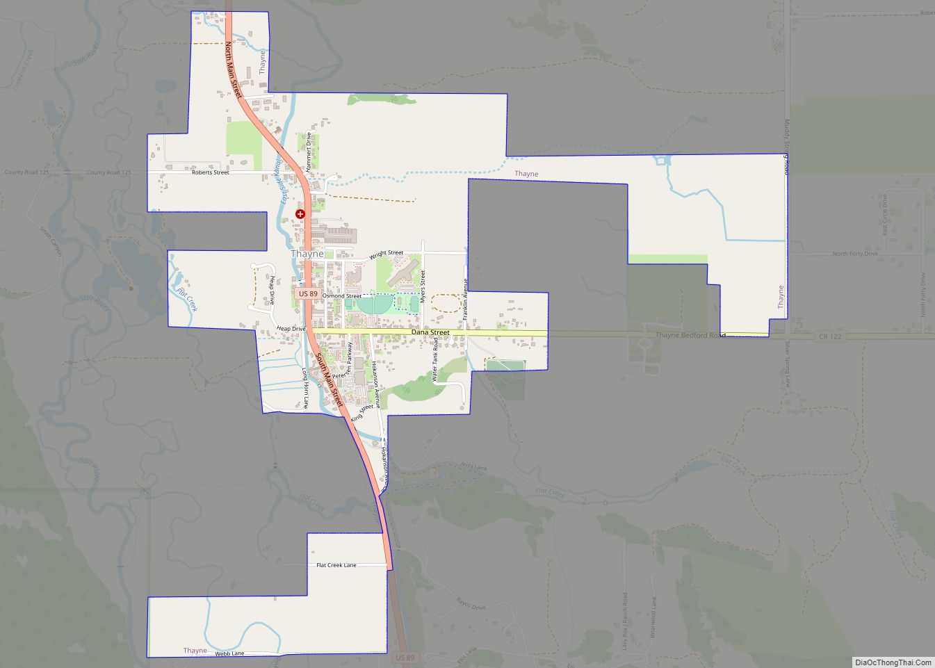
Map of Riverside town, Wyoming

Map of Riverside town, Wyoming

Riverside is a town in Carbon County, Wyoming, United States. The population was 52 at the 2010 census. Riverside town overview: Name: Riverside town LSAD Code: 43 LSAD Description: town (suffix) State: Wyoming County: Carbon County Elevation: 7,142 ft (2,177 m) Total Area: 0.27 sq mi (0.70 km²) Land Area: 0.27 sq mi (0.70 km²) Water Area: 0.00 sq mi (0.00 km²) Total Population: 52 Population … Read more

Map of Parkman CDP, Wyoming

Map of Parkman CDP, Wyoming

Parkman is a census-designated place (CDP) in Sheridan County, Wyoming, United States. The population was 180 at the 2020 census. Parkman CDP overview: Name: Parkman CDP LSAD Code: 57 LSAD Description: CDP (suffix) State: Wyoming County: Sheridan County Elevation: 4,305 ft (1,312 m) Total Area: 9.6 sq mi (25 km²) Land Area: 9.6 sq mi (25 km²) Water Area: 0.02 sq mi (0.05 km²) Total Population: … Read more

Map of Reliance CDP, Wyoming

Map of Reliance CDP, Wyoming

Reliance is a census-designated place (CDP) in Sweetwater County, Wyoming, United States. The population was 714 at the 2010 census. Reliance CDP overview: Name: Reliance CDP LSAD Code: 57 LSAD Description: CDP (suffix) State: Wyoming County: Sweetwater County Elevation: 6,529 ft (1,990 m) Total Area: 4.1 sq mi (11 km²) Land Area: 4.1 sq mi (11 km²) Water Area: 0.0 sq mi (0 km²) Total Population: … Read more

Map of Owl Creek CDP

Map of Owl Creek CDP

Owl Creek is a (CDP) in Hot Springs County, Wyoming, United States. The population was five at the 2010 Census. Owl Creek CDP overview: Name: Owl Creek CDP LSAD Code: 57 LSAD Description: CDP (suffix) State: Wyoming County: Hot Springs County Elevation: 5,647 ft (1,721 m) Total Area: 6.5 sq mi (16.8 km²) Land Area: 6.5 sq mi (16.8 km²) Water Area: 0.0 sq mi … Read more

Map of Red Butte CDP

Map of Red Butte CDP

Red Butte is a census-designated place (CDP) in Natrona County, Wyoming, United States. It is part of the Casper, Wyoming Metropolitan Statistical Area. The population was 1,430 at the 2020 census. Red Butte CDP overview: Name: Red Butte CDP LSAD Code: 57 LSAD Description: CDP (suffix) State: Wyoming County: Natrona County Elevation: 5,167 ft (1,575 m) Total … Read more

Map of Smoot CDP

Map of Smoot CDP

Smoot is a census-designated place (CDP) in Lincoln County, Wyoming, United States. The population was 195 at the 2010 census. Smoot CDP overview: Name: Smoot CDP LSAD Code: 57 LSAD Description: CDP (suffix) State: Wyoming County: Lincoln County Elevation: 6,611 ft (2,015 m) Total Area: 1.7 sq mi (4.4 km²) Land Area: 1.7 sq mi (4.4 km²) Water Area: 0.0 sq mi (0.0 km²) Total Population: … Read more

Map of Sleepy Hollow CDP, Wyoming

Map of Sleepy Hollow CDP, Wyoming

Sleepy Hollow is a census-designated place (CDP) in Campbell County, Wyoming, United States. The population was 1,308 at the 2010 census. Sleepy Hollow CDP overview: Name: Sleepy Hollow CDP LSAD Code: 57 LSAD Description: CDP (suffix) State: Wyoming County: Campbell County Elevation: 4,561 ft (1,390 m) Total Area: 0.42 sq mi (1.08 km²) Land Area: 0.42 sq mi (1.08 km²) Water Area: 0.0 sq mi … Read more

Map of Slater CDP, Wyoming

Map of Slater CDP, Wyoming

Slater is a census-designated place (CDP) in Platte County, Wyoming, United States. The population was 80 at the 2010 census. Slater CDP overview: Name: Slater CDP LSAD Code: 57 LSAD Description: CDP (suffix) State: Wyoming County: Platte County Elevation: 4,997 ft (1,523 m) Total Area: 74.0 sq mi (191.6 km²) Land Area: 74.0 sq mi (191.6 km²) Water Area: 0.0 sq mi (0.0 km²) Total Population: … Read more

Map of Sinclair town

Map of Sinclair town

Sinclair is a town in Carbon County, Wyoming, United States. Sinclair town overview: Name: Sinclair town LSAD Code: 43 LSAD Description: town (suffix) State: Wyoming County: Carbon County Elevation: 6,588 ft (2,008 m) Total Area: 2.43 sq mi (6.30 km²) Land Area: 2.43 sq mi (6.30 km²) Water Area: 0.00 sq mi (0.00 km²) Total Population: 433 Population Density: 162.48/sq mi (62.73/km²) ZIP code: 82334 Area code: … Read more

Map of Shoshoni town

Map of Shoshoni town

Shoshoni is a town in Fremont County, Wyoming, United States. The population was 471 at the 2020 census, down from 649 at the 2010 census. The town is named for the Shoshone Indian tribe, most of whom live on the nearby Wind River Indian Reservation. Shoshoni town overview: Name: Shoshoni town LSAD Code: 43 LSAD … Read more

Map of Sheridan city, Wyoming

Map of Sheridan city, Wyoming

Sheridan is a town in the U.S. state of Wyoming and the county seat of Sheridan County. The town is located halfway between Yellowstone Park and Mount Rushmore by U.S. Route 14 and 16. It is the principal town of the Sheridan, Wyoming, Micropolitan Statistical Area which encompasses all of Sheridan County. The 2010 census … Read more

Map of Shell CDP

Map of Shell CDP

Shell is a census-designated place (CDP) in Big Horn County, Wyoming, United States. The population was 83 at the 2010 Census. The community is named for the abundance of fossil shells located in the area. Nearby exposed formations such as the Cloverly Formation and the Morrison Formation have yielded numerous fossils of dinosaurs and other … Read more