Map of Red Level town

Map of Red Level town

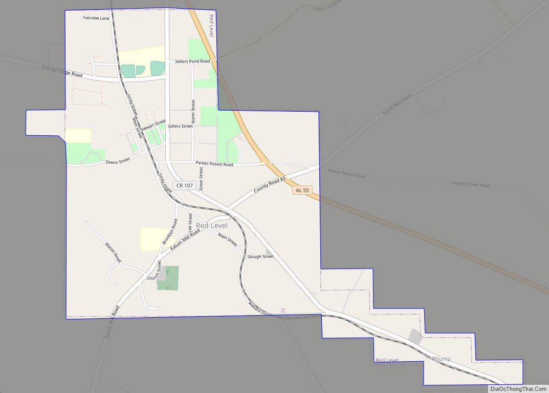
Red Level is a town in Covington County, Alabama, United States. At the 2020 census, the population was 432. Red Level town overview: Name: Red Level town LSAD Code: 43 LSAD Description: town (suffix) State: Alabama County: Covington County Elevation: 354 ft (108 m) Total Area: 1.93 sq mi (4.99 km²) Land Area: 1.92 sq mi (4.98 km²) Water Area: 0.01 sq mi (0.01 km²) Total … Read more

Map of Red Bay city

Map of Red Bay city

Red Bay is a city in Franklin County, Alabama, United States. It was founded in 1907; its western boundary line is integral with the state line between Mississippi and Alabama. The population was 3,232 at the 2020 census. The town’s name comes from the area’s red clay soil and the many redbay trees (Persea borbonia) … Read more

Map of Ray CDP

Map of Ray CDP, Alabama

Ray is a census-designated place and unincorporated community in Coosa County, Alabama, United States. Its population was 326 as of the 2020 census. Ray CDP overview: Name: Ray CDP LSAD Code: 57 LSAD Description: CDP (suffix) State: Alabama County: Coosa County Elevation: 732 ft (223 m) Total Area: 9.51 sq mi (24.64 km²) Land Area: 9.46 sq mi (24.51 km²) Water Area: 0.05 sq mi … Read more

Map of Reece City town

Map of Reece City town

Reece City is a town in Etowah County, Alabama, United States. It was incorporated in May 1956. It is part of the Gadsden Metropolitan Statistical Area. At the 2020 census, the population was 615. Reece City town overview: Name: Reece City town LSAD Code: 43 LSAD Description: town (suffix) State: Alabama County: Etowah County Elevation: … Read more

Map of Redstone Arsenal CDP

Map of Redstone Arsenal CDP

Redstone Arsenal (RSA) is a United States Army post and a census-designated place (CDP) adjacent to Huntsville in Madison County, Alabama, United States and is part of the Huntsville-Decatur Combined Statistical Area. The Arsenal is a garrison for various tenants across the Department of Defense, Department of Justice, and NASA. RSA has benefited from decisions … Read more

Map of Redland CDP

Map of Redland CDP, Alabama

Redland is a census-designated place in Elmore County, Alabama, United States. Its population was 3,736 as of the 2010 census. Redland CDP overview: Name: Redland CDP LSAD Code: 57 LSAD Description: CDP (suffix) State: Alabama County: Elmore County Elevation: 433 ft (132 m) Total Area: 24.43 sq mi (63.26 km²) Land Area: 24.13 sq mi (62.49 km²) Water Area: 0.30 sq mi (0.77 km²) Total Population: … Read more

Map of Rehobeth town

Map of Rehobeth town

Rehobeth is a town in Houston County, Alabama, United States. Rehobeth, originally named Sanders, began as a crossroads community in the 1890s; however, it was not until 1996, that the town was incorporated. Rehobeth is part of the Dothan Metropolitan Statistical Area. At the time of the 2010 census, the population was 1,297, up from … Read more

Map of Reform town

Map of Reform town

Reform is a city in Pickens County, Alabama, United States. At the 2010 census the population was 1,702, down from 1,978 in 2000. It is located approximately halfway between Columbus, Mississippi and Tuscaloosa on U.S. Route 82. Reform town overview: Name: Reform town LSAD Code: 43 LSAD Description: town (suffix) State: Alabama County: Pickens County … Read more

Map of Reeltown CDP

Map of Reeltown CDP

Reeltown is a census-designated place and unincorporated community in Tallapoosa County, Alabama, United States. Its population was 766 as of the 2010 census. The “Reel” in Reeltown is a misspelling of “Real” from the last name of settlers James Patrick and Phillip O’Real. The town was called Thaddeus from 1880 to 1902 in honor of … Read more

Map of River Falls town

Map of River Falls town, Alabama

River Falls is a town in Covington County, Alabama, United States. At the 2020 census, the population was 479. River Falls town overview: Name: River Falls town LSAD Code: 43 LSAD Description: town (suffix) State: Alabama County: Covington County Elevation: 200 ft (61 m) Total Area: 7.10 sq mi (18.38 km²) Land Area: 6.83 sq mi (17.70 km²) Water Area: 0.26 sq mi (0.68 km²) Total … Read more

Map of Ridgeville town

Map of Ridgeville town, Alabama

Ridgeville is a town in Etowah County, Alabama, United States. It incorporated in 1969 and is part of the Gadsden Metropolitan Statistical Area. At the 2020 census the population was 83, down from 158 in 2000. It is noteworthy for being the only community in Etowah County to have a black majority. Since 1970, it … Read more

Map of Repton town

Map of Repton town

Repton is a town in Conecuh County, Alabama, United States. It was incorporated on January 10, 1899. At the 2020 census, the population was 235. Repton town overview: Name: Repton town LSAD Code: 43 LSAD Description: town (suffix) State: Alabama County: Conecuh County Elevation: 351 ft (107 m) Total Area: 0.96 sq mi (2.50 km²) Land Area: 0.96 sq mi (2.48 km²) Water … Read more