Map of Etowah town

Map of Etowah town, Arkansas

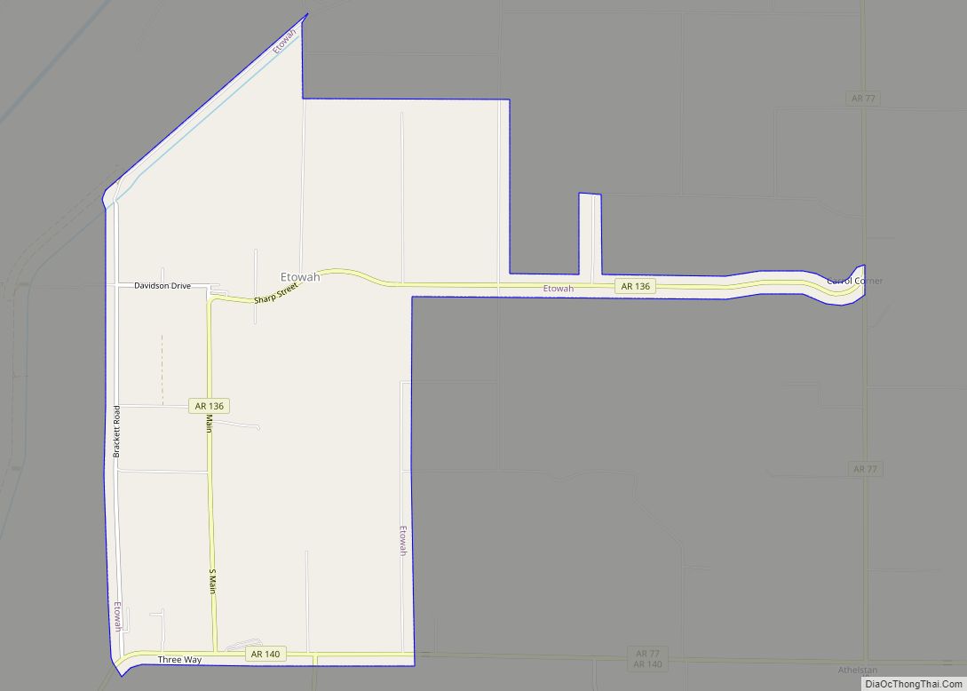
Etowah is a town in Mississippi County, Arkansas, United States. The population was 254 at the 2020 census, down from 351 in 2010. Etowah town overview: Name: Etowah town LSAD Code: 43 LSAD Description: town (suffix) State: Arkansas County: Mississippi County Elevation: 230 ft (70 m) Total Area: 5.94 sq mi (15.39 km²) Land Area: 5.94 sq mi (15.38 km²) Water Area: 0.01 sq mi … Read more

Map of Enola town

Map of Enola town, Arkansas

Enola is a town in Faulkner County, Arkansas, United States. It is part of the Little Rock–North Little Rock–Conway Metropolitan Statistical Area. The population was 338 at the 2010 census, up from 188 at the 2000 census. Enola town overview: Name: Enola town LSAD Code: 43 LSAD Description: town (suffix) State: Arkansas County: Faulkner County … Read more

Map of Everton town

Map of Everton town, Arkansas

Everton is a town in Boone County, Arkansas, United States. The population was 133 at the 2010 census. It is part of the Harrison Micropolitan Statistical Area. Everton town overview: Name: Everton town LSAD Code: 43 LSAD Description: town (suffix) State: Arkansas County: Boone County Elevation: 860 ft (262 m) Total Area: 0.47 sq mi (1.23 km²) Land Area: 0.47 sq mi … Read more

Map of Evening Shade city

Map of Evening Shade city, Arkansas

Evening Shade is a city in southwest Sharp County, Arkansas, United States. The population was down to 428 in 2021 and a strong EF2 tornado struck the north town on March 6, 2022, impacting 2 houses. Evening Shade city overview: Name: Evening Shade city LSAD Code: 25 LSAD Description: city (suffix) State: Arkansas County: Sharp … Read more

Map of Eureka Springs city

Map of Eureka Springs city

Eureka Springs is a city in Carroll County, Arkansas, United States, and one of two county seats for the county. It is located in the Ozark Mountains of northwest Arkansas, near the border with Missouri. As of the 2020 census, the city population was 2,166. In 1970 the entire city, as of its borders at … Read more

Map of Farmington city

Map of Farmington city, Arkansas

Farmington is a city in Washington County, Arkansas, United States. The community is nestled in a valley among the Boston Mountains, a subset of the Ozark Mountains. Although the first settlers came from the Deep South in 1828, the community did not incorporate until 1946. Located immediately west of Fayetteville in the Northwest Arkansas metropolitan … Read more

Map of Fargo city

Map of Fargo town, Arkansas

Fargo is a town in Monroe County, Arkansas, United States. As of the 2020 United States census it had a population of 57, down from 98 in 2010. Fargo town overview: Name: Fargo town LSAD Code: 43 LSAD Description: town (suffix) State: Arkansas County: Monroe County Elevation: 200 ft (60 m) Total Area: 0.47 sq mi (1.23 km²) Land Area: … Read more

Map of Fairfield Bay city

Map of Fairfield Bay city

Fairfield Bay is a city in Cleburne and Van Buren counties in the northern part of the U.S. state of Arkansas. The population was 2,108 at the 2020 census. The population in its portion in Van Buren County, which accounts for the bulk of the city limits, made the city the most populous in Van … Read more

Map of Fifty-Six city

Map of Fifty-Six city

Fifty-Six is an incorporated town in Stone County, Arkansas, United States. As of the 2020 census, the city had a total population of 158, a decrease of 15 people from 2010. Fifty-Six city overview: Name: Fifty-Six city LSAD Code: 25 LSAD Description: city (suffix) State: Arkansas County: Stone County Elevation: 889 ft (271 m) Total Area: 2.07 sq mi … Read more

Map of Felsenthal town

Map of Felsenthal town

Felsenthal is a town in Union County, Arkansas, United States. The population was 152 at the 2000 census and 150 at the 2010 census. It lays right on the Ouachita River in the southeastern corner of Union County. The small community attracts tourists from all over the state for the fishing and waterfowl hunting in … Read more

Map of Fisher city

Map of Fisher city, Arkansas

Fisher is a city in Poinsett County, Arkansas, United States. The population was 223 at the 2010 census. It is included in the Jonesboro, Arkansas Metropolitan Statistical Area. Fisher city overview: Name: Fisher city LSAD Code: 25 LSAD Description: city (suffix) State: Arkansas County: Poinsett County Elevation: 233 ft (71 m) Total Area: 0.30 sq mi (0.77 km²) Land Area: … Read more

Map of Foreman city

Map of Foreman city

Foreman is a small city in Little River County, Arkansas, United States. The population was 1,011 at the 2010 census. Foreman city overview: Name: Foreman city LSAD Code: 25 LSAD Description: city (suffix) State: Arkansas County: Little River County Elevation: 417 ft (127 m) Total Area: 1.99 sq mi (5.15 km²) Land Area: 1.98 sq mi (5.12 km²) Water Area: 0.01 sq mi (0.03 km²) Total … Read more