Map of Goshen town, Arkansas

Map of Goshen town, Arkansas

Goshen is a city in Washington County, Arkansas, United States. The population was 2,102 at the 2020 census. It is part of the Northwest Arkansas region. According to Business Insider, it is the “most educated” city in the state of Arkansas (September 10, 2014). Goshen town overview: Name: Goshen town LSAD Code: 43 LSAD Description: … Read more

Map of Glenwood city, Arkansas

Map of Glenwood city, Arkansas

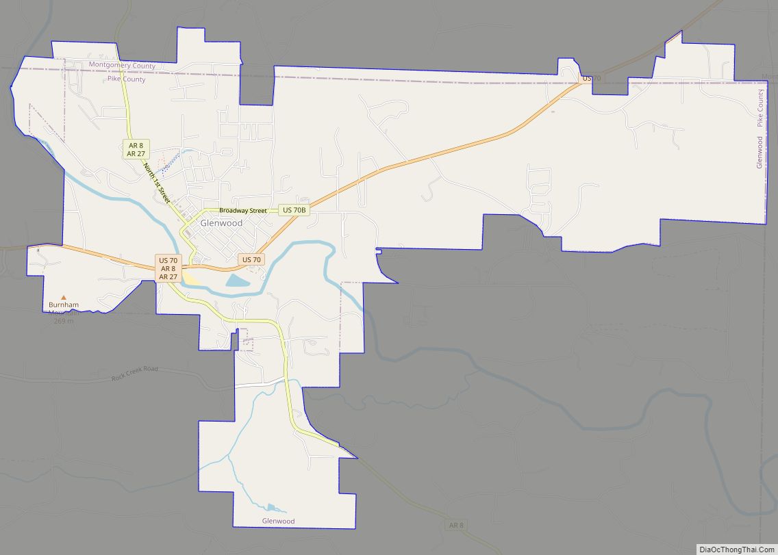
Glenwood is a city in Pike and Montgomery counties in Arkansas, United States. As of the 2020 census, its population was 2,068. The community is located along the Caddo River in the Ouachita Mountains. Glenwood was formed as a boomtown following the development of the Gurdon and Fort Smith Railroad and timber interests in the … Read more

Map of Grannis city

Map of Grannis city

Grannis is a city in Polk County, Arkansas, United States. The population was 554 at the 2010 census. Near Grannis is the Boggs Springs Youth Encampment of the American Baptist Association, a retreat of Missionary Baptist churches. Grannis city overview: Name: Grannis city LSAD Code: 25 LSAD Description: city (suffix) State: Arkansas County: Polk County … Read more

Map of Grady city

Map of Grady city, Arkansas

Grady is a city in Lincoln County, Arkansas, United States. The population was 449 at the 2010 census, down from 523 at the 2000 census. It is included in the Pine Bluff, Arkansas Metropolitan Statistical Area. Grady city overview: Name: Grady city LSAD Code: 25 LSAD Description: city (suffix) State: Arkansas County: Lincoln County Elevation: … Read more

Map of Gould city

Map of Gould city, Arkansas

Gould is a city in Lincoln County, Arkansas, United States. Its population was 837 at the 2010 census, down from 1,305 at the 2000 census. It is included in the Pine Bluff, Arkansas Metropolitan Statistical Area. Gould is a farming community. It was named after the American railroad magnate Jay Gould. Gould city overview: Name: … Read more

Map of Gravette city

Map of Gravette city

Gravette /ˈɡrævɪt/ is a city in Benton County, Arkansas, United States. The population is 3,547 according to the 2020 census. The population was 3,547 as of the 2020 census. It is part of the Northwest Arkansas region. Gravette city overview: Name: Gravette city LSAD Code: 25 LSAD Description: city (suffix) State: Arkansas County: Benton County … Read more

Map of Greenbrier city

Map of Greenbrier city, Arkansas

Greenbrier is a city in Faulkner County, Arkansas, United States. It is part of the Little Rock–North Little Rock–Conway Metropolitan Statistical Area. The population was 5,707 at the 2020 census, up from 4,706 at the 2010 census. Greenbrier city overview: Name: Greenbrier city LSAD Code: 25 LSAD Description: city (suffix) State: Arkansas County: Faulkner County … Read more

Map of Green Forest city

Map of Green Forest city

Green Forest is a city in Carroll County, Arkansas, United States. The population was 2,972 at the 2020 census. Green Forest city overview: Name: Green Forest city LSAD Code: 25 LSAD Description: city (suffix) State: Arkansas County: Carroll County Elevation: 1,339 ft (408 m) Total Area: 2.46 sq mi (6.38 km²) Land Area: 2.46 sq mi (6.38 km²) Water Area: 0.00 sq mi (0.00 km²) Total … Read more

Map of Greenwood city

Map of Greenwood city, Arkansas

Greenwood is a city in and one of the two county seats of Sebastian County, Arkansas, United States. It is the fifth largest municipality in the Fort Smith, Arkansas–Oklahoma Metropolitan Statistical Area with a population of 8,952 according to the 2010 US Census. According to estimates based on the most recent census, the population of … Read more

Map of Greenway city

Map of Greenway city

Greenway is a city in eastern Clay County, Arkansas, United States. The population was 209 at the 2010 census. Greenway city overview: Name: Greenway city LSAD Code: 25 LSAD Description: city (suffix) State: Arkansas County: Clay County Elevation: 285 ft (87 m) Total Area: 0.26 sq mi (0.67 km²) Land Area: 0.26 sq mi (0.67 km²) Water Area: 0.00 sq mi (0.00 km²) Total Population: 174 … Read more

Map of Greenland city

Map of Greenland city

Greenland is a city in Washington County, Arkansas, United States. The population is 1,213 as of the 2020 census. The community is located in the Boston Mountains, within the Ozark Mountains. Greenland city overview: Name: Greenland city LSAD Code: 25 LSAD Description: city (suffix) State: Arkansas County: Washington County Elevation: 1,293 ft (394 m) Land Area: 4.01 sq mi … Read more

Map of Grubbs city

Map of Grubbs city

Grubbs is a city in Jackson County, Arkansas, United States. The population was 386 at the 2010 census. Grubbs city overview: Name: Grubbs city LSAD Code: 25 LSAD Description: city (suffix) State: Arkansas County: Jackson County Elevation: 230 ft (70 m) Total Area: 0.57 sq mi (1.47 km²) Land Area: 0.57 sq mi (1.47 km²) Water Area: 0.00 sq mi (0.00 km²) Total Population: 301 Population … Read more