Map of Griffithville town

Map of Griffithville town

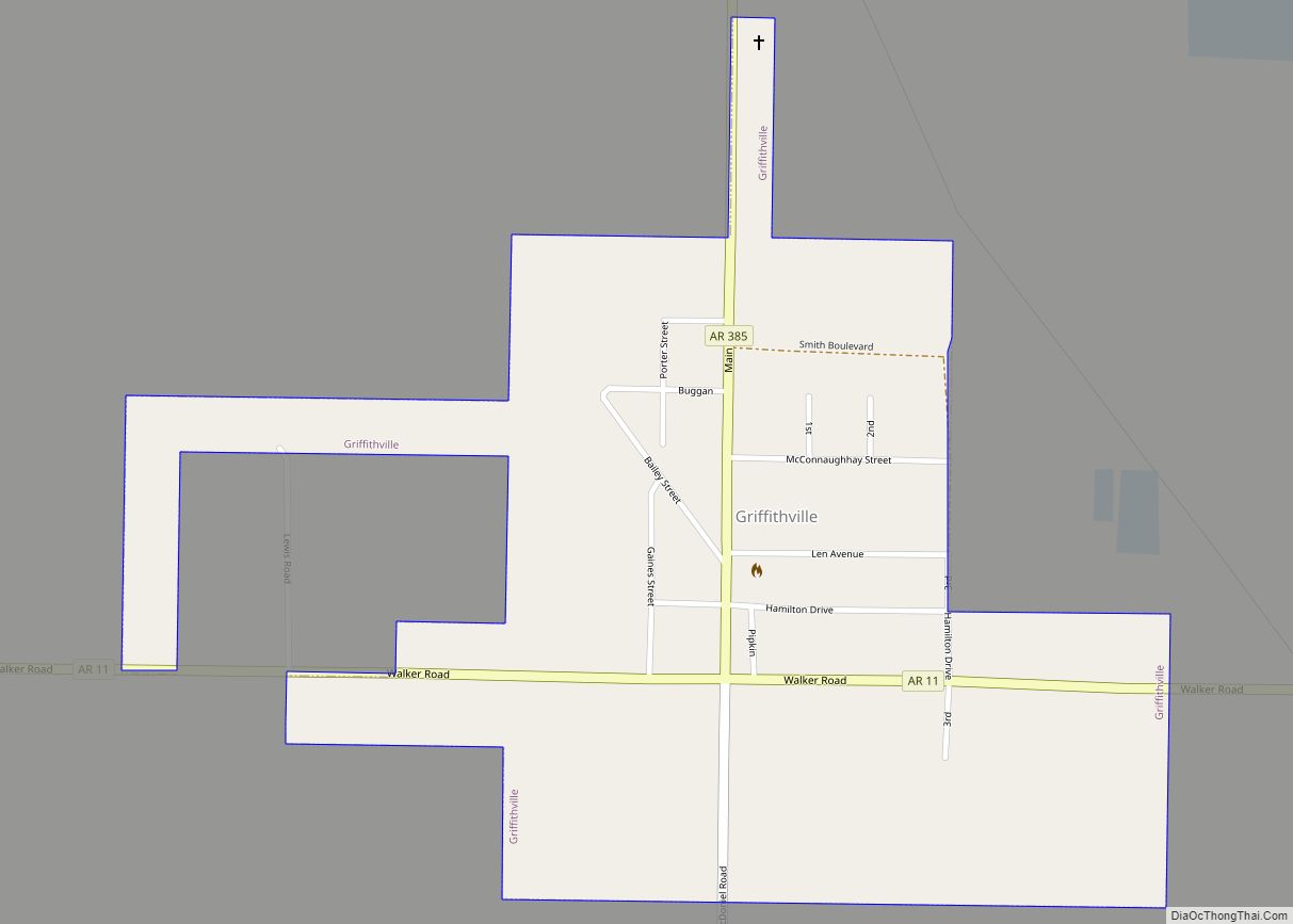
Griffithville is a town in White County, Arkansas, United States. Windle Porter is the current mayor. The population was 262 at the 2000 census. Griffithville town overview: Name: Griffithville town LSAD Code: 43 LSAD Description: town (suffix) State: Arkansas County: White County Elevation: 217 ft (66 m) Total Area: 0.55 sq mi (1.42 km²) Land Area: 0.55 sq mi (1.42 km²) Water Area: … Read more

Map of Greers Ferry city

Map of Greers Ferry city

Greers Ferry is a city in Cleburne County, Arkansas, United States. The population was 891 at the 2010 census. Greers Ferry city overview: Name: Greers Ferry city LSAD Code: 25 LSAD Description: city (suffix) State: Arkansas County: Cleburne County Elevation: 604 ft (184 m) Total Area: 7.23 sq mi (18.72 km²) Land Area: 7.22 sq mi (18.69 km²) Water Area: 0.01 sq mi (0.03 km²) Total … Read more

Map of Gurdon city

Map of Gurdon city

Gurdon is a city in Clark County, Arkansas, United States. The population was 2,212 at the 2010 census. Gurdon city overview: Name: Gurdon city LSAD Code: 25 LSAD Description: city (suffix) State: Arkansas County: Clark County Elevation: 203 ft (62 m) Total Area: 2.49 sq mi (6.46 km²) Land Area: 2.42 sq mi (6.28 km²) Water Area: 0.07 sq mi (0.18 km²) Total Population: 1,840 Population … Read more

Map of Gum Springs town

Map of Gum Springs town

Gum Springs is a town in Clark County, Arkansas, United States. The population was 120 at the 2010 census, down from 194 in 2000. Gum Springs town overview: Name: Gum Springs town LSAD Code: 43 LSAD Description: town (suffix) State: Arkansas County: Clark County Elevation: 210 ft (60 m) Total Area: 0.39 sq mi (1.01 km²) Land Area: 0.39 sq mi (1.01 km²) … Read more

Map of Guion town

Map of Guion town

Guion is a town in Izard County, Arkansas, United States. The population was 86 at the 2010 census. Guion town overview: Name: Guion town LSAD Code: 43 LSAD Description: town (suffix) State: Arkansas County: Izard County Elevation: 371 ft (113 m) Total Area: 0.56 sq mi (1.45 km²) Land Area: 0.56 sq mi (1.45 km²) Water Area: 0.00 sq mi (0.00 km²) Total Population: 68 Population … Read more

Map of Hagarville CDP

Map of Hagarville CDP

Hagarville is a census-designated place in Johnson County, Arkansas, United States. Per the 2020 census, the population was 142. Hagarville CDP overview: Name: Hagarville CDP LSAD Code: 57 LSAD Description: CDP (suffix) State: Arkansas County: Johnson County Elevation: 535 ft (163 m) Total Area: 4.16 sq mi (10.79 km²) Land Area: 4.14 sq mi (10.73 km²) Water Area: 0.02 sq mi (0.05 km²) Total Population: 142 … Read more

Map of Hackett city

Map of Hackett city

Hackett is a city in Sebastian County, Arkansas, United States. It is part of the Fort Smith, Arkansas–Oklahoma Metropolitan Statistical Area. The population was 812 at the 2010 census. Hackett city overview: Name: Hackett city LSAD Code: 25 LSAD Description: city (suffix) State: Arkansas County: Sebastian County Elevation: 538 ft (164 m) Total Area: 1.46 sq mi (3.79 km²) Land … Read more

Map of Guy city

Map of Guy city

Guy is a city in Faulkner County, Arkansas, United States. The population was 708 at the 2010 census, up from 202 at the 2000 census. It is part of the Little Rock–North Little Rock–Conway Metropolitan Statistical Area. Guy city overview: Name: Guy city LSAD Code: 25 LSAD Description: city (suffix) State: Arkansas County: Faulkner County … Read more

Map of Hardy city

Map of Hardy city, Arkansas

Hardy is the 2nd oldest city in Sharp and Fulton counties in the U.S. state of Arkansas. The population was 765 in 2020. Hardy city overview: Name: Hardy city LSAD Code: 25 LSAD Description: city (suffix) State: Arkansas County: Fulton County, Sharp County Elevation: 440 ft (130 m) Total Area: 5.31 sq mi (13.76 km²) Land Area: 5.06 sq mi (13.09 km²) Water … Read more

Map of Hampton city

Map of Hampton city, Arkansas

Hampton is a town in Calhoun County, Arkansas, United States. The population was 1,324 at the 2010 census. The town is the county seat of Calhoun County. Hampton is part of the Camden Micropolitan Statistical Area. Hampton city overview: Name: Hampton city LSAD Code: 25 LSAD Description: city (suffix) State: Arkansas County: Calhoun County Elevation: … Read more

Map of Hamburg city

Map of Hamburg city, Arkansas

Hamburg is a city and county seat of Ashley County, Arkansas, United States. The population was 2,857 at the 2010 census. It is best known for being the home town of NBA legend Scottie Pippen. Hamburg city overview: Name: Hamburg city LSAD Code: 25 LSAD Description: city (suffix) State: Arkansas County: Ashley County Elevation: 161 ft … Read more

Map of Harrison city

Map of Harrison city, Arkansas

Harrison is a city in and the county seat of Boone County, Arkansas, United States. It is named after Marcus LaRue Harrison, a surveyor who laid out the city along Crooked Creek at Stifler Springs. According to 2019 Census Bureau estimates, the population of the city was 13,069, up from 12,943 at the 2010 census … Read more