Map of Nimmons town

Map of Nimmons town

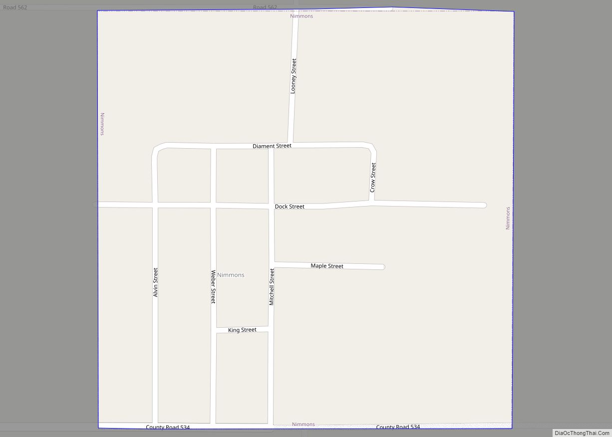
Nimmons is a town in Clay County, Arkansas, United States. The population was 69 at the 2010 census, down from 100 in 2000. Nimmons town overview: Name: Nimmons town LSAD Code: 43 LSAD Description: town (suffix) State: Arkansas County: Clay County Elevation: 269 ft (82 m) Total Area: 0.25 sq mi (0.65 km²) Land Area: 0.25 sq mi (0.65 km²) Water Area: 0.00 sq mi … Read more

Map of Newport city

Map of Newport city, Arkansas

Newport is a city in and the county seat of Jackson County, Arkansas, United States located on the White River 84 miles (135 km) northeast of Little Rock. The population was 7,879 at the 2010 census. Newport is home to a campus of the Arkansas State University system, with particular focus on training in transportation careers. … Read more

Map of North Crossett CDP

Map of North Crossett CDP

North Crossett is a census-designated place (CDP) in Ashley County, Arkansas, United States. Per the 2020 census, the population was 2,756. North Crossett CDP overview: Name: North Crossett CDP LSAD Code: 57 LSAD Description: CDP (suffix) State: Arkansas County: Ashley County Elevation: 151 ft (46 m) Total Area: 10.46 sq mi (27.09 km²) Land Area: 10.43 sq mi (27.02 km²) Water Area: 0.03 sq mi … Read more

Map of Norphlet city

Map of Norphlet city

Norphlet is a city in Union County, Arkansas, United States. As of the 2010 census the population stood at 844. Norphlet city overview: Name: Norphlet city LSAD Code: 25 LSAD Description: city (suffix) State: Arkansas County: Union County Elevation: 180 ft (55 m) Total Area: 2.04 sq mi (5.29 km²) Land Area: 2.04 sq mi (5.29 km²) Water Area: 0.00 sq mi (0.00 km²) Total Population: … Read more

Map of Norman city

Map of Norman town, Arkansas

Norman is a town in Montgomery County, Arkansas, United States. It was known as Womble until 1925. The population was 303 at the 2020 census, down from 378 in 2010. Norman town overview: Name: Norman town LSAD Code: 43 LSAD Description: town (suffix) State: Arkansas County: Montgomery County Elevation: 692 ft (211 m) Total Area: 1.14 sq mi (2.95 km²) … Read more

Map of O'Kean town

Map of O’Kean town

O’Kean is a town in Randolph County, Arkansas, United States. The population was 192 at the 2020 census. O’Kean town overview: Name: O’Kean town LSAD Code: 43 LSAD Description: town (suffix) State: Arkansas County: Randolph County Elevation: 269 ft (82 m) Total Area: 1.02 sq mi (2.64 km²) Land Area: 1.02 sq mi (2.64 km²) Water Area: 0.00 sq mi (0.00 km²) Total Population: 192 Population … Read more

Map of North Little Rock city

Map of North Little Rock city

North Little Rock is a city in Pulaski County, Arkansas, across the Arkansas River from Little Rock in the central part of the state. The population was 64,591 at the 2020 census. In 2019 the estimated population was 65,903, making it the seventh-most populous city in the state. North Little Rock, along with Little Rock … Read more

Map of Oak Grove Heights town

Map of Oak Grove Heights town

Oak Grove Heights is a city in Greene County, Arkansas, United States. The population was 889 at the 2010 census. Oak Grove Heights town overview: Name: Oak Grove Heights town LSAD Code: 43 LSAD Description: town (suffix) State: Arkansas County: Greene County Elevation: 335 ft (102 m) Total Area: 3.00 sq mi (7.77 km²) Land Area: 3.00 sq mi (7.76 km²) Water Area: … Read more

Map of Oden town

Map of Oden town, Arkansas

Oden is a town in Montgomery County, Arkansas, United States. As of the 2020 census, its population was 180, down from 232 in 2010. Oden town overview: Name: Oden town LSAD Code: 43 LSAD Description: town (suffix) State: Arkansas County: Montgomery County Elevation: 761 ft (232 m) Total Area: 0.84 sq mi (2.17 km²) Land Area: 0.81 sq mi (2.11 km²) Water Area: … Read more

Map of Oakhaven town

Map of Oakhaven town

Oakhaven is a town in Hempstead County, Arkansas, United States. The population was 63 at the 2010 census. It is part of the Hope Micropolitan Statistical Area. Oakhaven town overview: Name: Oakhaven town LSAD Code: 43 LSAD Description: town (suffix) State: Arkansas County: Hempstead County Elevation: 367 ft (112 m) Total Area: 0.05 sq mi (0.12 km²) Land Area: 0.05 sq mi … Read more

Map of Oak Grove town, Arkansas

Map of Oak Grove town, Arkansas

Oak Grove is a town in Carroll County, Arkansas, United States. The population was 386 at the 2020 census. Oak Grove town overview: Name: Oak Grove town LSAD Code: 43 LSAD Description: town (suffix) State: Arkansas County: Carroll County Elevation: 1,352 ft (412 m) Total Area: 2.76 sq mi (7.15 km²) Land Area: 2.76 sq mi (7.15 km²) Water Area: 0.00 sq mi (0.00 km²) Total … Read more

Map of Okolona town

Map of Okolona town, Arkansas

Okolona is a town near the western edge of Clark County, Arkansas, United States. The population was 147 at the 2010 census. The Battle of Elkin’s Ferry of the Civil War was fought here during April 3–4, 1864, as a part of the Camden Expedition. Union forces, led by Maj. Gen. Fred Steele, sought to … Read more