Map of Bull Shoals city

Map of Bull Shoals city

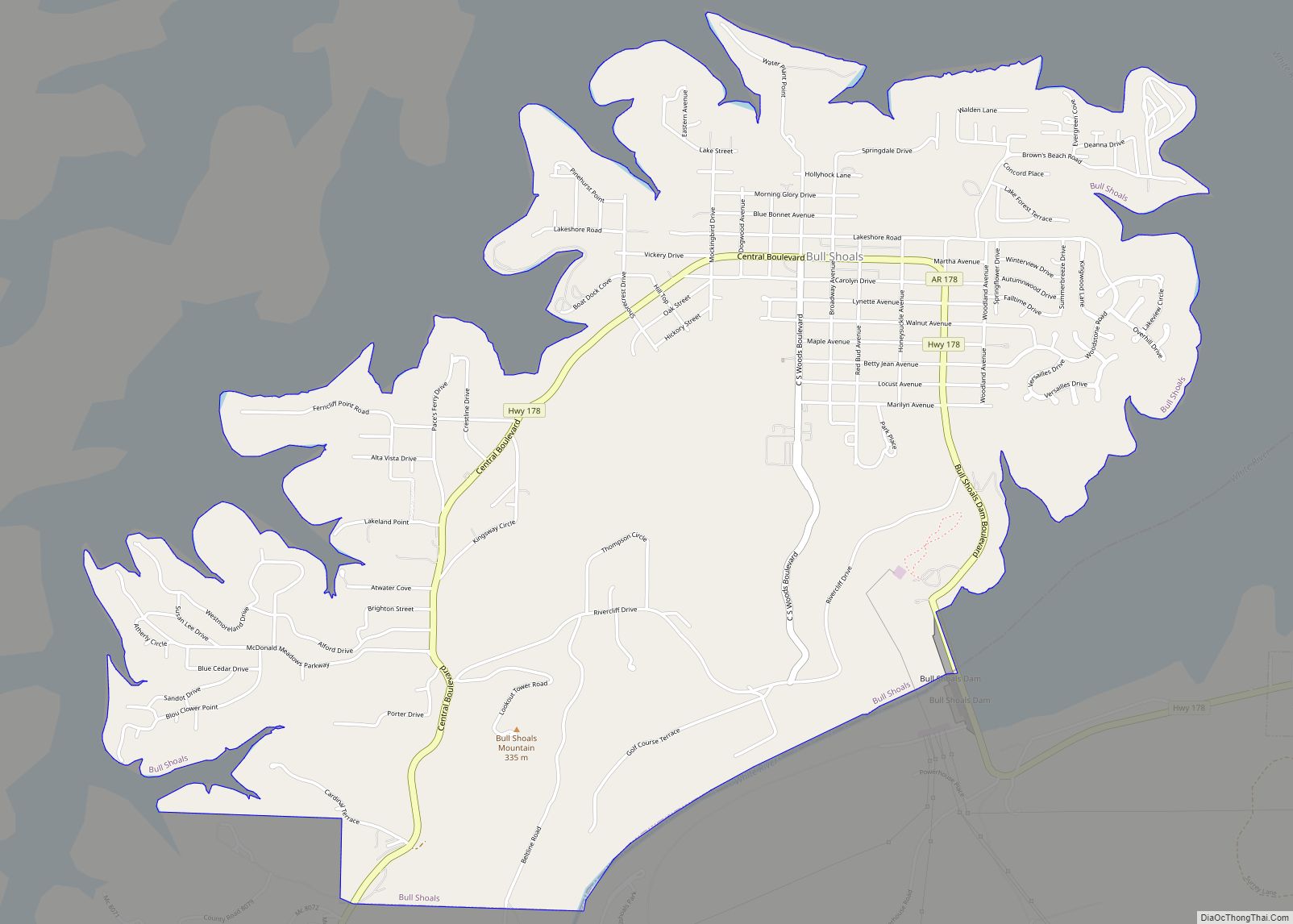
Bull Shoals is a city in Marion County, Arkansas, United States, founded in 1954. The population was 1,952 at the 2020 census. Primarily a retirement and vacation center, Bull Shoals is bordered in three directions by the clear, deep, man-made Bull Shoals Lake. Bull Shoals city overview: Name: Bull Shoals city LSAD Code: 25 LSAD … Read more

Map of Buckner city

Map of Buckner city, Arkansas

Buckner is a town in Lafayette County, Arkansas, United States. The population was 275 at the 2010 census. Buckner city overview: Name: Buckner city LSAD Code: 25 LSAD Description: city (suffix) State: Arkansas County: Lafayette County Elevation: 292 ft (89 m) Total Area: 1.18 sq mi (3.06 km²) Land Area: 1.18 sq mi (3.05 km²) Water Area: 0.01 sq mi (0.01 km²) Total Population: 165 Population … Read more

Map of Caldwell city

Map of Caldwell town, Arkansas

Caldwell is a town in St. Francis County, Arkansas, United States. The population was 555 at the 2010 census, an increase from 465 in 2000. Caldwell town overview: Name: Caldwell town LSAD Code: 43 LSAD Description: town (suffix) State: Arkansas County: St. Francis County Elevation: 236 ft (73 m) Land Area: 3.19 sq mi (8.25 km²) Water Area: 0.02 sq mi (0.05 km²) … Read more

Map of Caddo Valley town

Map of Caddo Valley town

Caddo Valley is a town in Clark County, Arkansas, United States. The population was 635 at the 2010 census. Caddo Valley town overview: Name: Caddo Valley town LSAD Code: 43 LSAD Description: town (suffix) State: Arkansas County: Clark County Elevation: 210 ft (60 m) Total Area: 3.11 sq mi (8.06 km²) Land Area: 3.10 sq mi (8.02 km²) Water Area: 0.01 sq mi (0.03 km²) Total … Read more

Map of Cabot city

Map of Cabot city, Arkansas

Cabot is the largest city in Lonoke County, Arkansas, United States, and a suburb of Little Rock. As of the 2010 census, the population of the city was 23,776, and in 2019 the population was an estimated 26,352, ranking it as the state’s 19th largest city, behind Jacksonville. It is part of the Little Rock–North … Read more

Map of Calion city

Map of Calion city

Calion is a second-class city in Union County, Arkansas, United States. The population was 494 at the 2010 census. Calion city overview: Name: Calion city LSAD Code: 25 LSAD Description: city (suffix) State: Arkansas County: Union County Elevation: 89 ft (27 m) Total Area: 1.30 sq mi (3.38 km²) Land Area: 1.07 sq mi (2.78 km²) Water Area: 0.23 sq mi (0.60 km²) Total Population: 429 … Read more

Map of Calico Rock city

Map of Calico Rock city

Calico Rock is a city in Izard County, Arkansas, United States. The population was 1,545 at the 2010 census, up from 991 in 2000. Calico Rock city overview: Name: Calico Rock city LSAD Code: 25 LSAD Description: city (suffix) State: Arkansas County: Izard County Incorporated: 1905 Elevation: 587 ft (179 m) Total Area: 4.81 sq mi (12.47 km²) Land Area: … Read more

Map of Cale town

Map of Cale town

Cale is a town in Nevada County, Arkansas, United States. The population was 75 at the 2000 census. It is part of the Hope Micropolitan Statistical Area. The town was named after Cale Wardell. Cale town overview: Name: Cale town LSAD Code: 43 LSAD Description: town (suffix) State: Arkansas County: Nevada County Elevation: 335 ft (102 m) … Read more

Map of Cammack Village city

Map of Cammack Village city

Cammack Village is a city in Pulaski County, Arkansas, United States. The population was 768 at the 2010 census. It is part of the Little Rock–North Little Rock–Conway metropolitan area. Cammack Village city overview: Name: Cammack Village city LSAD Code: 25 LSAD Description: city (suffix) State: Arkansas County: Pulaski County Incorporated: 1943 Elevation: 505 ft (154 m) … Read more

Map of Camden city, Arkansas

Map of Camden city, Arkansas

Camden is a city in and the county seat of Ouachita County in the south-central part of the U.S. state of Arkansas. The city is located about 100 miles south of Little Rock. Situated on bluffs overlooking the Ouachita River, the city developed because of the river. The recorded history began in 1782 when a … Read more

Map of Campbell Station city

Map of Campbell Station city

Campbell Station is a city in Jackson County, Arkansas, United States. The population was 255 at the 2010 census. Campbell Station city overview: Name: Campbell Station city LSAD Code: 25 LSAD Description: city (suffix) State: Arkansas County: Jackson County Elevation: 233 ft (71 m) Total Area: 1.70 sq mi (4.41 km²) Land Area: 1.70 sq mi (4.41 km²) Water Area: 0.00 sq mi (0.00 km²) Total … Read more

Map of Carthage city

Map of Carthage city, Arkansas

Carthage is a town in Dallas County, Arkansas, United States. The population was 343 at the 2010 census. Carthage city overview: Name: Carthage city LSAD Code: 25 LSAD Description: city (suffix) State: Arkansas County: Dallas County Elevation: 308 ft (94 m) Total Area: 0.99 sq mi (2.56 km²) Land Area: 0.99 sq mi (2.56 km²) Water Area: 0.00 sq mi (0.00 km²) Total Population: 222 Population … Read more