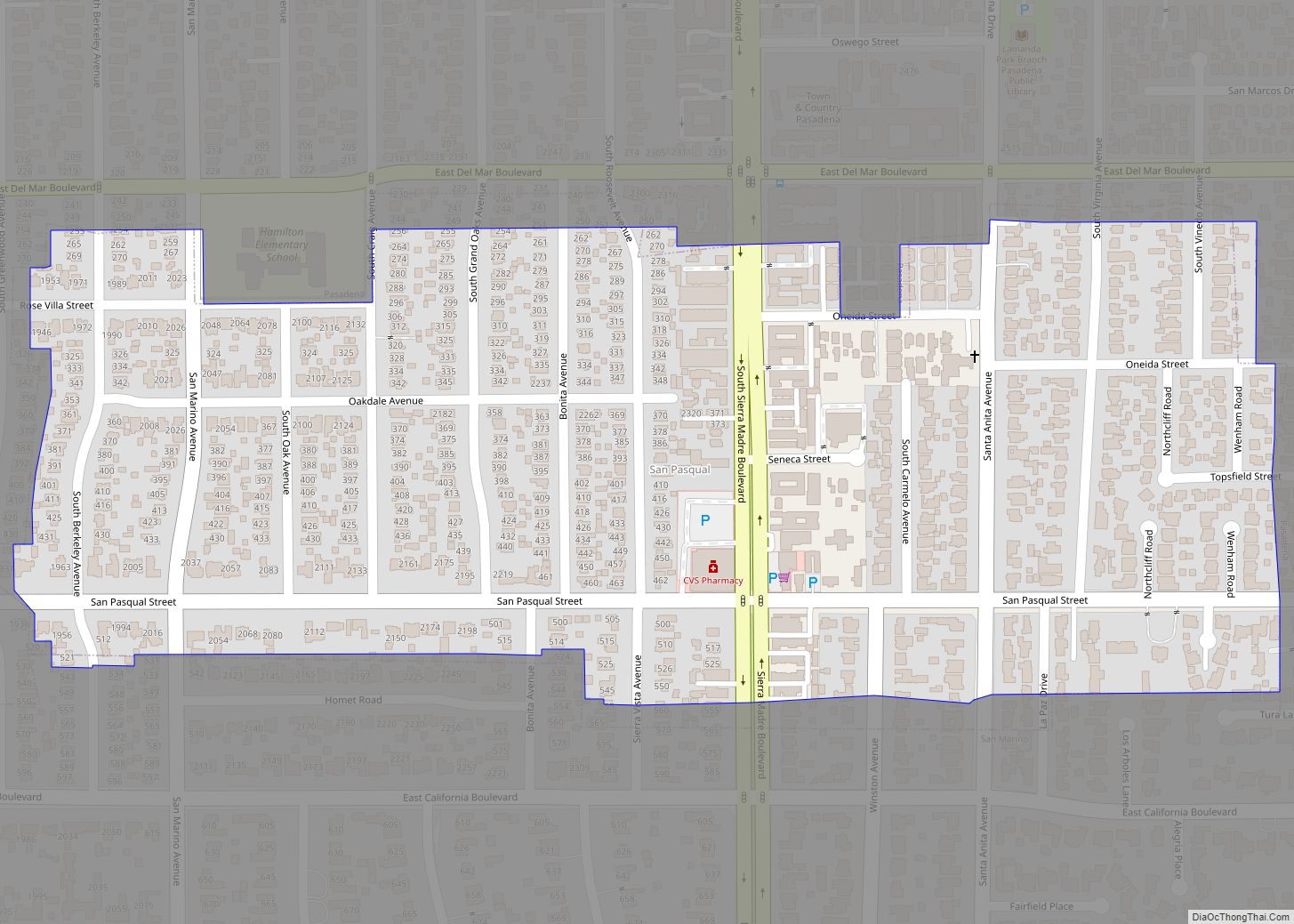
Map of Sanger city

Map of Sanger city, California

Sanger is a city in Fresno County, California, United States. The population was 26,617 at the 2020 census, up from 24,270 at the 2010 census and 18,731 at the 2000 census. Sanger is located 13 miles (21 km) east-southeast of Fresno, at an elevation of 371 feet (113 m). Sanger city overview: Name: Sanger city LSAD … Read more

Map of Sand City city

Map of Sand City

Sand City is a city in Monterey County, California, United States, located on the shores of Monterey Bay, and surrounded on most sides by the larger city of Seaside. Sand City is located 2 miles (3 km) northeast of Monterey, at an elevation of 72 feet (22 m). The population was 325 at the 2020 census. … Read more

Map of San Simeon CDP

Map of San Simeon CDP

San Simeon (Spanish: San Simeón, meaning “St. Simon”) is a village and Census-designated place on the Pacific coast of San Luis Obispo County, California, United States. Its position along State Route 1 is about halfway between Los Angeles and San Francisco, each of those cities being roughly 230 miles (370 km) away. A key feature of … Read more

Map of Santa Margarita CDP

Map of Santa Margarita CDP

Santa Margarita (Spanish for “St. Margaret”) is a town and census-designated place located in San Luis Obispo County, California. It was founded in 1889 near Cuesta Peak and San Luis Obispo along State Route 58. The town’s name comes from the Mexican Alta California land grant of Rancho Santa Margarita. It is home to the … Read more

Map of Santa Fe Springs city

Map of Santa Fe Springs city

Santa Fe Springs (Santa Fe, Spanish for “Holy Faith”) is a city in Los Angeles County, California, United States. It is one of the Gateway Cities of southeast Los Angeles County. The population was 16,223 at the 2010 census, down from 17,438 at the 2000 census. Santa Fe Springs city overview: Name: Santa Fe Springs … Read more

Map of Santa Cruz city, California

Map of Santa Cruz city, California

Santa Cruz (Spanish for “Holy Cross”) is the largest city and the county seat of Santa Cruz County, in Northern California. As of the 2020 census, the city population was 62,956. Situated on the northern edge of Monterey Bay, Santa Cruz is a popular tourist destination, owing to its beaches, surf culture, and historic landmarks. … Read more

Map of Santa Paula city

Map of Santa Paula city

Santa Paula (Spanish for “St. Paula”) is a city in Ventura County, California, United States. Situated amid the orchards of the Santa Clara River Valley, the city advertises itself to tourists as the “Citrus Capital of the World”. Santa Paula was one of the early centers of California’s petroleum industry. The Union Oil Company Building, … Read more

Map of Santa Nella CDP

Map of Santa Nella CDP

Santa Nella is an unincorporated village and census-designated place (CDP) in Merced County, California, United States. It is located 10 miles (16 km) west-northwest of Los Banos at an elevation of 154 feet (47 m). As of the 2020 census, Santa Nella had a population of 2,211, up from 1,380 at the 2010 census. The site’s status … Read more

Map of Santa Monica city

Map of Santa Monica city, California

Santa Monica, from Santa Mónica (Spanish for ‘Saint Monica’), is a city in Los Angeles County, situated along Santa Monica Bay on California‘s South Coast. Santa Monica’s 2020 U.S. Census population was 93,076. Santa Monica is a popular resort town, owing to its climate, beaches, and hospitality industry. It has a diverse economy, hosting headquarters … Read more

Map of Santa Venetia CDP

Map of Santa Venetia CDP

Santa Venetia is a census-designated place (CDP) in Marin County, California, United States. It is located 1.5 miles (2.4 km) north of downtown San Rafael, at an elevation of 56 feet (17 m). The population was 4,289 at the 2020 census. Santa Venetia CDP overview: Name: Santa Venetia CDP LSAD Code: 57 LSAD Description: CDP (suffix) State: … Read more

Map of Santa Susana CDP

Map of Santa Susana CDP

Santa Susana (Spanish for “St. Susan”) is a former railroad town located mostly within the City of Simi Valley. A small portion of the community, outside the Simi Valley city limits to the south of the Ventura County Metrolink rail line, is an unincorporated area and census-designated place (CDP). The community is in the eastern … Read more

Map of Santa Rosa Valley CDP

Map of Santa Rosa Valley CDP

Santa Rosa Valley is a rural unincorporated community, named after the eponymous valley in which it lies, located in Ventura County, California, United States. For statistical purposes, the United States Census Bureau has defined Santa Rosa Valley as a census-designated place (CDP). The census definition of the area may not precisely correspond to local understanding … Read more