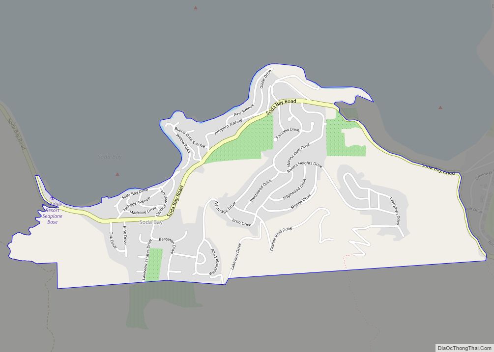
Map of Soledad city

Map of Soledad city

Soledad is a city in Monterey County, California, United States. It is in the Salinas Valley, 21 miles (34 km) southeast of Salinas, the county seat. Soledad’s population was 24,925 at the 2020 census, down from 25,738 in 2010. Soledad’s origins started with Mission Nuestra Señora de la Soledad, founded by the Spanish in 1791, under … Read more

Map of Solana Beach city

Map of Solana Beach city

Solana Beach (Solana, Spanish for “warm wind”) is a coastal city in San Diego County, California. Its population was at 12,941 at the 2020 U.S. Census, up from 12,867 at the 2010 Census. Solana Beach city overview: Name: Solana Beach city LSAD Code: 25 LSAD Description: city (suffix) State: California County: San Diego County Incorporated: … Read more

Map of Soda Springs CDP

Map of Soda Springs CDP, California

Soda Springs (formerly, Summit Valley, Soda Springs Station, Hopkins, Hopkins Springs, and Tinkers Station) is an unincorporated community and census-designated place (CDP) in Nevada County, California, United States. Soda Springs is located 3 miles (4.8 km) west of Donner Pass. The population was 81 at the 2010 census. The Soda Springs Ski Resort is located just … Read more

Map of Sonora city

Map of Sonora city, California

Sonora is the county seat of Tuolumne County, California, United States. Founded during the California Gold Rush by Mexican miners from Sonora (after which the city is named), the city population was 4,994 during the 2020 Census, an increase of 91 from the 4,903 counted during the 2010 Census. Sonora is the only incorporated community … Read more

Map of Sonoma city

Map of Sonoma city

Sonoma is a city in Sonoma County, California, United States, located in the North Bay region of the San Francisco Bay Area. Sonoma is one of the principal cities of California’s Wine Country and the center of the Sonoma Valley AVA. Sonoma’s population was 10,739 as of the 2020 census, while the Sonoma urban area … Read more

Map of Solvang city

Map of Solvang city

Solvang (Danish for ‘sunny field’; /ˈsɒlvæŋ/) is a city in Santa Barbara County, California. It is located in the Santa Ynez Valley. The population was 6,126 at the 2020 census, up from 5,245 at the 2010 census. Solvang was founded in 1911 and incorporated as a city on May 1, 1985. Solvang is often dubbed … Read more

Map of South Dos Palos CDP

Map of South Dos Palos CDP

South Dos Palos (formerly Dos Palos Station) is an unincorporated community and census-designated place (CDP) in Merced County, California, United States. It is located 2 miles (3 km) southwest of Dos Palos at an elevation of 118 feet (36 m). The population was 1,747 at the 2020 census, up from 1,620 at the 2010 census. South Dos … Read more

Map of Soulsbyville CDP

Map of Soulsbyville CDP

Soulsbyville is an unincorporated census-designated place in Tuolumne County, California. The population was 2,215 at the time of the 2010 census, up from 1,729 at the time of the 2000 census. Formerly a California Gold Rush town, Soulsbyville is now registered as a California Historical Landmark. Soulsbyville CDP overview: Name: Soulsbyville CDP LSAD Code: 57 … Read more

Map of Soquel CDP

Map of Soquel CDP

Soquel (/soʊˈkɛl/; Ohlone: Sokel) is an unincorporated town and census-designated place (CDP) in Santa Cruz County, California, located on the northern coast of Monterey Bay. The population was 9,980 at the 2020 census. Soquel CDP overview: Name: Soquel CDP LSAD Code: 57 LSAD Description: CDP (suffix) State: California County: Santa Cruz County Elevation: 33 ft (10 m) … Read more

Map of South Lake Tahoe city

Map of South Lake Tahoe city

South Lake Tahoe is the most populous city in El Dorado County, California, United States, in the Sierra Nevada mountains. The city’s population was 21,330 at the 2020 census, down from 21,403 at the 2010 census. The city, along the southern edge of Lake Tahoe, extends about 5 miles (8 km) west-southwest along U.S. Route 50, … Read more

Map of South Gate city

Map of South Gate city

South Gate is the 19th largest city in Los Angeles County, California, United States, with 7.4 square miles (19 km). South Gate is located 7 miles (11 km) southeast of Downtown Los Angeles. It is part of the Gateway Cities region of southeastern Los Angeles County. The city was incorporated on January 20, 1923, and it became … Read more

Map of South El Monte city

Map of South El Monte city

South El Monte is a city in the San Gabriel Valley, in Los Angeles County, California, United States. At the 2010 census, the city had a population of 20,116, down from 21,144 at the 2000 census. South El Monte city overview: Name: South El Monte city LSAD Code: 25 LSAD Description: city (suffix) State: California … Read more