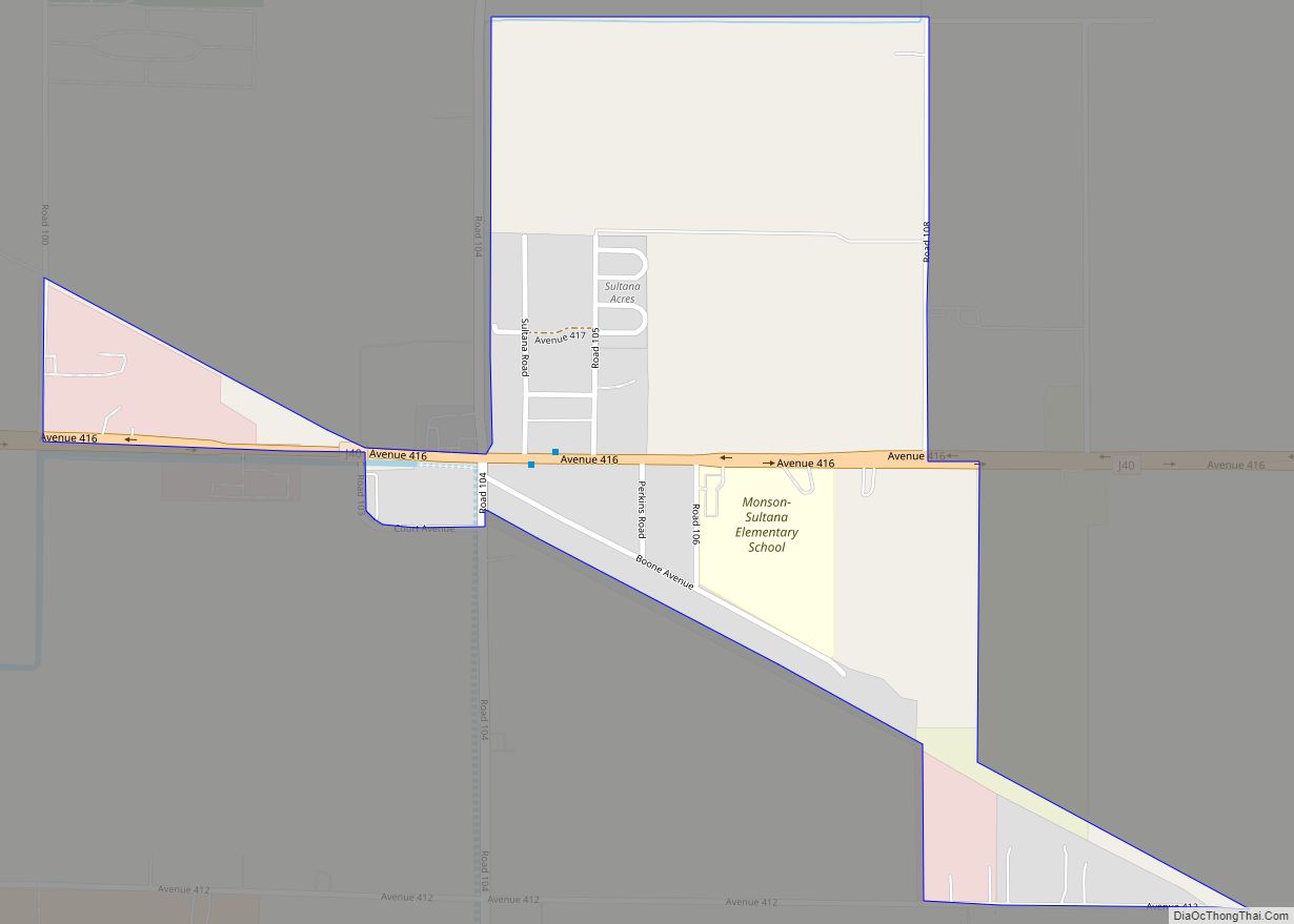
Map of Sunnyside CDP

Map of Sunnyside CDP, California

Sunnyside (formerly, Maltermoro) is a census-designated place in Fresno County, California. It is located on the Southern Pacific Railroad 5 miles (8 km) north-northeast of Malaga, at an elevation of 328 ft (100 m). It is an eastern suburb of Fresno. At the 2010 census, Sunnyside’s population was 4,235. The Maltermoro post office operated from 1894 to 1913. … Read more

Map of Sunnyside-Tahoe City CDP

Map of Sunnyside-Tahoe City CDP

Sunnyside–Tahoe City is a census-designated place (CDP) in Placer County, California, located on the northwest shore of Lake Tahoe. The population was 1,557 at the 2010 census, down from 1,761 at the 2000 census, and a total area of 3.4 sq mi (8.8 km), all of it land. It comprises two communities, Sunnyside, and Tahoe City. Sunnyside-Tahoe City … Read more

Map of Sunny Slopes CDP

Map of Sunny Slopes CDP

Sunny Slopes is an unincorporated community and census-designated place (CDP) in Mono County, California, United States. It sits at an elevation of 7,198 feet (2,194 m). As of the 2020 census, the population was 139, down from 182 in 2010. Sunny Slopes CDP overview: Name: Sunny Slopes CDP LSAD Code: 57 LSAD Description: CDP (suffix) State: … Read more

Map of Sutter Creek city

Map of Sutter Creek city

Sutter Creek (formerly spelled Sutter’s Creek and Suttercreek; formerly named Suttersville) is a city in Amador County, California, United States. The population was 2,501 at the 2010 census, up from 2,303 at the 2000 census. It is accessible via State Route 49. Sutter Creek city overview: Name: Sutter Creek city LSAD Code: 25 LSAD Description: … Read more

Map of Susanville city

Map of Susanville city

Susanville (formerly known as Rooptown) is a town in and the county seat of Lassen County, California, United States. Susanville is located on the Susan River in the southern part of the county, at an elevation of 4,186 feet (1,276 m). Its population is 16,728 as of the 2020 census, down from 17,947 from the 2010 … Read more

Map of Sunol CDP

Map of Sunol CDP, California

Sunol (Spanish: Suñol) is an unincorporated area and census-designated place in Alameda County, California. Located in the Sunol Valley of the East Bay, the population was 913 at the 2010 census. It is best known as the location of the Sunol Water Temple and for its historic tourist railroad system, the Niles Canyon Railway. Sunol … Read more

Map of Taft Heights CDP

Map of Taft Heights CDP

Taft Heights (formerly, Boust City) is a census-designated place (CDP) in Kern County, California, United States. Taft Heights is located 1 mile (1.6 km) west-southwest of Taft, at an elevation of 1,178 feet (359 m). The population was 1,949 at the 2010 census, up from 1,865 at the 2000 census. Taft Heights CDP overview: Name: Taft Heights … Read more

Map of Swall Meadows CDP

Map of Swall Meadows CDP

Swall Meadows CDP overview: Name: Swall Meadows CDP LSAD Code: 57 LSAD Description: CDP (suffix) State: California County: Mono County FIPS code: 0677430 Online Interactive Map Swall Meadows online map. Source: Basemap layers from Google Map, Open Street Map (OSM), Arcgisonline, Wmflabs. Boundary Data from Database of Global Administrative Areas. Swall Meadows location map. Where … Read more

Map of Sutter CDP

Map of Sutter CDP

Sutter, formerly South Butte and Sutter City, is a census-designated place (CDP) in Sutter County, California, United States. It is part of the Yuba City Metropolitan Statistical Area within the Greater Sacramento CSA. The population as of the 2010 census was 2,904, up from 2,885 at the 2000 census. Sutter CDP overview: Name: Sutter CDP … Read more

Map of Tahoe Vista CDP

Map of Tahoe Vista CDP

Tahoe Vista is a census-designated place located on the north shore of Lake Tahoe in Placer County, California. It is part of the Sacramento–Arden-Arcade–Roseville Metropolitan Statistical Area. The population was 1,433 at the 2010 census, down from 1,668 at the 2000 census. Tahoe Vista CDP overview: Name: Tahoe Vista CDP LSAD Code: 57 LSAD Description: … Read more

Map of Taft city

Map of Taft city, California

Taft (formerly Moron, Moro, and Siding Number Two) is a city in the foothills at the extreme southwestern edge of the San Joaquin Valley, in Kern County, California. Taft is located 32 miles (51 km) west-southwest of Bakersfield, at an elevation of 955 feet (291 m). The population was 9,327 at the 2010 census. According to the … Read more

Map of Taft Mosswood CDP

Map of Taft Mosswood CDP

Taft Mosswood is a census-designated place (CDP) in San Joaquin County, California, United States. The population was 1,530 at the 2010 census, up from 1,388 at the 2000 census. It comprises an unincorporated “island” within the City of Stockton. Taft Mosswood CDP overview: Name: Taft Mosswood CDP LSAD Code: 57 LSAD Description: CDP (suffix) State: … Read more