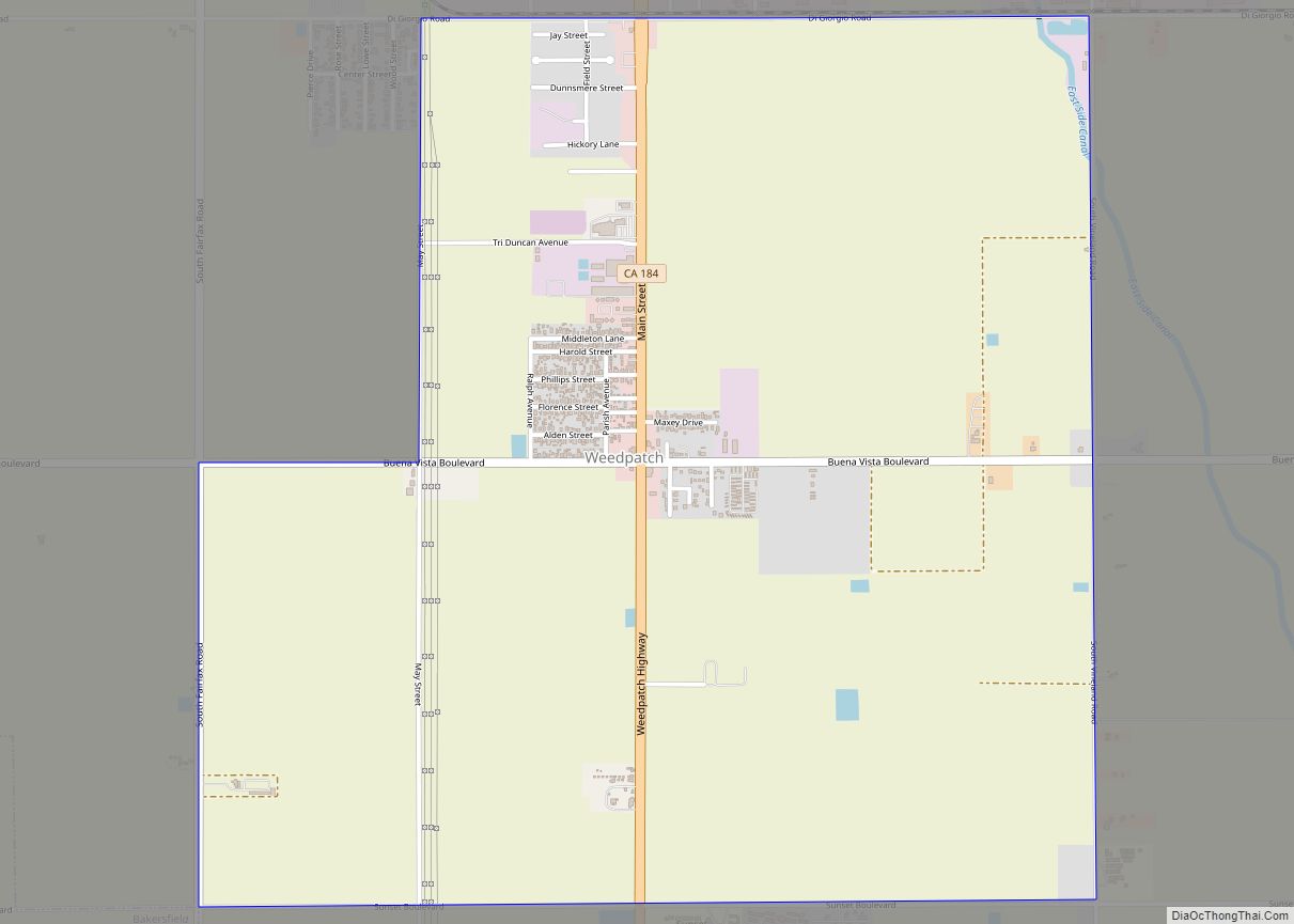
Map of West Carson CDP

Map of West Carson CDP

West Carson is an unincorporated community in Los Angeles County, California. The population was 21,699 at the 2010 census, up from 21,138 at the 2000 census. For statistical purposes, the United States Census Bureau has defined West Carson as a census-designated place (CDP). West Carson CDP overview: Name: West Carson CDP LSAD Code: 57 LSAD … Read more

Map of West Bishop CDP

Map of West Bishop CDP

West Bishop is a census-designated place (CDP) in Inyo County, California, United States. The population was 2,607 at the 2010 census, down from 2,807 at the 2000 census. West Bishop CDP overview: Name: West Bishop CDP LSAD Code: 57 LSAD Description: CDP (suffix) State: California County: Inyo County Elevation: 4,403 ft (1,342 m) Total Area: 8.760 sq mi (22.687 km²) … Read more

Map of West Athens CDP

Map of West Athens CDP

West Athens is a census-designated place (CDP) in Los Angeles County, California. The population was 9,393 at the 2020 census. It is an unincorporated community within the 2nd Supervisorial District of Los Angeles County. West Athens is served by the Los Angeles County Sheriff’s Department, operating out of the South Los Angeles Station. The approximate … Read more

Map of West Hollywood city

Map of West Hollywood city

West Hollywood is a city in Los Angeles County, California, United States. Incorporated in 1984, it is home to the Sunset Strip. As of the 2020 U.S. Census, its population was 35,757. West Hollywood city overview: Name: West Hollywood city LSAD Code: 25 LSAD Description: city (suffix) State: California County: Los Angeles County Incorporated: November 29, 1984 (1984-11-29) … Read more

Map of West Goshen CDP

Map of West Goshen CDP

West Goshen is a census-designated place (CDP) in Tulare County, California. West Goshen sits at an elevation of 272 feet (83 m). The 2010 United States census reported West Goshen’s population was 511. West Goshen CDP overview: Name: West Goshen CDP LSAD Code: 57 LSAD Description: CDP (suffix) State: California County: Tulare County Elevation: 272 ft (83 m) … Read more

Map of West Menlo Park CDP

Map of West Menlo Park CDP

West Menlo Park is a census-designated place and an Unincorporated community in San Mateo County, California, located between the majority of City of Menlo Park, the Town of Atherton, the Sharon Heights neighborhood of Menlo Park and Stanford University (in Santa Clara County). As of the 2020 census, the community had a population of 3,930. … Read more

Map of West Point CDP, California

Map of West Point CDP, California

West Point (formerly, Indian Gulch and Westpoint) is a census-designated place (CDP) in Calaveras County, California, in the United States. As of the 2010 United States Census, West Point’s population was 674, down from 746 as of the 2000 census. The town is registered as California Historical Landmark #268. There is an annual West Point … Read more

Map of West Park CDP

Map of West Park CDP, California

West Park is a census-designated place in Fresno County, California. It is located 5 miles (8 km) southwest of downtown Fresno, at an elevation of 266 ft (81 m). West Park’s population is 1,157. West Park CDP overview: Name: West Park CDP LSAD Code: 57 LSAD Description: CDP (suffix) State: California County: Fresno County Elevation: 266 ft (81 m) Total … Read more

Map of West Modesto CDP

Map of West Modesto CDP

West Modesto is a census-designated place (CDP) in Stanislaus County, California, United States. The population was 5,682 at the 2010 census, down from 6,096 at the 2000 census. It is part of the Modesto Metropolitan Statistical Area. West Modesto CDP overview: Name: West Modesto CDP LSAD Code: 57 LSAD Description: CDP (suffix) State: California County: … Read more

Map of West Sacramento city

Map of West Sacramento city

West Sacramento (also known as West Sac) is a city in Yolo County, California, United States. The city is separated from Sacramento by the Sacramento River, which also separates Sacramento and Yolo counties. It is a fast-growing community; the population was 48,744 at the 2010 census, up from 31,615 at the 2000 census. The traditional … Read more

Map of West Rancho Dominguez CDP

Map of West Rancho Dominguez CDP

West Rancho Dominguez CDP overview: Name: West Rancho Dominguez CDP LSAD Code: 57 LSAD Description: CDP (suffix) State: California County: Los Angeles County FIPS code: 0684780 Online Interactive Map West Rancho Dominguez online map. Source: Basemap layers from Google Map, Open Street Map (OSM), Arcgisonline, Wmflabs. Boundary Data from Database of Global Administrative Areas. West … Read more

Map of West Puente Valley CDP

Map of West Puente Valley CDP

West Puente Valley (pronunciation) is an unincorporated community and census-designated place in Los Angeles County, California, USA, northwest of La Puente. The population was 22,636 at the 2010 census, up from 22,589 at the 2000 census. The community is probably named for its location related to the city of La Puente. West Puente Valley CDP … Read more