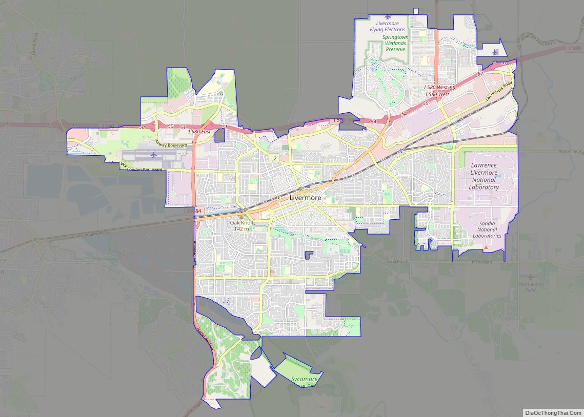
Map of Lodoga CDP

Map of Lodoga CDP

Lodoga (also Ladoga) is a census-designated place in Colusa County, California. It lies at an elevation of 1237 feet (377 m). Lodoga’s population was 184 at the 2020 census. Lodoga CDP overview: Name: Lodoga CDP LSAD Code: 57 LSAD Description: CDP (suffix) State: California County: Colusa County Elevation: 1,237 ft (377 m) Total Area: 3.387 sq mi (8.772 km²) Land … Read more

Map of Lodi city

Map of Lodi city, California

Lodi (/ˈloʊdaɪ/ LOH-dye) is a city located in San Joaquin County, California, in the center portion of California’s Central Valley. The population was 62,134 at the 2010 census. Lodi is best known for wine grape production, although its vintages have historically been less prestigious than those of Sonoma and Napa counties. However, in recent years, … Read more

Map of Lockwood CDP

Map of Lockwood CDP, California

Lockwood is an unincorporated community and census-designated place (CDP) in Monterey County, California, United States. As of the 2020 census it had a population of 368. It is a small community consisting of farms, ranches, and vineyards, in a broad valley encompassed by the coastal mountains. The ZIP Code is 93932, and the community is … Read more

Map of Loma Mar CDP

Map of Loma Mar CDP

Loma Mar (Spanish for “Sea Hill”) is a census-designated place (CDP) in San Mateo County, California. It is near San Mateo County Memorial Park on Pescadero Creek Road and is in area code 650. Loma Mar is between the towns of Pescadero and La Honda, situated in the Santa Cruz Mountains in the western part … Read more

Map of Loma Linda city

Map of Loma Linda city, California

Loma Linda (Spanish for “Beautiful Hill”) is a city in San Bernardino County, California, United States, that was incorporated in 1970. The population was 24,791 at the 2020 census, up from 23,261 at the 2010 census. The central area of the city was originally known as Mound City, while its eastern half was originally the … Read more

Map of Loleta CDP

Map of Loleta CDP

Loleta (Wiyot: Guduwalhat) is a census-designated place in Humboldt County, California. Loleta is located 5.5 miles (9 km) south of Fields Landing, and 15 miles (24 km) south of Eureka at an elevation of 46 feet (14 m). The population was 783 at the 2010 census. Residents live in a central community area and rural outskirts. There are … Read more

Map of Lompico CDP

Map of Lompico CDP

Lompico (from Loma and Pico, Spanish for “Hill” and “Peak”) is a census-designated place (CDP) in Santa Cruz County, California. Lompico sits at an elevation of 968 feet (295 m). Lompico shares the 95018 ZIP code with Felton. Lompico was founded in 1927. It is in area code 831. The 2010 United States census reported Lompico’s … Read more

Map of Lomita city

Map of Lomita city

Lomita (Spanish for “Little hill”) is a city in Los Angeles County, California, United States. The population was 20,921 at the 2020 census, up from 20,256 at the 2010 census. Lomita city overview: Name: Lomita city LSAD Code: 25 LSAD Description: city (suffix) State: California County: Los Angeles County Incorporated: June 30, 1964 Elevation: 95 ft … Read more

Map of Loma Rica CDP

Map of Loma Rica CDP

Loma Rica (Spanish for “Rich Hill”) is a census-designated place (CDP) in Yuba County, California, United States. The population was 2,368 at the 2010 census, up from 2,075 at the 2000 census. Loma Rica is located 15 miles (24 km) northeast of Marysville. Loma Rica CDP overview: Name: Loma Rica CDP LSAD Code: 57 LSAD Description: … Read more

Map of Lone Pine CDP

Map of Lone Pine CDP

Lone Pine is a census-designated place (CDP) in Inyo County, California, United States. Lone Pine is located 16 mi (26 km) south-southeast of Independence, at an elevation of 3,727 ft (1,136 m). The population was 2,035 at the 2010 census, up from 1,655 at the 2000 census. The town is located in the Owens Valley, near the Alabama Hills … Read more

Map of London CDP, California

Map of London CDP, California

London is a census designated place (CDP) in Tulare County, California, United States. The population was 1,869 at the 2010 census, up from 1,848 at the 2000 census (which was up from 1,638 in 1990). London CDP overview: Name: London CDP LSAD Code: 57 LSAD Description: CDP (suffix) State: California County: Tulare County Elevation: 299 ft … Read more

Map of Lompoc city

Map of Lompoc city

Lompoc (/ˈlɒmpoʊk/ LOM-poke; Chumanshan Purisimeño: Lum Poc) is a city in Santa Barbara County, California. Located on the Central Coast, Lompoc has a population of 43,834 as of July 2021. Lompoc has been inhabited for thousands of years by the Chumash people, who called the area Lum Poc, meaning ‘stagnant waters’ or ‘lagoon’ in the … Read more