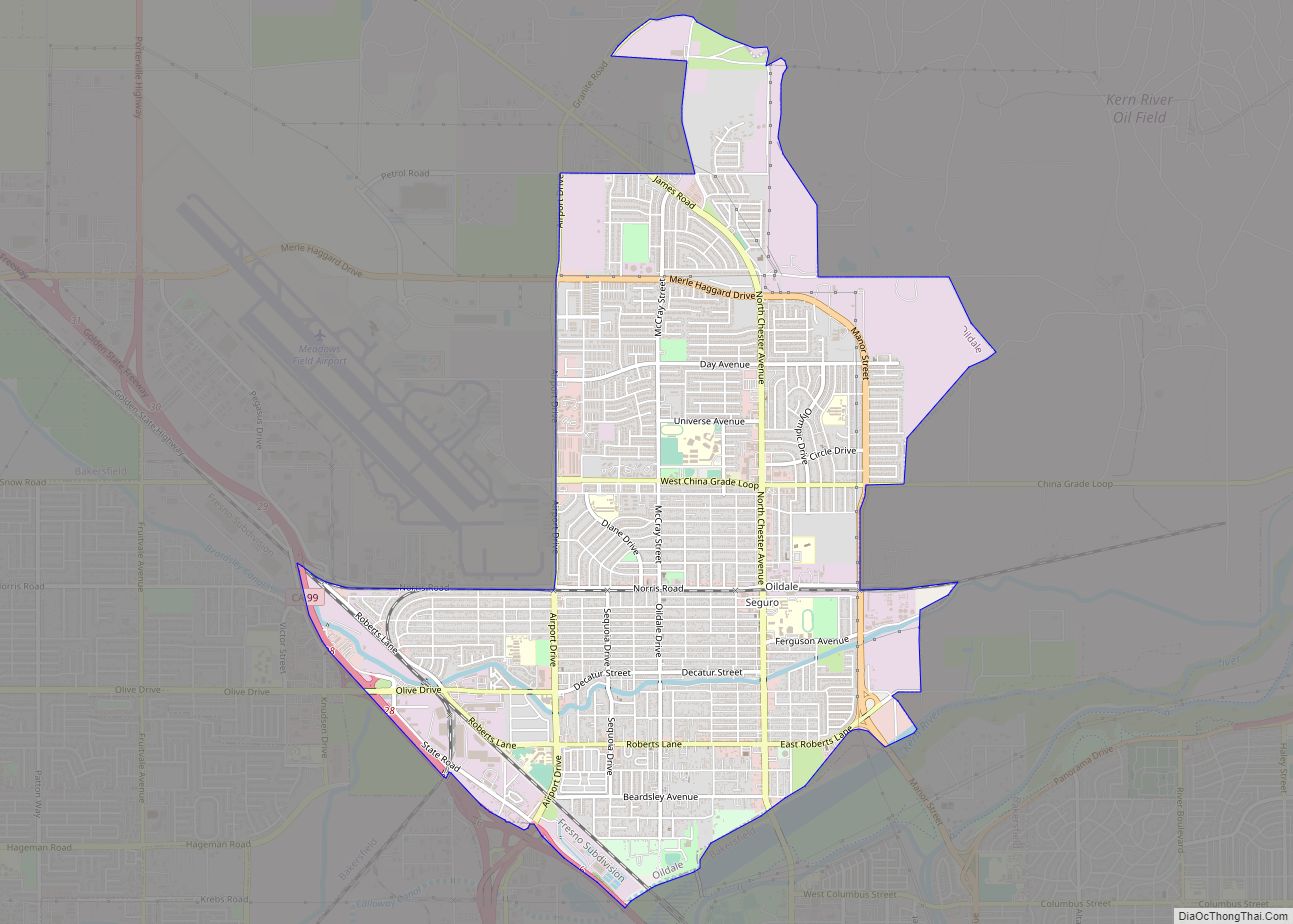
Map of Olivehurst CDP

Map of Olivehurst CDP

Olivehurst (formerly, Denniston) is a census-designated place (CDP) in Yuba County, California, United States. The population was 13,656 at the 2010 census, up from 11,061 at the 2000 census. Olivehurst is located 4 miles (6.4 km) south-southeast of Marysville. Olivehurst CDP overview: Name: Olivehurst CDP LSAD Code: 57 LSAD Description: CDP (suffix) State: California County: Yuba … Read more

Map of Old Station CDP

Map of Old Station CDP

Old Station is a census-designated place (CDP) in Shasta County, California. It is located 13 miles (21 km) north of Lassen Volcanic National Park, directly between Redding and Susanville. The ZIP code in Old Station is 96071 and the area code 530. Old Station sits at an elevation of 4,386 feet (1,337 m). Its population is 64 … Read more

Map of Old Fig Garden CDP

Map of Old Fig Garden CDP

Old Fig Garden (formerly, Fig Garden) is a census-designated place in Fresno County, California. It lies at an elevation of 312 feet (95 m). The city of Fresno, through annexations, has entirely circled Fig Garden. Old Fig Garden’s population was 5,365 at the 2010 census. Old Fig Garden CDP overview: Name: Old Fig Garden CDP … Read more

Map of Orangevale CDP

Map of Orangevale CDP

Orangevale is a census-designated place (CDP) in Sacramento County, California, United States. It is part of the Sacramento–Arden-Arcade–Roseville Metropolitan Statistical Area. The population was 33,960 at the 2010 census, up from 26,705 at the 2000 census. It is located approximately 25 miles (40 km) northeast of Sacramento. The community is known for its rolling hills that … Read more

Map of Orange Cove city

Map of Orange Cove city

Orange Cove is a city in Fresno County, California, United States. The population was 9,078 at the 2010 census, up from 7,722 at the 2000 census. Orange Cove city overview: Name: Orange Cove city LSAD Code: 25 LSAD Description: city (suffix) State: California County: Fresno County Incorporated: January 20, 1948 Elevation: 423 ft (129 m) Total Area: … Read more

Map of Onyx CDP

Map of Onyx CDP

Onyx (formerly, Scodie) is a census-designated place (CDP) in Kern County, California, United States. Onyx is located 3.5 miles (6 km) east-northeast of Weldon in the South Fork Valley at an elevation of 2,795 feet (852 m). The population was 475 at the 2010 census, down from 476 at the 2000 census. Onyx CDP overview: Name: Onyx … Read more

Map of Orinda city

Map of Orinda city

Orinda is a city in Contra Costa County, California, United States. The city’s population as of the 2020 census is estimated at 19,514 residents. Orinda city overview: Name: Orinda city LSAD Code: 25 LSAD Description: city (suffix) State: California County: Contra Costa County Incorporated: July 1, 1985 Elevation: 495 ft (151 m) Total Area: 12.87 sq mi (33.33 km²) Land … Read more

Map of Orick CDP

Map of Orick CDP

Orick (formerly, Arekw, Orekw, and Oreq, Yurok: ‘O’rekw ) is a census-designated place situated on the banks of the Redwood Creek in Humboldt County, California. It is located 43 miles (69 km) north of Eureka, at an elevation of 26 feet (8 m). The population was 357 at the 2010 census. Rare minerals orickite and coyoteite … Read more

Map of Orcutt CDP

Map of Orcutt CDP

Orcutt is an unincorporated town in Santa Barbara County, California, United States. Located in the Santa Maria Valley, Orcutt is named for William Warren Orcutt, the manager of the Geological, Land and Engineering Departments of the Union Oil Company. The population of Orcutt was 28,905 at the 2010 census, up from 28,830 at the 2000 … Read more

Map of Oroville East CDP

Map of Oroville East CDP

Oroville East or Kelly Ridge is a census-designated place (CDP) in Butte County, California, United States. The population was 8,280 at the 2010 census, down from 8,680 at the 2000 census. Most citizens are dependent on the commerce of Oroville, and the vast majority of high school students in Kelly Ridge (Oroville East) attend Las … Read more

Map of Orosi CDP

Map of Orosi CDP

Orosi (from Oro, Spanish for “Gold”) is a census-designated place (CDP) in Tulare County, California, United States. The population was 8,770 at the 2010 census, up from 7,318 at the 2000 census. Orosi CDP overview: Name: Orosi CDP LSAD Code: 57 LSAD Description: CDP (suffix) State: California County: Tulare County Elevation: 374 ft (114 m) Total Area: … Read more

Map of Orland city

Map of Orland city, California

Orland is a city in Glenn County, California. The population was 7,291 at the 2010 census, up from 6,281 at the 2000 census, making Orland the most populous and fastest growing city in Glenn County. Orland is located 16 miles (26 km) north of Willows, at an elevation of 259 feet (79 m). Interstate 5, (north–south) … Read more