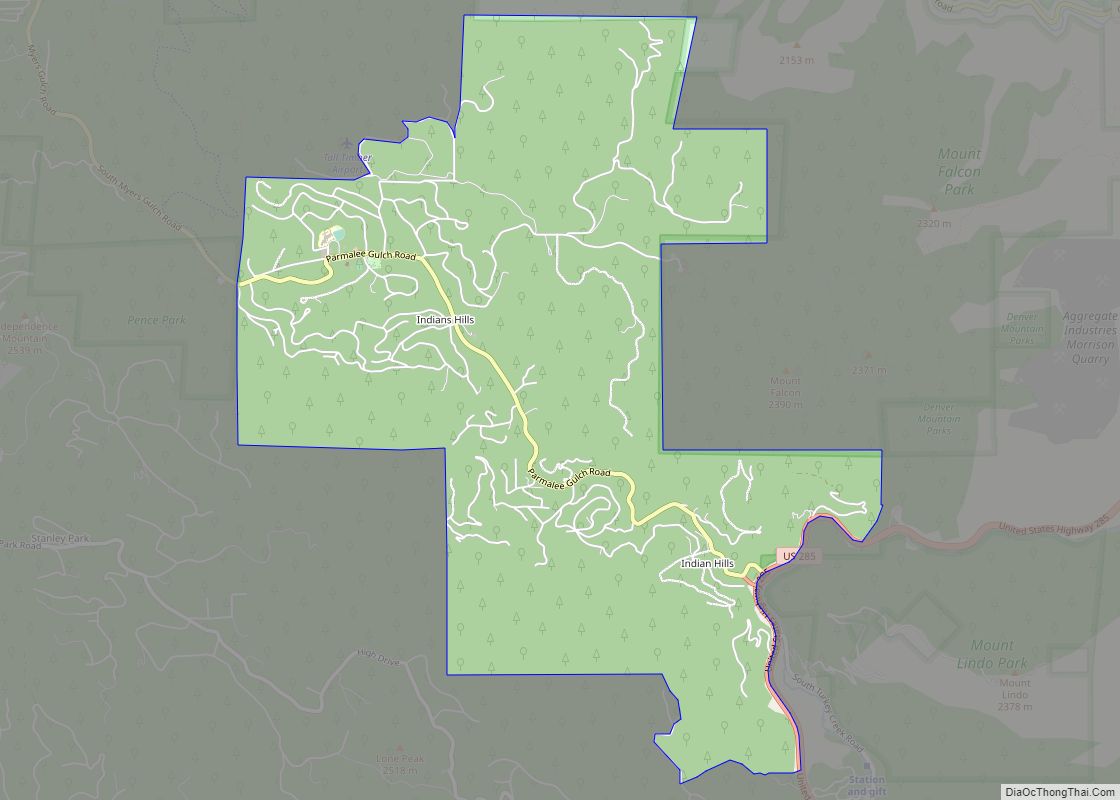
Map of Iliff town

Map of Iliff town

The Town of Iliff is a Statutory Town located in Logan County, Colorado, United States. The population was 246 at the 2020 United States Census. Iliff town overview: Name: Iliff town LSAD Code: 43 LSAD Description: town (suffix) State: Colorado County: Logan County Elevation: 3,835 ft (1,169 m) Total Area: 0.19 sq mi (0.49 km²) Land Area: 0.19 sq mi (0.49 km²) Water … Read more

Map of Ignacio town

Map of Ignacio town

The Town of Ignacio (Ute language: Piinuu) is a Statutory Town in La Plata County, Colorado, United States. The population was 852 at the 2020 United States Census. It is the headquarters of the Southern Ute Indian Reservation. Ignacio town overview: Name: Ignacio town LSAD Code: 43 LSAD Description: town (suffix) State: Colorado County: La … Read more

Map of Jamestown town, Colorado

Map of Jamestown town, Colorado

The historic Town of Jamestown is a Statutory Town in Boulder County, Colorado, United States. The population was 274 at the 2010 United States Census. It was named for James Smith, an early discoverer of gold. Jamestown was hit hard by the September 2013 Colorado floods when the town was isolated due to road damage … Read more

Map of Jackson Lake CDP

Map of Jackson Lake CDP

Jackson Lake is an unincorporated community and a census-designated place (CDP) located in and governed by Morgan County, Colorado, United States. The CDP is a part of the Fort Morgan, CO Micropolitan Statistical Area. The population of the Jackson Lake CDP was 131 at the United States Census 2020. The Weldona post office (Zip Code … Read more

Map of Inverness CDP, Colorado

Map of Inverness CDP, Colorado

Inverness is an unincorporated community and a census-designated place (CDP) located in and governed by Arapahoe County, Colorado, United States. The CDP is a part of the Denver–Aurora–Lakewood, CO Metropolitan Statistical Area. The population of the Inverness CDP was 2,226 at the United States Census 2020. The Inverness Metropolitan Improvement District and the Inverness Water … Read more

Map of Johnson Village CDP

Map of Johnson Village CDP

Johnson Village is an unincorporated community and a census-designated place (CDP) located in and governed by Chaffee County, Colorado, United States. The population of the Johnson Village CDP was 299 at the United States Census 2020. The Buena Vista post office (Zip Code 81211) serves the area. Johnson Village CDP overview: Name: Johnson Village CDP … Read more

Map of Joes CDP

Map of Joes CDP

Joes is a census-designated place (CDP) and post office in and governed by Yuma County, Colorado, United States. The Joes post office has the ZIP Code 80822. At the United States Census 2020, the population of the Joes CDP was 82. Joes CDP overview: Name: Joes CDP LSAD Code: 57 LSAD Description: CDP (suffix) State: … Read more

Map of Jansen CDP

Map of Jansen CDP, Colorado

Jansen is an unincorporated community and a census-designated place (CDP) located in and governed by Las Animas County, Colorado, United States. The population of the Jansen CDP was 101 at the United States Census 2020. The Trinidad post office (Zip Code 81082) serves the Jansen postal addresses. Jansen CDP overview: Name: Jansen CDP LSAD Code: … Read more

Map of Keenesburg town

Map of Keenesburg town

The Town of Keenesburg is a Statutory Town in Weld County, Colorado, United States. The population was 1,250 at the 2020 United States Census. Keenesburg town overview: Name: Keenesburg town LSAD Code: 43 LSAD Description: town (suffix) State: Colorado County: Weld County Elevation: 4,944 ft (1,507 m) Total Area: 3.46 sq mi (8.96 km²) Land Area: 3.43 sq mi (8.89 km²) Water Area: … Read more

Map of Julesburg town

Map of Julesburg town

Julesburg is the statutory town that is the county seat and the most populous municipality of Sedgwick County, Colorado, United States. The population was 1,307 at the 2020 United States Census. Julesburg town overview: Name: Julesburg town LSAD Code: 43 LSAD Description: town (suffix) State: Colorado County: Sedgwick County Incorporated: November 18, 1886 Elevation: 3,478 ft … Read more

Map of Johnstown town

Map of Johnstown town, Colorado

Johnstown is a home rule municipality in Weld and Larimer counties in the U.S. state of Colorado. The population was 17,303 at the 2020 United States Census. Johnstown town overview: Name: Johnstown town LSAD Code: 43 LSAD Description: town (suffix) State: Colorado County: Larimer County, Weld County Elevation: 4,852 ft (1,479 m) Total Area: 13.84 sq mi (35.84 km²) Land … Read more

Map of Keystone CDP

Map of Keystone CDP, Colorado

Keystone is an unincorporated community and a census-designated place (CDP) located in and governed by Summit County, Colorado, United States. The CDP is a part of the Breckenridge, CO Micropolitan Statistical Area. The population of the Keystone CDP was 1,369 at the United States Census 2020. The Dillon post office (Zip Code 80435) serves Keystone … Read more