Map of Kersey town

Map of Kersey town, Colorado

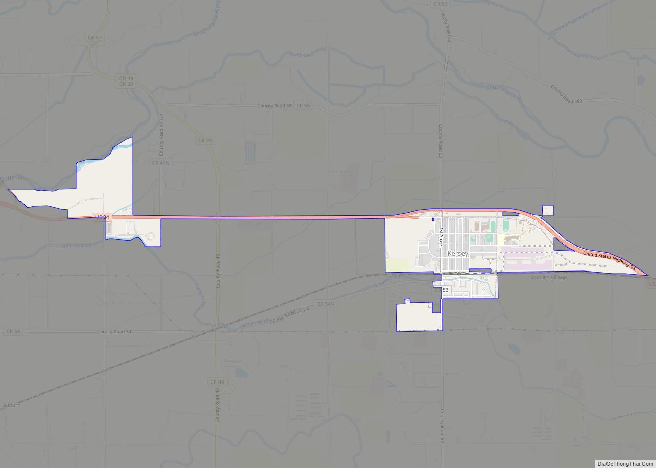
The Town of Kersey is a Statutory Town in Weld County, Colorado, United States. The population was 1,495 at the 2020 United States Census. Kersey town overview: Name: Kersey town LSAD Code: 43 LSAD Description: town (suffix) State: Colorado County: Weld County Elevation: 4,619 ft (1,408 m) Total Area: 2.03 sq mi (5.25 km²) Land Area: 2.02 sq mi (5.24 km²) Water Area: … Read more

Map of Ken Caryl CDP

Map of Ken Caryl CDP

Ken Caryl, commonly known as Ken Caryl Ranch, is an unincorporated community and a census-designated place (CDP) located in and governed by Jefferson County, Colorado, United States. The CDP is a part of the Denver–Aurora–Lakewood, CO Metropolitan Statistical Area. The population of the Ken Caryl CDP was 33,811 at the United States Census 2020. The … Read more

Map of Kirk CDP

Map of Kirk CDP

Kirk is an unincorporated town, a post office, and a census-designated place (CDP) located in and governed by Yuma County, Colorado, United States. The Kirk post office has the ZIP Code 80824. At the United States Census 2020, the population of the Kirk CDP was 61. Kirk CDP overview: Name: Kirk CDP LSAD Code: 57 … Read more

Map of Kiowa town

Map of Kiowa town, Colorado

Kiowa is a home rule municipality town and the county seat of Elbert County, Colorado, United States. The town population was 725 at the 2020 United States Census. Kiowa town overview: Name: Kiowa town LSAD Code: 43 LSAD Description: town (suffix) State: Colorado County: Elbert County Incorporated: December 30, 1912 Elevation: 6,378 ft (1,944 m) Total Area: … Read more

Map of Kim town

Map of Kim town

The Town of Kim is a Statutory Town in Las Animas County, Colorado, United States. The population was 63 at the time of the 2020 United States Census. As of 2014, the town included a complete school system (grades K-12), a post office, and a general store. A post office called Kim has been in … Read more

Map of Kremmling town

Map of Kremmling town

The Town of Kremmling is a Statutory Town in Grand County, Colorado, United States. The town population was 1,509 at the 2020 United States Census. The town sits along the upper Colorado River in the lower arid section of Middle Park between Byers Canyon and Gore Canyon. The town was founded in 1881 during the … Read more

Map of Kittredge CDP

Map of Kittredge CDP

Kittredge is an unincorporated town, a post office, and a census-designated place (CDP) located in and governed by Jefferson County, Colorado, United States. The CDP is a part of the Denver–Aurora–Lakewood, CO Metropolitan Statistical Area. The Kittredge post office has the ZIP code 80457. At the United States Census 2020, the population of the Kittredge … Read more

Map of Kit Carson town

Map of Kit Carson town

Kit Carson is a Statutory Town in Cheyenne County, Colorado, United States. The population was 255 at the 2020 United States Census. Kit Carson town overview: Name: Kit Carson town LSAD Code: 43 LSAD Description: town (suffix) State: Colorado County: Cheyenne County Incorporated: July 13, 1931 Elevation: 4,285 ft (1,306 m) Total Area: 0.58 sq mi (1.51 km²) Land Area: … Read more

Map of La Junta city

Map of La Junta city

La Junta is a home rule municipality in, the county seat of, and the most populous municipality of Otero County, Colorado, United States. The city population was 7,322 at the 2020 United States Census. La Junta is located on the Arkansas River in southeastern Colorado 68 miles (109 km) east of Pueblo. La Junta city overview: … Read more

Map of La Junta Gardens CDP

Map of La Junta Gardens CDP

La Junta Gardens is a Census-designated place (CDP) in and governed by Otero County, Colorado, United States. The population of the La Junta Gardens CDP was 123 at the United States Census 2020. The La Junta post office (Zip Code 81050) serves the area. La Junta Gardens CDP overview: Name: La Junta Gardens CDP LSAD … Read more

Map of La Jara town

Map of La Jara town, Colorado

La Jara is a statutory town in Conejos County, Colorado, United States. The population was 730 at the 2020 United States Census. La Jara town overview: Name: La Jara town LSAD Code: 43 LSAD Description: town (suffix) State: Colorado County: Conejos County Elevation: 7,605 ft (2,318 m) Total Area: 0.41 sq mi (1.06 km²) Land Area: 0.41 sq mi (1.06 km²) Water Area: … Read more

Map of Lafayette city, Colorado

Map of Lafayette city, Colorado

The City of Lafayette (/ˌlɑːfiːˈɛt, ˌlæf-/) is a home rule municipality located in southeastern Boulder County, Colorado, United States. The city population was 30,411 at the 2020 United States Census. Lafayette city overview: Name: Lafayette city LSAD Code: 25 LSAD Description: city (suffix) State: Colorado County: Boulder County Founded: 1888 Incorporated: January 6, 1890 Elevation: … Read more