Map of Terramuggus CDP

Map of Terramuggus CDP

Terramuggus is a census-designated place (CDP) in the town of Marlborough, Hartford County, Connecticut, United States. It contains the town center village and surrounding areas. The population was 1,025 at the 2010 census. Terramuggus CDP overview: Name: Terramuggus CDP LSAD Code: 57 LSAD Description: CDP (suffix) State: Connecticut County: Hartford County Elevation: 463 ft (141 m) Total … Read more

Map of Thomaston CDP, Connecticut

Map of Thomaston CDP, Connecticut

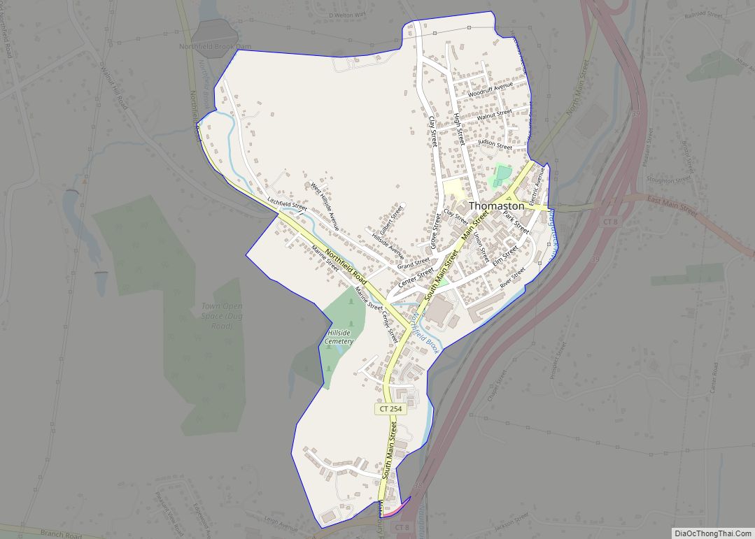
Thomaston is a census-designated place (CDP) in Litchfield County, Connecticut, United States. It comprises the downtown portion of the town of Thomaston. As of the 2010 census, the population of the CDP was 1,910, out of 7,887 in the entire town. Thomaston CDP overview: Name: Thomaston CDP LSAD Code: 57 LSAD Description: CDP (suffix) State: … Read more

Map of Terryville CDP

Map of Terryville CDP, Connecticut

Terryville is a census-designated place (CDP) in Litchfield County, Connecticut, United States, and is the largest village within the town of Plymouth. In the 2010 census, Terryville had a population of 5,387, out of 12,243 in the entire town of Plymouth. The village is named for Eli Terry Jr., the son of the well-known clockmaker … Read more

Map of Trumbull CDP

Map of Trumbull CDP, Connecticut

Trumbull Center is a section or neighborhood of the town of Trumbull in Fairfield County, Connecticut in New England. It is considered the center of the town, and was the seat of town government from 1883 through 1957. The Pequonnock River flows through the center in an easterly direction. The main thoroughfare is Connecticut Route … Read more

Map of Torrington city

Map of Torrington city, Connecticut

Torrington is the most populated municipality and largest city in Litchfield County, Connecticut and the Northwest Hills Planning Region. It is also the core city of Greater Torrington, one of the largest micropolitan areas in the United States. The city population was 35,515 according to the 2020 census. The city is located roughly 23 miles … Read more

Map of Thompsonville CDP

Map of Thompsonville CDP, Connecticut

Thompsonville is a census-designated place (CDP) in the town of Enfield in Hartford County, Connecticut, United States. The population of the CDP was 8,577 at the 2010 census. Thompsonville CDP overview: Name: Thompsonville CDP LSAD Code: 57 LSAD Description: CDP (suffix) State: Connecticut County: Hartford County Elevation: 115 ft (35 m) Total Area: 2.34 sq mi (6.06 km²) Land Area: … Read more

Map of Watertown city

Map of Watertown CDP, Connecticut

Watertown is a census-designated place (CDP) in Litchfield County, Connecticut, United States. It comprises the central village of the town of Watertown. As of the 2010 census, the population of the CDP was 3,574, out of 22,514 in the entire town. Watertown CDP overview: Name: Watertown CDP LSAD Code: 57 LSAD Description: CDP (suffix) State: … Read more

Map of Waterford CDP, Connecticut

Map of Waterford CDP, Connecticut

Waterford is a census-designated place (CDP) comprising the primary village in the town of Waterford, New London County, Connecticut, United States. It is in the southeast part of the town, bordered to the east by the city of New London. U.S. Route 1 (Boston Post Road) passes east–west through the community. As of the 2010 … Read more

Map of Wallingford Center CDP

Map of Wallingford Center CDP

Wallingford Center is a census-designated place (CDP) comprising the primary community in the town of Wallingford, New Haven County, Connecticut, United States. It is in the central and southern parts of the town, bordered to the west by the Wilbur Cross Parkway, to the east by Interstate 91, and to the south by the town … Read more

Map of West Hartford CDP

Map of West Hartford CDP

West Hartford is a town in Hartford County, Connecticut, United States, 5 miles (8.0 km) west of downtown Hartford. The town is part of the Capitol Planning Region. The population was 64,083 at the 2020 census. The town’s popular downtown area is colloquially known as “West Hartford Center,” or simply “The Center,” and is centered on … Read more

Map of Weatogue CDP

Map of Weatogue CDP

Weatogue is a village and census-designated place in Simsbury, Hartford County, Connecticut. The population was 2,776 at the 2010 census. Weatogue CDP overview: Name: Weatogue CDP LSAD Code: 57 LSAD Description: CDP (suffix) State: Connecticut County: Hartford County Elevation: 300 ft (90 m) Total Area: 3.02 sq mi (7.81 km²) Land Area: 3.00 sq mi (7.76 km²) Water Area: 0.02 sq mi (0.05 km²) Total Population: … Read more

Map of Wauregan CDP

Map of Wauregan CDP

Wauregan is a village located in the northwestern corner of the town of Plainfield, Connecticut in the United States. Originally a mill village, Wauregan was established around a cotton mill powered by the Quinebaug River. Wauregan and West Wauregan, across the Quinebaug in the town of Brooklyn, together comprise the Wauregan census-designated place, with a … Read more