Map of Chiefland city

Map of Chiefland city

Chiefland is a city in Levy County, Florida, United States. The population was 2,316 at the 2020 census. Chiefland calls itself the “Gem of the Suwannee Valley” and was incorporated in 1929. Chiefland city overview: Name: Chiefland city LSAD Code: 25 LSAD Description: city (suffix) State: Florida County: Levy County Elevation: 33 ft (10 m) Total Area: … Read more

Map of Cheval CDP

Map of Cheval CDP

Cheval is a census-designated place in Hillsborough County, Florida, United States. The population was 10,702 at the 2010 census, up from 7,602 at the 2000 census. Cheval CDP overview: Name: Cheval CDP LSAD Code: 57 LSAD Description: CDP (suffix) State: Florida County: Hillsborough County Elevation: 59 ft (18 m) Total Area: 6.79 sq mi (17.58 km²) Land Area: 5.95 sq mi (15.41 km²) … Read more

Map of Chipley city

Map of Chipley city

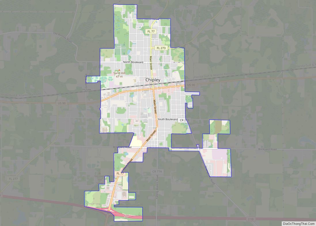
Chipley is a city in and the county seat of Washington County, Florida, United States, located between Tallahassee and Pensacola. Its population was 3,605 in the 2010 U.S. Census. The area is served by Chipley High School. Originally called “Orange”, the city was renamed Chipley in 1882 for William Dudley Chipley, president of the Pensacola … Read more

Map of Chuluota CDP

Map of Chuluota CDP

Chuluota (/tʃuːliˈoʊtə/ choo-lee-OH-tə) is a census-designated place and an unincorporated area in Seminole County, Florida, United States. The population was 2,524 at the 2020 Census. It is part of the Orlando–Kissimmee Metropolitan Statistical Area. Chuluota CDP overview: Name: Chuluota CDP LSAD Code: 57 LSAD Description: CDP (suffix) State: Florida County: Seminole County Elevation: 39 ft (12 m) … Read more

Map of Christmas CDP

Map of Christmas CDP

Christmas is an unincorporated area and census-designated place in Orange County, Florida, United States. It is part of the Orlando–Kissimmee Metropolitan Statistical Area. The population was 1,146 at the 2010 census. Christmas is home to the world’s largest alligator-shaped building, measuring at just over 200 feet (61 m); to Fort Christmas Historical Park, a recreation of … Read more

Map of Chokoloskee CDP

Map of Chokoloskee CDP

Chokoloskee is an unincorporated community and census-designated place (CDP) located at the edge of the Ten Thousand Islands in Collier County, Florida, United States. The population was 359 at the 2010 census. It is part of the Naples–Marco Island Metropolitan Statistical Area. Chokoloskee was inhabited by Native Americans for at least 1500 years before European … Read more

Map of Citrus Hills CDP

Map of Citrus Hills CDP

Citrus Hills is a census-designated place (CDP) in Citrus County, Florida, United States. The population was 7,470 at the 2010 census, up from 4,029 in 2000. The CDP takes its name from The Villages of Citrus Hills, a master-planned community first developed by Gerald Nash and Sam Tamposi in the 1970s. (Although sharing a similar … Read more

Map of Cinco Bayou town

Map of Cinco Bayou town

Cinco Bayou is a town in Okaloosa County, Florida, United States. The population was 383 at the 2010 census. It is part of the Fort Walton Beach–Crestview–Destin Metropolitan Statistical Area. Cinco Bayou town overview: Name: Cinco Bayou town LSAD Code: 43 LSAD Description: town (suffix) State: Florida County: Okaloosa County Elevation: 13 ft (4 m) Total Area: … Read more

Map of Chumuckla CDP

Map of Chumuckla CDP

Chumuckla is a census-designated place in Santa Rosa County, Florida, United States. The population of Chumuckla was 850 in the 2010 census. The population was estimated to be 863 in 2017. Chumuckla CDP overview: Name: Chumuckla CDP LSAD Code: 57 LSAD Description: CDP (suffix) State: Florida County: Santa Rosa County FIPS code: 1212300 Online Interactive … Read more

Map of Clarcona CDP

Map of Clarcona CDP

Clarcona is a census-designated place and unincorporated area in Orange County, Florida, United States. The population was 2,990 at the 2010 census. It is part of the Orlando–Kissimmee Metropolitan Statistical Area. Clarcona CDP overview: Name: Clarcona CDP LSAD Code: 57 LSAD Description: CDP (suffix) State: Florida County: Orange County Elevation: 100 ft (30 m) Total Area: 4.37 sq mi … Read more

Map of Citrus Springs CDP

Map of Citrus Springs CDP

Citrus Springs is a census-designated place (CDP) in Citrus County, Florida, United States. The population was 8,622 as of the 2010 census, up from 4,157 in 2000. Citrus Springs CDP overview: Name: Citrus Springs CDP LSAD Code: 57 LSAD Description: CDP (suffix) State: Florida County: Citrus County Elevation: 95 ft (29 m) Total Area: 21.15 sq mi (54.77 km²) Land … Read more

Map of Citrus Park CDP, Florida

Map of Citrus Park CDP, Florida

Citrus Park is an unincorporated census-designated place in Hillsborough County, Florida, United States. The population was 28,178 at the 2020 census, up from 24,252 at the 2010 census. Citrus Park CDP overview: Name: Citrus Park CDP LSAD Code: 57 LSAD Description: CDP (suffix) State: Florida County: Hillsborough County Elevation: 43 ft (13 m) Total Area: 10.82 sq mi (28.02 km²) … Read more