Map of El Portal village, Florida

Map of El Portal village, Florida

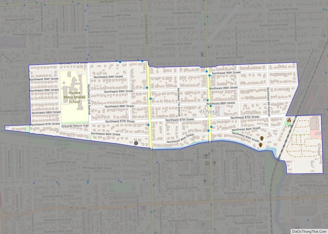
El Portal is a village in Miami-Dade County, Florida, United States. The name is derived from the Spanish term for “the gate”, after two wooden gates that once stood as a gateway to the village. El Portal was originally annexed into the city of Miami in 1925. With the arrival of the Great Depression, Miami … Read more

Map of Egypt Lake-Leto CDP

Map of Egypt Lake-Leto CDP

Egypt Lake-Leto is a census-designated place in an unincorporated part of Hillsborough County, Florida, United States. The population was 35,282 at the 2010 census. The area is located just north of Tampa International Airport. The ZIP code for Egypt Lake-Leto is 33614. Egypt Lake-Leto CDP overview: Name: Egypt Lake-Leto CDP LSAD Code: 57 LSAD Description: … Read more

Map of Eglin AFB CDP

Map of Eglin AFB CDP

Eglin Air Force Base (IATA: VPS, ICAO: KVPS, FAA LID: VPS) is a United States Air Force (USAF) base in the western Florida Panhandle, located about three miles (5 km) southwest of Valparaiso in Okaloosa County. The host unit at Eglin is the 96th Test Wing (formerly the 96th Air Base Wing). The 96 TW is … Read more

Map of Englewood CDP, Florida

Map of Englewood CDP, Florida

Englewood is a census-designated place (CDP) in Charlotte and Sarasota counties in the U.S. state of Florida. As of the 2020 census, it had a population of 20,800. It is part of the Sarasota-Bradenton-Punta Gorda Combined Statistical Area. Englewood CDP overview: Name: Englewood CDP LSAD Code: 57 LSAD Description: CDP (suffix) State: Florida County: Charlotte … Read more

Map of Ellenton CDP

Map of Ellenton CDP, Florida

Ellenton is an unincorporated community and census-designated place (CDP) in Manatee County, Florida, United States. The population was 4,129 at the 2020 census. It is part of the Bradenton-Sarasota-Venice, Florida Metropolitan Statistical Area. Ellenton CDP overview: Name: Ellenton CDP LSAD Code: 57 LSAD Description: CDP (suffix) State: Florida County: Manatee County Elevation: 10 ft (3 m) Total … Read more

Map of Elfers CDP

Map of Elfers CDP

Elfers is a census-designated place (CDP) in Pasco County, Florida, United States. The population was 13,161 at the 2000 census. Elfers CDP overview: Name: Elfers CDP LSAD Code: 57 LSAD Description: CDP (suffix) State: Florida County: Pasco County Elevation: 39 ft (12 m) Total Area: 3.75 sq mi (9.72 km²) Land Area: 3.73 sq mi (9.65 km²) Water Area: 0.03 sq mi (0.06 km²) Total Population: … Read more

Map of Esto town

Map of Esto town

Esto is a town in Holmes County, Florida, United States. The population was 364 at the 2010 census. Esto town overview: Name: Esto town LSAD Code: 43 LSAD Description: town (suffix) State: Florida County: Holmes County Elevation: 233 ft (71 m) Total Area: 2.36 sq mi (6.13 km²) Land Area: 2.18 sq mi (5.64 km²) Water Area: 0.19 sq mi (0.48 km²) Total Population: 341 Population … Read more

Map of Estero village

Map of Estero village

Estero is a village in Lee County, Florida, United States. As of the 2020 census, the population was 36,939. During the 2010 census, Estero was an unincorporated community, or census-designated place, the population at that time was 22,612. Estero incorporated as a village in 2014. In 2019, the village’s estimated population was 33,871. Estero is … Read more

Map of Ensley CDP

Map of Ensley CDP

Ensley is a census-designated place (CDP) in Escambia County, Florida. It is a community in Pensacola, and is located northwest of Pensacola City Limits. As of the 2010 United States Census, the population was 20,602. It is part of the Pensacola–Ferry Pass–Brent Metropolitan Statistical Area. Ensley is a transportation corridor for the Pensacola Area, with … Read more

Map of Fairview Shores CDP

Map of Fairview Shores CDP

Fairview Shores is a census-designated place and an unincorporated area in Orange County, Florida, United States. The population was 10,239 at the 2010 census. It is part of the Orlando–Kissimmee–Sanford, Florida Metropolitan Statistical Area. Fairview Shores CDP overview: Name: Fairview Shores CDP LSAD Code: 57 LSAD Description: CDP (suffix) State: Florida County: Orange County Elevation: … Read more

Map of Everglades city

Map of Everglades city

Everglades city overview: Name: Everglades city LSAD Code: 25 LSAD Description: city (suffix) State: Florida County: Collier County FIPS code: 1221425 Online Interactive Map Everglades online map. Source: Basemap layers from Google Map, Open Street Map (OSM), Arcgisonline, Wmflabs. Boundary Data from Database of Global Administrative Areas. Everglades location map. Where is Everglades city? Everglades … Read more

Map of Eustis city

Map of Eustis city, Florida

Eustis is a city in Lake County, Florida, United States. The population was 23,189 at the 2020 census. It is part of the Orlando–Kissimmee–Sanford Metropolitan Statistical Area. Eustis High School is the town’s local public high school. The City of Eustis holds a festival every year which begins on the last Friday of February and … Read more