Map of Fruitland Park city

Map of Fruitland Park city

Fruitland Park is a city in Lake County, Florida, United States. The population was 4,078 at the 2010 census. The Census Bureau estimated the population in 2018 to be 10,122. It is part of the Orlando–Kissimmee–Sanford Metropolitan Statistical Area. Fruitland Park city overview: Name: Fruitland Park city LSAD Code: 25 LSAD Description: city (suffix) State: … Read more

Map of Fruit Cove CDP

Map of Fruit Cove CDP

Fruit Cove is a census-designated place (CDP) in St. Johns County, Florida, United States. The population was 16,077 at the 2000 census. It is located in the community of St. Johns. Fruit Cove CDP overview: Name: Fruit Cove CDP LSAD Code: 57 LSAD Description: CDP (suffix) State: Florida County: St. Johns County Elevation: 10 ft (3 m) … Read more

Map of Fruitville CDP

Map of Fruitville CDP

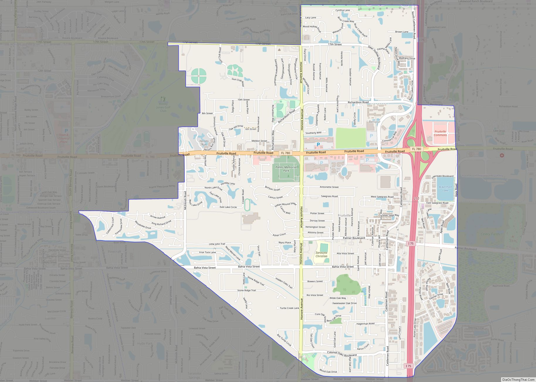
Fruitville is a census-designated place (CDP) in Sarasota County, Florida, United States. The population was 15,484 at the 2020 census. It is part of the North Port–Sarasota–Bradenton Metropolitan Statistical Area. Fruitville CDP overview: Name: Fruitville CDP LSAD Code: 57 LSAD Description: CDP (suffix) State: Florida County: Sarasota County Elevation: 30 ft (9 m) Total Area: 7.13 sq mi (18.46 km²) … Read more

Map of Garcon Point CDP

Map of Garcon Point CDP

Garcon Point is an unincorporated community and census-designated place in Santa Rosa County, Florida, United States. Its population was 457 as of the 2020 census. The community is located on the peninsula of the same name. Garcon Point CDP overview: Name: Garcon Point CDP LSAD Code: 57 LSAD Description: CDP (suffix) State: Florida County: Santa … Read more

Map of Fussels Corner CDP

Map of Fussels Corner CDP

Fussels Corner is a census-designated place (CDP) in Polk County, Florida, United States. The population was 5,313 at time of the 2000 census. It is part of the Lakeland–Winter Haven Metropolitan Statistical Area. Fussels Corner CDP overview: Name: Fussels Corner CDP LSAD Code: 57 LSAD Description: CDP (suffix) State: Florida County: Polk County Elevation: 112 ft … Read more

Map of Fuller Heights CDP

Map of Fuller Heights CDP

Fuller Heights is an unincorporated community and census-designated place in Polk County, Florida, United States. Its population was 10,467 as of the 2020 census. Fuller Heights CDP overview: Name: Fuller Heights CDP LSAD Code: 57 LSAD Description: CDP (suffix) State: Florida County: Polk County Elevation: 112 ft (34 m) Total Area: 4.64 sq mi (12.01 km²) Land Area: 4.32 sq mi (11.19 km²) … Read more

Map of Gateway CDP, Florida

Map of Gateway CDP, Florida

Gateway is a census-designated place (CDP) in Lee County, Florida, United States. The population was 8,401 at the 2010 United States Census. It is part of the Cape Coral-Fort Myers, Florida Metropolitan Statistical Area. The community is located north of Southwest Florida International Airport. Gateway CDP overview: Name: Gateway CDP LSAD Code: 57 LSAD Description: … Read more

Map of Gardner CDP

Map of Gardner CDP, Florida

Gardner is an unincorporated community and census-designated place in Hardee County, Florida, United States. Its population was 364 as of the 2020 census. It is located on U.S. Route 17 about 11 miles (18 km) north of Arcadia. Gardner CDP overview: Name: Gardner CDP LSAD Code: 57 LSAD Description: CDP (suffix) State: Florida County: Hardee County … Read more

Map of Garden Grove CDP, Florida

Map of Garden Grove CDP, Florida

Garden Grove (also known as Garden Grove Estates) is an unincorporated community and census-designated place (CDP) in the U.S. state of Florida, in central Hernando County. The ZIP Code for this community is 34604. As of the 2010 census, Garden Grove had a population of 674. Garden Grove CDP overview: Name: Garden Grove CDP LSAD … Read more

Map of Gifford CDP

Map of Gifford CDP, Florida

Gifford (/ˈɡɪfərd/) is an unincorporated community and census-designated place (CDP) in Indian River County, Florida, United States. It is part of the Sebastian–Vero Beach Metropolitan Statistical Area. The population was 5,511 at the 2020 census. Gifford has a rich African American history. Gifford is one of the poorest communities in Florida. Gifford CDP overview: Name: … Read more

Map of Gibsonton CDP

Map of Gibsonton CDP

Gibsonton, sometimes nicknamed Gibtown, is an unincorporated community and census-designated place in Hillsborough County, Florida, United States. U.S. Route 41 runs through the center of the community. The population was 14,234 at the 2010 census, up from 8,752 at the 2000 census. Gibsonton was famous as a sideshow wintering town, where various people in the … Read more

Map of Geneva CDP, Florida

Map of Geneva CDP, Florida

Geneva is a community, census-designated place and unincorporated area in Seminole County, Florida, United States, with zip code 32732. The population was 2,913 at the 2020 Census. It is part of the Orlando–Kissimmee–Sanford Metropolitan Statistical Area. Geneva is the home of the Little-Big Econ State Forest, home of the big and little Econlockhatchee Rivers. Geneva … Read more