Map of Ives Estates CDP

Map of Ives Estates CDP

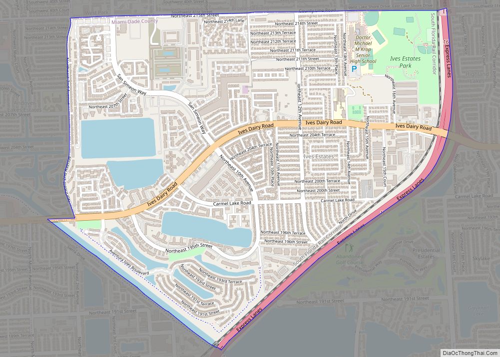
Ives Estates is a census-designated place (CDP) in Miami-Dade County, Florida. The population was 25,005 at the 2020 census, up from 19,525 in 2010. Ives Estates CDP overview: Name: Ives Estates CDP LSAD Code: 57 LSAD Description: CDP (suffix) State: Florida County: Miami-Dade County Elevation: 10 ft (3 m) Total Area: 2.76 sq mi (7.15 km²) Land Area: 2.55 sq mi (6.60 km²) … Read more

Map of Istachatta CDP

Map of Istachatta CDP

Istachatta is an unincorporated community and census-designated place (CDP) in Hernando County, Florida, United States. The population was 116 at the 2010 census, up from 65 at the 2000 census. The name “Istachatta” is derived from a Seminole word meaning “man snake”. Istachatta CDP overview: Name: Istachatta CDP LSAD Code: 57 LSAD Description: CDP (suffix) … Read more

Map of Island Walk CDP

Map of Island Walk CDP

Island Walk is an unincorporated area and a census-designated place (CDP) in Collier County, Florida, United States. As of the 2020 United States census, there were 2,812 people, 1,511 households and 1,085 families residing in the CDP. The population was 3,035 at the 2010 census. It is part of the Naples–Marco Island Metropolitan Statistical Area. … Read more

Map of Jan Phyl Village CDP

Map of Jan Phyl Village CDP

Jan Phyl Village is a census-designated place (CDP) in Polk County, Florida, United States. The population was 5,633 at the 2000 census. It is part of the Lakeland–Winter Haven Metropolitan Statistical Area. Jan Phyl Village CDP overview: Name: Jan Phyl Village CDP LSAD Code: 57 LSAD Description: CDP (suffix) State: Florida County: Polk County Elevation: … Read more

Map of Jacob City city

Map of Jacob City

Jacob City is a city in Jackson County, Florida, United States. The population was 243 at the 2020 census. Jacob City overview: Name: Jacob City LSAD Code: 25 LSAD Description: city (suffix) State: Florida County: Jackson County Elevation: 135 ft (41 m) Total Area: 3.22 sq mi (8.35 km²) Land Area: 3.05 sq mi (7.89 km²) Water Area: 0.18 sq mi (0.46 km²) Total Population: 243 … Read more

Map of Jacksonville Beach city

Map of Jacksonville Beach city

Jacksonville Beach is a coastal resort city in Duval County, Florida, United States. It was incorporated on May 22, 1907, as Pablo Beach, and would later change its name to Jacksonville Beach in 1925. The city is part of group of communities collectively referred to as the Jacksonville Beaches. These communities include Mayport, Atlantic Beach, … Read more

Map of Jay town

Map of Jay town, Florida

Jay is a town in Santa Rosa County, Florida, United States. The population was 533 at the 2010 census. As of 2018, the population estimated by the U.S. Census Bureau was 620. It is part of the Pensacola–Ferry Pass–Brent Metropolitan Statistical Area. Jay town overview: Name: Jay town LSAD Code: 43 LSAD Description: town (suffix) … Read more

Map of Jasper city, Florida

Map of Jasper city, Florida

Jasper is a city and the county seat of Hamilton County, Florida, United States. The population was 4,546 at the 2010 census, up from 1,780 at the 2000 census. The Old Hamilton County Jail and the United Methodist Church in Jasper are on the National Register of Historic Places. One of the largest industries is … Read more

Map of Jasmine Estates CDP

Map of Jasmine Estates CDP

Jasmine Estates is a census-designated place (CDP) in Pasco County, Florida, United States. The population was 18,989 according to the 2010 census. Jasmine Estates CDP overview: Name: Jasmine Estates CDP LSAD Code: 57 LSAD Description: CDP (suffix) State: Florida County: Pasco County Elevation: 3 ft (1 m) Total Area: 3.68 sq mi (9.54 km²) Land Area: 3.63 sq mi (9.40 km²) Water Area: … Read more

Map of June Park CDP

Map of June Park CDP

June Park is a census-designated place (CDP) in Brevard County, Florida. The population was 4,094 at the 2010 United States Census. It is part of the Palm Bay–Melbourne–Titusville Metropolitan Statistical Area. June Park CDP overview: Name: June Park CDP LSAD Code: 57 LSAD Description: CDP (suffix) State: Florida County: Brevard County Elevation: 26 ft (8 m) Total … Read more

Map of Jensen Beach CDP

Map of Jensen Beach CDP

Jensen Beach is an unincorporated community and census-designated place (CDP) in Martin County, Florida, United States. The population was 12,652 at the 2020 census. It is part of the Port St. Lucie, Florida Metropolitan Statistical Area. Jensen Beach CDP overview: Name: Jensen Beach CDP LSAD Code: 57 LSAD Description: CDP (suffix) State: Florida County: Martin … Read more

Map of Jennings town

Map of Jennings town, Florida

Jennings is a town in Hamilton County, Florida, United States. The population was 878 at the 2010 census, up from 833 at the 2000 census. Actor Andrew Prine was born here. Jennings town overview: Name: Jennings town LSAD Code: 43 LSAD Description: town (suffix) State: Florida County: Hamilton County Elevation: 141 ft (43 m) Total Area: 2.91 sq mi … Read more