Map of Pembroke Park town

Map of Pembroke Park town

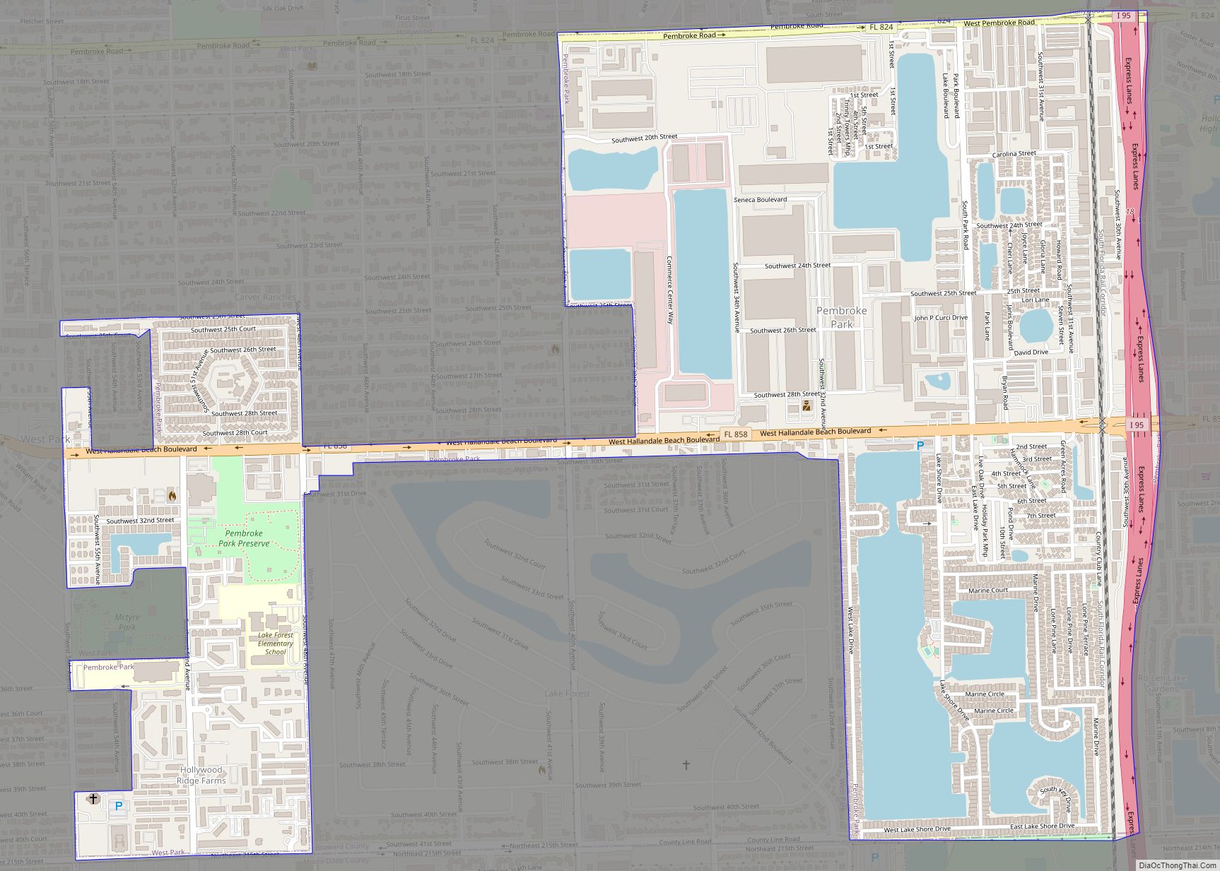
Pembroke Park is a town in Broward County, Florida, United States. The town took its name from its location along Pembroke Road. As of the 2020 census, the population was 6,260. It is part of the South Florida metropolitan area, which was home to 5,564,635 people at the 2010 census. Almost one-half of its residents … Read more

Map of Pelican Bay CDP

Map of Pelican Bay CDP, Florida

Pelican Bay is a census-designated place (CDP) in Collier County, Florida, United States. The population was 6,346 at the 2010 census. It is part of the Naples–Marco Island Metropolitan Statistical Area. Pelican Bay CDP overview: Name: Pelican Bay CDP LSAD Code: 57 LSAD Description: CDP (suffix) State: Florida County: Collier County Elevation: 13 ft (4 m) Total … Read more

Map of Pebble Creek CDP

Map of Pebble Creek CDP

Pebble Creek is a census-designated place (CDP) in Hillsborough County, Florida, United States. The population was 9,624 at the 2020 census, up from 7,622 at the 2010 census. Pebble Creek is located in the unincorporated portion of New Tampa, and is primarily a residential zone. Pebble Creek CDP overview: Name: Pebble Creek CDP LSAD Code: … Read more

Map of Pierson town

Map of Pierson town, Florida

Pierson is a town in Volusia County, Florida, United States. The population was 1,542 as of the 2020 census. Pierson bills itself as the “Fern Capital of the World”. The town is heavily reliant on agriculture which mainly consists of fern growing. Its ferns are exported worldwide for use in floral arrangements and other decorations. … Read more

Map of Perry city, Florida

Map of Perry city, Florida

Perry is a city and the county seat of Taylor County, Florida, United States. As of 2010, the population recorded by the U.S. Census Bureau is 7,017. The city was named for Madison Perry, fourth Governor of the State of Florida and a Confederate colonel during the American Civil War. Perry city overview: Name: Perry … Read more

Map of Penney Farms town

Map of Penney Farms town

Penney Farms is a town in Clay County, Florida, United States. The population was 749 at the 2010 census. Penney Farms town overview: Name: Penney Farms town LSAD Code: 43 LSAD Description: town (suffix) State: Florida County: Clay County Elevation: 95 ft (29 m) Total Area: 1.46 sq mi (3.78 km²) Land Area: 1.46 sq mi (3.78 km²) Water Area: 0.00 sq mi (0.00 km²) Total … Read more

Map of Pine Hills CDP, Florida

Map of Pine Hills CDP, Florida

Pine Hills is a census-designated place (CDP) and unincorporated subdivision in Orange County, Florida, United States, west of Orlando. Per the 2020 U.S. Census, the population was 66,111. It is a part of the Orlando–Kissimmee–Sanford, Florida Metropolitan Statistical Area (home to 2,134,311 people in 2010). Pine Hills is home to several parks, five elementary schools, … Read more

Map of Pine Castle CDP

Map of Pine Castle CDP

Pine Castle is a census-designated place and unincorporated area in Orange County, Florida, United States. It is part of the Orlando–Kissimmee–Sanford, Florida Metropolitan Statistical Area. Pine Castle CDP overview: Name: Pine Castle CDP LSAD Code: 57 LSAD Description: CDP (suffix) State: Florida County: Orange County Elevation: 98 ft (30 m) Total Area: 2.69 sq mi (6.98 km²) Land Area: 2.42 sq mi … Read more

Map of Pine Air CDP

Map of Pine Air CDP

Pine Air is a census-designated place in Palm Beach County, Florida, United States. Its population was 2,190 as of the 2020 census. Pine Air is bordered by State Road 809 to the west and the village of Palm Springs to the south. Pine Air CDP overview: Name: Pine Air CDP LSAD Code: 57 LSAD Description: … Read more

Map of Pine Lakes CDP

Map of Pine Lakes CDP

Pine Lakes is an unincorporated community and census-designated place (CDP) in Lake County, Florida, United States. The population was 862 at the 2010 census, up from 755 at the 2000 census. It is part of the Orlando–Kissimmee Metropolitan Statistical Area. Pine Lakes CDP overview: Name: Pine Lakes CDP LSAD Code: 57 LSAD Description: CDP (suffix) … Read more

Map of Pine Island CDP

Map of Pine Island CDP, Florida

Pine Island is an unincorporated community and census-designated place (CDP) in Hernando County, Florida, United States. The population was 64 at the 2010 census, unchanged from the 2000 census. Pine Island CDP overview: Name: Pine Island CDP LSAD Code: 57 LSAD Description: CDP (suffix) State: Florida County: Hernando County Elevation: 3 ft (1 m) Total Area: 0.08 sq mi … Read more

Map of Pine Island Center CDP

Map of Pine Island Center CDP

Pine Island Center is an unincorporated community and census-designated place (CDP) located on Pine Island in Lee County, Florida, United States. The population was 1,942 at the 2020 census. It is part of the Cape Coral-Fort Myers, Florida Metropolitan Statistical Area. Pine Island Center CDP overview: Name: Pine Island Center CDP LSAD Code: 57 LSAD … Read more