Map of Pine Ridge CDP, Florida

Map of Pine Ridge CDP, Florida

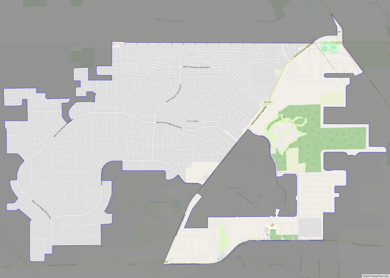
Pine Ridge is an unincorporated community and census-designated place (CDP) in Citrus County, Florida, United States. The population was 9,598 at the 2010 census, up from 5,490 in 2000. Pine Ridge CDP overview: Name: Pine Ridge CDP LSAD Code: 57 LSAD Description: CDP (suffix) State: Florida County: Citrus County Total Area: 24.9 sq mi (64.4 km²) Land Area: … Read more

Map of Pine Manor CDP

Map of Pine Manor CDP

Pine Manor is a census-designated place (CDP) located off U.S. Route 41 (South Cleveland Ave) and Summerlin Road in Lee County, Florida, United States. The population was 4,122 at the 2020 census, up from 3,428 at the 2010 census. It is part of the Cape Coral-Fort Myers, Florida Metropolitan Statistical Area. Pine Manor CDP overview: … Read more

Map of Pine Level CDP, Florida

Map of Pine Level CDP, Florida

Pine Level is an unincorporated community and census-designated place in Santa Rosa County, Florida, United States. Its population was 227 as of the 2010 census. It is located about 5 miles (8.0 km) south of Jay. Pine Level CDP overview: Name: Pine Level CDP LSAD Code: 57 LSAD Description: CDP (suffix) State: Florida County: Santa Rosa … Read more

Map of Pinellas Park city

Map of Pinellas Park city

Pinellas Park is a city located in central Pinellas County, Florida, United States. The population was 53,093 at the 2020 census. Originally home to northern transplants and vacationers, the hundred year old city has grown into the fourth largest city in Pinellas County, the most densely-populated county in Florida. The city and surrounding areas are … Read more

Map of Pineland CDP

Map of Pineland CDP, Florida

Pineland is an unincorporated community and census-designated place (CDP) on Pine Island in Lee County, Florida, United States. The population was 466 at the 2020 census. It is part of the Cape Coral-Fort Myers, Florida Metropolitan Statistical Area. Pineland CDP overview: Name: Pineland CDP LSAD Code: 57 LSAD Description: CDP (suffix) State: Florida County: Lee … Read more

Map of Pinecrest village

Map of Pinecrest village

Pinecrest is a suburban village in Miami-Dade County, Florida, United States. As of the 2020 census the population was 18,388. Pinecrest is governed by a five-member village council and operates under the council-manager form of government. 33156, the ZIP code that encompasses most of the village, has been consistently ranked as one of the most … Read more

Map of Pittman CDP

Map of Pittman CDP

Pittman is an unincorporated community and census-designated place (CDP) in Lake County, Florida, United States. The population was 180 at the 2010 census. It is part of the Orlando–Kissimmee Metropolitan Statistical Area. Pittman CDP overview: Name: Pittman CDP LSAD Code: 57 LSAD Description: CDP (suffix) State: Florida County: Lake County Elevation: 85 ft (26 m) Total Area: … Read more

Map of Pioneer CDP, Florida

Map of Pioneer CDP, Florida

Pioneer is an unincorporated community and census-designated place in Hendry County, Florida, United States. Its population was 752 as of the 2020 census. Pioneer CDP overview: Name: Pioneer CDP LSAD Code: 57 LSAD Description: CDP (suffix) State: Florida County: Hendry County Elevation: 20 ft (6 m) Total Area: 21.17 sq mi (54.82 km²) Land Area: 21.16 sq mi (54.80 km²) Water Area: 0.01 sq mi … Read more

Map of Pinewood CDP

Map of Pinewood CDP, Florida

Pinewood is an unincorporated community and census-designated place (CDP) in Miami-Dade County, Florida, United States. The population was 17,246 at the 2020 census. Most of Pinewood was originally a neighborhood of the City of Miami, annexed into the city in 1925. With the arrival of the Great Depression, Miami gave up its jurisdiction and Pinewood … Read more

Map of Plantation Mobile Home Park CDP

Map of Plantation Mobile Home Park CDP

Plantation Mobile Home Park is a census-designated place (CDP) in Palm Beach County, Florida, United States. The population was 1,462 at the 2020 census. Plantation Mobile Home Park CDP overview: Name: Plantation Mobile Home Park CDP LSAD Code: 57 LSAD Description: CDP (suffix) State: Florida County: Palm Beach County Elevation: 16 ft (5 m) Total Area: 0.26 sq mi … Read more

Map of Plantation Island CDP

Map of Plantation Island CDP

Plantation Island is a census-designated place (CDP) in Collier County, Florida, United States. The population was 163 at the 2010 census. It is part of the Naples–Marco Island Metropolitan Statistical Area. Plantation Island CDP overview: Name: Plantation Island CDP LSAD Code: 57 LSAD Description: CDP (suffix) State: Florida County: Collier County Elevation: 4 ft (1 m) Total … Read more

Map of Plant City city

Map of Plant City

Plant City is an incorporated city in Hillsborough County, Florida, United States, approximately midway between Brandon and Lakeland along Interstate 4. The population was 39,764 at the 2020 census. Despite many thinking it was named for flora grown at plant nurseries (especially vegetables and fruits, as well as tropical houseplants) in its tropical Gulf Coast … Read more