Map of South Miami city

Map of South Miami city

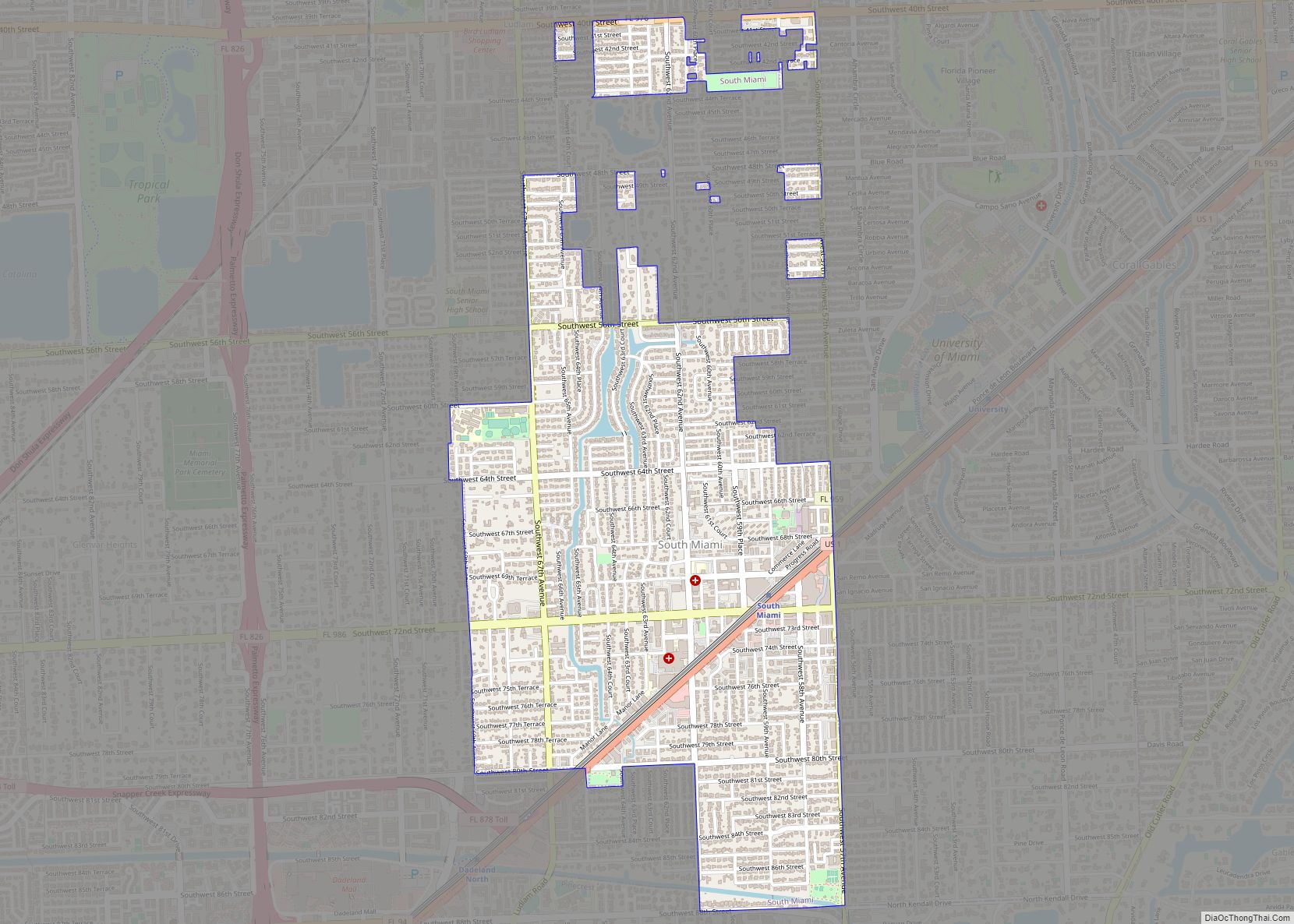
South Miami is a city in Miami-Dade County, Florida, United States, in the Miami metropolitan area. The population was 12,026 as of the 2020 census. South Miami city overview: Name: South Miami city LSAD Code: 25 LSAD Description: city (suffix) State: Florida County: Miami-Dade County Incorporated: June 24, 1927 Elevation: 10 ft (3 m) Total Area: 2.31 sq mi … Read more

Map of South Miami Heights CDP

Map of South Miami Heights CDP

South Miami Heights is a census-designated place (CDP), originally known as Eureka, in Miami-Dade County, Florida. The population was 36,770 as of the 2020 census. South Miami Heights CDP overview: Name: South Miami Heights CDP LSAD Code: 57 LSAD Description: CDP (suffix) State: Florida County: Miami-Dade County Elevation: 10 ft (3 m) Total Area: 4.98 sq mi (12.91 km²) Land … Read more

Map of South Highpoint CDP

Map of South Highpoint CDP

South Highpoint is a census-designated place (CDP) in Pinellas County, Florida, United States. The population was 5,195 at the 2010 census. South Highpoint CDP overview: Name: South Highpoint CDP LSAD Code: 57 LSAD Description: CDP (suffix) State: Florida County: Pinellas County Elevation: 13 ft (4 m) Total Area: 0.85 sq mi (2.21 km²) Land Area: 0.85 sq mi (2.20 km²) Water Area: 0.00 sq mi … Read more

Map of South Pasadena city, Florida

Map of South Pasadena city, Florida

South Pasadena is a city in southern Pinellas County, Florida, United States, near St. Pete Beach and Gulfport. The population was 5,353 at the 2020 census. Gulfport is part of the Tampa–St. Petersburg–Clearwater metropolitan statistical area. South Pasadena city overview: Name: South Pasadena city LSAD Code: 25 LSAD Description: city (suffix) State: Florida County: Pinellas … Read more

Map of South Palm Beach town

Map of South Palm Beach town

South Palm Beach is a town located in Palm Beach County, Florida, United States. The town is situated on a barrier island between the Atlantic Ocean and the Intracoastal Waterway. The entire town is approximately 5⁄8 of a mile (1.0 km) long along South Ocean Boulevard (Florida State Road A1A), its only street. It is between … Read more

Map of South Patrick Shores CDP

Map of South Patrick Shores CDP

South Patrick Shores is a census-designated place (CDP) in Brevard County, Florida, United States. The population was 5,875 at the 2010 census. It is part of the Palm Bay–Melbourne–Titusville Metropolitan Statistical Area. South Patrick Shores CDP overview: Name: South Patrick Shores CDP LSAD Code: 57 LSAD Description: CDP (suffix) State: Florida County: Brevard County Elevation: … Read more

Map of Southchase CDP

Map of Southchase CDP

Southchase is a census-designated place and an unincorporated area in Orange County, Florida, United States. The population was 15,921 at the 2010 census. It is part of the Orlando–Kissimmee–Sanford, Florida Metropolitan Statistical Area. Southchase CDP overview: Name: Southchase CDP LSAD Code: 57 LSAD Description: CDP (suffix) State: Florida County: Orange County Elevation: 89 ft (27 m) Total … Read more

Map of South Venice CDP

Map of South Venice CDP

South Venice is a census-designated place (CDP) in Sarasota County, Florida, United States. The population was 13,949 at the 2010 census. It is part of the Bradenton–Sarasota–Venice Metropolitan Statistical Area. South Venice CDP overview: Name: South Venice CDP LSAD Code: 57 LSAD Description: CDP (suffix) State: Florida County: Sarasota County Elevation: 13 ft (4 m) Total Area: … Read more

Map of South Sarasota CDP

Map of South Sarasota CDP

South Sarasota is a census-designated place (CDP) in Sarasota County, Florida, United States. The population was 4,950 at the 2010 census. It is part of the Bradenton–Sarasota–Venice Metropolitan Statistical Area. South Sarasota CDP overview: Name: South Sarasota CDP LSAD Code: 57 LSAD Description: CDP (suffix) State: Florida County: Sarasota County Elevation: 13 ft (4 m) Total Area: … Read more

Map of Southwest Ranches town

Map of Southwest Ranches town

Southwest Ranches is a town in Broward County, Florida, United States. It is a suburban community part of the Miami metropolitan area and is located on the eastern edge of the Everglades, 15 miles (24 km) southwest of Fort Lauderdale and about 22 miles (35 km) northwest of Miami. It is unusual in that it consists of … Read more

Map of Southgate CDP

Map of Southgate CDP, Florida

Southgate is a census-designated place (CDP) in Sarasota County, Florida, United States. The population was 7,173 at the 2010 census. It is part of the Bradenton–Sarasota–Venice Metropolitan Statistical Area. Southgate CDP overview: Name: Southgate CDP LSAD Code: 57 LSAD Description: CDP (suffix) State: Florida County: Sarasota County Elevation: 0 ft (0 m) Total Area: 1.74 sq mi (4.50 km²) Land … Read more

Map of Southeast Arcadia CDP

Map of Southeast Arcadia CDP

Southeast Arcadia is a census-designated place (CDP) in DeSoto County, Florida, United States. The population was 6,554 at the 2010 census. Southeast Arcadia CDP overview: Name: Southeast Arcadia CDP LSAD Code: 57 LSAD Description: CDP (suffix) State: Florida County: DeSoto County Total Area: 7.24 sq mi (18.75 km²) Land Area: 7.24 sq mi (18.75 km²) Water Area: 0.00 sq mi (0.00 km²) Total Population: … Read more