Map of Spring Lake CDP

Map of Spring Lake CDP, Florida

Spring Lake is an unincorporated community and census-designated place (CDP) in Hernando County, Florida, United States. The population was 458 at the 2010 census, up from 327 at the 2000 census. Spring Lake CDP overview: Name: Spring Lake CDP LSAD Code: 57 LSAD Description: CDP (suffix) State: Florida County: Hernando County Elevation: 310 ft (90 m) Total … Read more

Map of Spring Hill CDP

Map of Spring Hill CDP, Florida

Spring Hill is a census-designated place (CDP) in Hernando County, Florida, United States. The population was 113,568 at the 2020 census, up from 98,621 at the 2010 census. Spring Hill belongs to Florida’s Nature Coast region and is in the Tampa-St. Petersburg-Clearwater metro area. It is east of Hernando Beach, southwest of Brooksville, and north … Read more

Map of Spring Ridge CDP

Map of Spring Ridge CDP, Florida

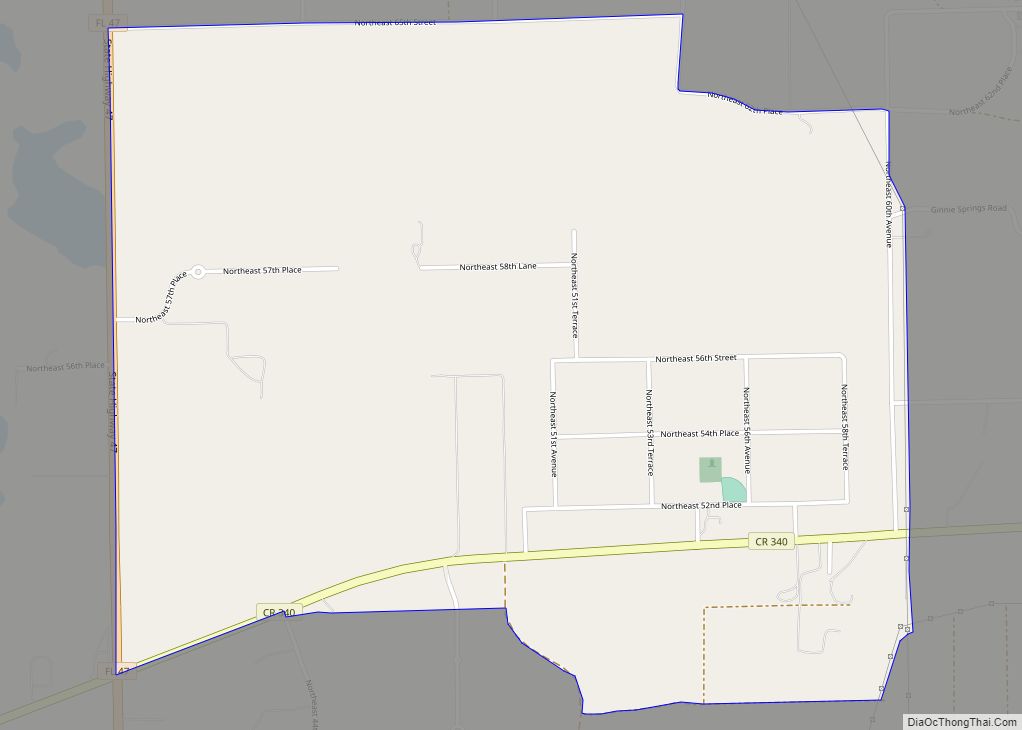
Spring Ridge is an unincorporated community and census-designated place (CDP) in Gilchrist County, Florida, United States. The population was 442 at the 2020 census. Spring Ridge CDP overview: Name: Spring Ridge CDP LSAD Code: 57 LSAD Description: CDP (suffix) State: Florida County: Gilchrist County Elevation: 50 ft (20 m) Total Area: 3.21 sq mi (8.32 km²) Land Area: 3.21 sq mi (8.32 km²) … Read more

Map of St. Augustine Beach city

Map of St. Augustine Beach city

St. Augustine Beach is a city in St. Johns County, Florida, United States. The population was 6,176 at the 2010 census. As of 2018, the population estimated by the U.S. Census Bureau was 7,026. St. Augustine Beach city overview: Name: St. Augustine Beach city LSAD Code: 25 LSAD Description: city (suffix) State: Florida County: St. … Read more

Map of Springhill CDP

Map of Springhill CDP, Florida

Spring Hill (also known as Springhill) is an unincorporated community and census-designated place in Santa Rosa County, Florida, United States. Its population was 160 as of the 2010 census. Springhill CDP overview: Name: Springhill CDP LSAD Code: 57 LSAD Description: CDP (suffix) State: Florida County: Santa Rosa County Elevation: 200 ft (60 m) Total Area: 12.523 sq mi (32.43 km²) … Read more

Map of Springfield city, Florida

Map of Springfield city, Florida

Springfield is a city in Bay County, Florida, United States, east of Panama City. The population was 8,903 at the 2010 census. It is part of the Panama City–Lynn Haven–Panama City Beach Metropolitan Statistical Area. Springfield was incorporated on February 12, 1935. Unlike much of Bay County, Springfield has been mostly left out of the … Read more

Map of St. Cloud city

Map of St. Cloud city, Florida

St. Cloud or Saint Cloud is a city in northern Osceola County, Florida, United States. It is on the southern shore of East Lake Tohopekaliga in Central Florida, about 26 miles (41.8 km) southeast of Orlando. The population was 35,183 in the 2010 census, and 54,579 in the 2019 census estimate. The city is part of … Read more

Map of St. Augustine South CDP

Map of St. Augustine South CDP

St. Augustine South is a census-designated place (CDP) in St. Johns County, Florida, United States. The population was 5,035 at the 2000 census. St. Augustine South CDP overview: Name: St. Augustine South CDP LSAD Code: 57 LSAD Description: CDP (suffix) State: Florida County: St. Johns County Elevation: 30 ft (9 m) Total Area: 1.58 sq mi (4.11 km²) Land Area: … Read more

Map of St. Augustine Shores CDP

Map of St. Augustine Shores CDP

St. Augustine Shores is a census-designated place (CDP) in St. Johns County, Florida, United States. As of the 2000 census, the CDP population was 4,922. St. Augustine Shores CDP overview: Name: St. Augustine Shores CDP LSAD Code: 57 LSAD Description: CDP (suffix) State: Florida County: St. Johns County Elevation: 26 ft (8 m) Total Area: 4.48 sq mi (11.60 km²) … Read more

Map of St. Leo town

Map of St. Leo town, Florida

St. Leo is a town in Pasco County, Florida, United States. It is a suburb included in the Tampa-St. Petersburg-Clearwater, Florida Metropolitan Statistical Area. The population was 1,340 at the 2010 census. It is best known as the home of St. Leo University, Holy Name Monastery and St. Leo Abbey. Vincent D’Ambrosio currently serves as … Read more

Map of St. James City CDP

Map of St. James City CDP

St. James City is an unincorporated community and census-designated place (CDP) on Pine Island in Lee County, Florida, United States. The population was 3,876 at the 2020 census, up from 3,784 at the 2010 census. It is part of the Cape Coral-Fort Myers, Florida Metropolitan Statistical Area. St. James City CDP overview: Name: St. James … Read more

Map of St. George Island CDP

Map of St. George Island CDP, Florida

St. George Island is an island and Census-designated place (CDP) off the Florida Panhandle in the northern Gulf of Mexico. It is in Franklin County, Florida, United States. St. George Island CDP overview: Name: St. George Island CDP LSAD Code: 57 LSAD Description: CDP (suffix) State: Florida ZIP code: 32328 Area code: 850 FIPS code: … Read more