Map of Warm Mineral Springs CDP

Map of Warm Mineral Springs CDP

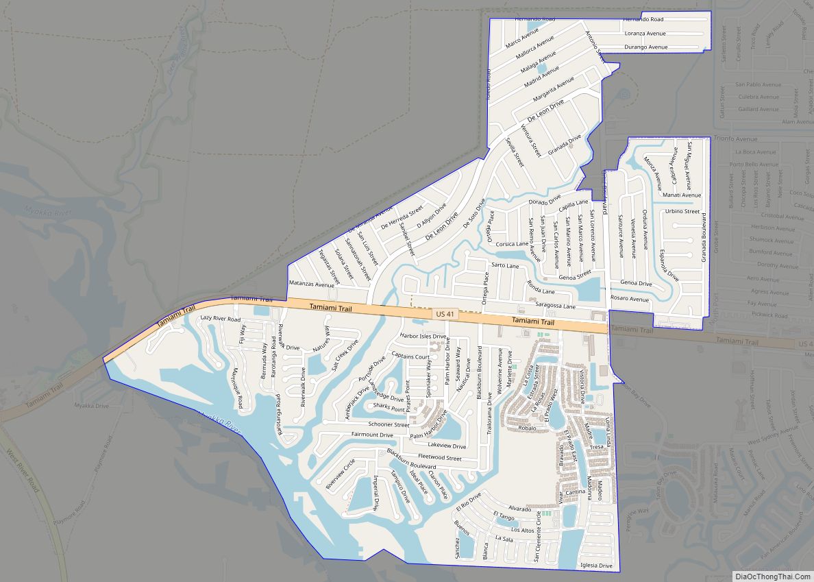
Warm Mineral Springs is a census-designated place (CDP) in Sarasota County, Florida, United States. The population was 5,061 at the 2010 census. It is part of the Bradenton–Sarasota–Venice Metropolitan Statistical Area. The Warm Mineral Springs locale is notable for a free-flowing artesian spring. A large portion of the area was annexed by the municipality of … Read more

Map of Wallace CDP, Florida

Map of Wallace CDP, Florida

Wallace is an unincorporated community and census-designated place in Santa Rosa County, Florida, United States. Its population was 1,785 as of the 2010 census. Wallace CDP overview: Name: Wallace CDP LSAD Code: 57 LSAD Description: CDP (suffix) State: Florida County: Santa Rosa County Elevation: 180 ft (50 m) Total Area: 11.751 sq mi (30.43 km²) Land Area: 11.716 sq mi (30.34 km²) Water … Read more

Map of Warrington CDP

Map of Warrington CDP

Warrington is a census-designated place (CDP) in Escambia County, Florida, United States. Warrington is located between downtown Pensacola and the state line with Alabama; it is 6 miles (10 km) away from both. The population was 14,531 at the 2010 census. It is part of the Pensacola–Ferry Pass–Brent Metropolitan Statistical Area. A failed referendum was held … Read more

Map of Watertown CDP, Florida

Map of Watertown CDP, Florida

Watertown is a census-designated place (CDP) in Columbia County, Florida, United States. As of the 2010 census, it had a population of 2,829. Watertown CDP overview: Name: Watertown CDP LSAD Code: 57 LSAD Description: CDP (suffix) State: Florida County: Columbia County Elevation: 184 ft (56 m) Total Area: 2.53 sq mi (6.55 km²) Land Area: 2.48 sq mi (6.42 km²) Water Area: 0.05 sq mi … Read more

Map of Watergate CDP

Map of Watergate CDP

Watergate is a census-designated place in Palm Beach County, Florida, United States. Its population was 3,459 as of the 2020 census. Watergate is located on the west side of U.S. Route 441, west of Boca Raton. Watergate CDP overview: Name: Watergate CDP LSAD Code: 57 LSAD Description: CDP (suffix) State: Florida County: Palm Beach County … Read more

Map of Washington Park CDP, Florida

Map of Washington Park CDP, Florida

Washington Park is a census-designated place (CDP) in Broward County, Florida, United States. Its population was 1,948 at the 2020 census. Washington Park CDP overview: Name: Washington Park CDP LSAD Code: 57 LSAD Description: CDP (suffix) State: Florida County: Broward County Elevation: 3 ft (1 m) Total Area: 0.26 sq mi (0.67 km²) Land Area: 0.26 sq mi (0.67 km²) Water Area: 0.00 sq mi … Read more

Map of Wausau town

Map of Wausau town, Florida

Wausau is a town in Washington County, Florida, United States. The population was 383 at the 2010 census. Wausau town overview: Name: Wausau town LSAD Code: 43 LSAD Description: town (suffix) State: Florida County: Washington County Elevation: 95 ft (29 m) Total Area: 1.15 sq mi (2.98 km²) Land Area: 1.15 sq mi (2.98 km²) Water Area: 0.00 sq mi (0.00 km²) Total Population: 371 Population … Read more

Map of Waukeenah CDP

Map of Waukeenah CDP

Waukeenah is an unincorporated community and census-designated place (CDP) in Jefferson County, Florida, United States. As of the 2020 census, the population was 259. Waukeenah CDP overview: Name: Waukeenah CDP LSAD Code: 57 LSAD Description: CDP (suffix) State: Florida County: Jefferson County Elevation: 194 ft (59 m) Total Area: 3.22 sq mi (8.35 km²) Land Area: 3.16 sq mi (8.18 km²) Water Area: … Read more

Map of Wauchula city

Map of Wauchula city

Wauchula is a city and the county seat of Hardee County, Florida, United States. As of the 2010 census it had a population of 5,001, up from 4,368 at the 2000 census. Wauchula has been called the “cucumber capital of the world”, although citrus has become a more important agricultural crop over the past few … Read more

Map of Wedgefield CDP

Map of Wedgefield CDP, Florida

Wedgefield is a census-designated place and an unincorporated area in Orange County, Florida, United States. The population was 6,705 at the 2010 census, up from 2,700 at the 2000 census. It is part of the Orlando–Kissimmee Metropolitan Statistical Area. Wedgefield CDP overview: Name: Wedgefield CDP LSAD Code: 57 LSAD Description: CDP (suffix) State: Florida County: … Read more

Map of Webster city

Map of Webster city, Florida

Webster is a city located in Sumter County, Florida, United States. As of the 2020 census, the city had a total population of 778. According to the U.S. Census Bureau’s 2018 estimates, the town had a population of 1,114. The ZIP Code for this city is 33597, which is shared by Oak Grove, St. Catherine, … Read more

Map of Waverly CDP, Florida

Map of Waverly CDP, Florida

Waverly is a census-designated place (CDP) in east-central Polk County, Florida, United States. The population was 1,927 at the 2000 census. It is part of the Lakeland–Winter Haven Metropolitan Statistical Area. Waverly CDP overview: Name: Waverly CDP LSAD Code: 57 LSAD Description: CDP (suffix) State: Florida County: Polk County Elevation: 128 ft (39 m) Total Area: 1.52 sq mi … Read more