Map of Parker city, Idaho

Map of Parker city, Idaho

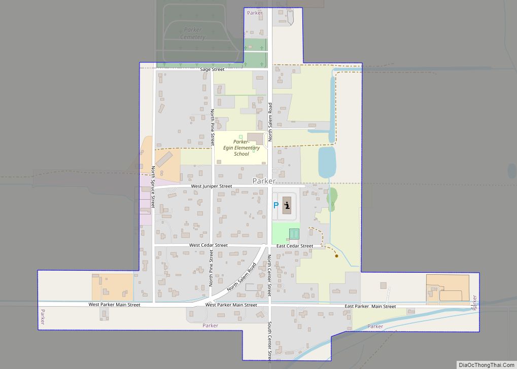
Parker is a city in southeastern Fremont County, Idaho, United States. The population was 305 at the 2010 census. It is part of the Rexburg, Idaho Micropolitan Statistical Area. Parker city overview: Name: Parker city LSAD Code: 25 LSAD Description: city (suffix) State: Idaho County: Fremont County Elevation: 4,928 ft (1,502 m) Total Area: 0.35 sq mi (0.90 km²) Land … Read more

Map of Payette city

Map of Payette city

Payette is a city in and the county seat of Payette County, Idaho, United States. The population was 7,433 at the 2010 census. It is part of the Ontario, OR−ID Micropolitan Statistical Area. Payette city overview: Name: Payette city LSAD Code: 25 LSAD Description: city (suffix) State: Idaho County: Payette County Elevation: 2,149 ft (655 m) Total … Read more

Map of Paul city

Map of Paul city

Paul is a city in Minidoka County, Idaho, founded in 1907. The population was 1,195 at the 2020 census. It is part of the Burley, Idaho Micropolitan Statistical Area. The town received its name from Charles H. Paul, an engineer who worked on the Minidoka Project. Paul city overview: Name: Paul city LSAD Code: 25 … Read more

Map of Parma city

Map of Parma city, Idaho

Parma is a city in Canyon County, Idaho, United States. The population was 1,983 at the 2010 census, up from 1,771 in 2000. It is the fourth largest city in the county (behind Middleton, Caldwell, and Nampa all in the county’s eastern portion) and the largest in the rural western portion. It is part of … Read more

Map of Parkline CDP

Map of Parkline CDP

Parkline is an unincorporated census-designated place on the Coeur d’Alene Reservation in Benewah County, Idaho, United States. The population was 80 at the 2010 census. Parkline was a city until it disincorporated in 2001. Parkline CDP overview: Name: Parkline CDP LSAD Code: 57 LSAD Description: CDP (suffix) State: Idaho County: Benewah County Elevation: 2,205 ft (672 m) … Read more

Map of Plummer city

Map of Plummer city, Idaho

Plummer is a city in Benewah County, Idaho, United States. The population was 1,044 at the 2010 census, up from 990 in 2000. It is the largest city within the Coeur d’Alene Reservation, and is accessed by U.S. Route 95, the state’s primary north–south highway. Plummer city overview: Name: Plummer city LSAD Code: 25 LSAD … Read more

Map of Placerville city, Idaho

Map of Placerville city, Idaho

Placerville is a populated place in Boise County, Idaho, United States. The population was 53 at the 2010 census. It is part of the Boise City–Nampa, Idaho Metropolitan Statistical Area. Placerville city overview: Name: Placerville city LSAD Code: 25 LSAD Description: city (suffix) State: Idaho County: Boise County Elevation: 4,324 ft (1,318 m) Total Area: 1.00 sq mi (2.59 km²) … Read more

Map of Pinehurst city, Idaho

Map of Pinehurst city, Idaho

Pinehurst is a city in Shoshone County, Idaho, United States. Located at the west end of the Silver Valley mining region, its population was 1,619 at the 2010 census. Pinehurst city overview: Name: Pinehurst city LSAD Code: 25 LSAD Description: city (suffix) State: Idaho County: Shoshone County Elevation: 2,224 ft (678 m) Total Area: 1.00 sq mi (2.58 km²) Land … Read more

Map of Pierce city, Idaho

Map of Pierce city, Idaho

Pierce is a city in the northwest United States, located in Clearwater County, Idaho. The population was 508 at the 2010 census, down from 617 in 2000. Pierce city overview: Name: Pierce city LSAD Code: 25 LSAD Description: city (suffix) State: Idaho County: Clearwater County Elevation: 3,094 ft (943 m) Total Area: 0.82 sq mi (2.14 km²) Land Area: 0.82 sq mi (2.14 km²) … Read more

Map of Peck city

Map of Peck city, Idaho

Peck is a city in Nez Perce County, Idaho, United States. The population was 197 at the 2010 census. It is part of the Lewiston, ID-WA Metropolitan Statistical Area. Many residents of Peck work in nearby Orofino, Idaho. Additionally, Peck residents attend high school in Orofino since Peck does not have a high school. Peck … Read more

Map of Preston city, Idaho

Map of Preston city, Idaho

Preston is a city in Franklin County, Idaho, United States. The population was 5,204 at the 2010 census. The city is the county seat of Franklin County. It is part of the Logan, Utah-Idaho Metropolitan Statistical Area. Preston city overview: Name: Preston city LSAD Code: 25 LSAD Description: city (suffix) State: Idaho County: Franklin County … Read more

Map of Potlatch city

Map of Potlatch city

Potlatch is a city in the northwest United States, located in north central Idaho in Latah County, about six miles (10 km) east of the border with Washington. On the Palouse north of Moscow, it is served by State Highway 6, and bordered on the northeast by the small community of Onaway. The population of Potlatch … Read more