Map of Broadview village, Illinois
Broadview is a village in Cook County, Illinois, 12 miles (19 km) west of downtown Chicago. As of the 2020 census it had a population of 7,998. Broadview village overview: Name: Broadview village LSAD Code: 47 LSAD Description: village (suffix) State: Illinois County: Cook County Incorporated: 1914 Total Area: 1.78 sq mi (4.60 km²) Land Area: 1.78 sq mi (4.60 km²) Water ... Read more
Map of Broadview village, Illinois
Map of Broadlands village, Illinois
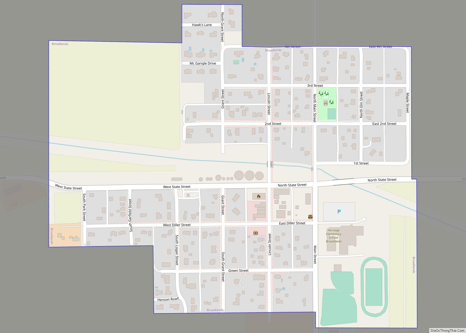
Broadlands is a village in Champaign County, Illinois, along the East Branch of the Embarras River. The population was 316 at the 2020 census. Originally owned by the Sullivant family, Broadlands was, at over 70,000 acres (280 km), one of the world’s largest farms in the late 1860s. Broadlands was sold to John T. Alexander in ... Read more
Map of Broadlands village, Illinois
Map of Brimfield village, Illinois
Brimfield (formerly Charleston) is a village in Peoria County, Illinois, United States. The population was 868 at the 2010 census. Brimfield is part of the Peoria, Illinois Metropolitan Statistical Area. Brimfield village overview: Name: Brimfield village LSAD Code: 47 LSAD Description: village (suffix) State: Illinois County: Peoria County Total Area: 0.83 sq mi (2.14 km²) Land Area: 0.82 sq mi ... Read more
Map of Brimfield village, Illinois
Map of Buckingham village, Illinois
Buckingham is a village in Kankakee County, Illinois, United States. The population was 300 at the 2010 census, up from 237 at the 2000 census. The village is about 63.7 miles south west of Chicago Illinois. It is included in the Kankakee–Bradley, Illinois Metropolitan Statistical Area. The Coal Branch line of the Kankakee and Southwestern ... Read more
Map of Buckingham village, Illinois
Map of Bryant village, Illinois
Bryant is a village in Fulton County, Illinois, United States. The population was 220 at the 2010 census, down from 255 at the 2000 census. Bryant village overview: Name: Bryant village LSAD Code: 47 LSAD Description: village (suffix) State: Illinois County: Fulton County Elevation: 620 ft (190 m) Total Area: 0.25 sq mi (0.64 km²) Land Area: 0.25 sq mi (0.64 km²) Water ... Read more
Map of Bryant village, Illinois
Map of Brussels village
Brussels is a village in southern Calhoun County, Illinois, United States. The population was 116 at the 2020 census. Brussels village overview: Name: Brussels village LSAD Code: 47 LSAD Description: village (suffix) State: Illinois County: Calhoun County Elevation: 515 ft (157 m) Total Area: 0.558 sq mi (1.45 km²) Land Area: 0.558 sq mi (1.45 km²) Water Area: 0.00 sq mi (0.0 km²) Total Population: 116 ... Read more
Map of Brussels village
Map of Brownstown village, Illinois
Brownstown is a village in Fayette County, Illinois, United States. The population was 759 at the 2010 census, up from 705 at the 2000 census. Brownstown village overview: Name: Brownstown village LSAD Code: 47 LSAD Description: village (suffix) State: Illinois County: Fayette County Elevation: 594 ft (181 m) Total Area: 0.76 sq mi (1.97 km²) Land Area: 0.76 sq mi (1.97 km²) Water ... Read more
Map of Brownstown village, Illinois
Map of Browns village
Browns is a village in Edwards County, Illinois, United States. The population was 139 as of the 2020 census, slightly up from 134 as of the 2010 census. Browns village overview: Name: Browns village LSAD Code: 47 LSAD Description: village (suffix) State: Illinois County: Edwards County Elevation: 397 ft (121 m) Total Area: 0.29 sq mi (0.75 km²) Land Area: ... Read more
Map of Browns village
Map of Browning village, Illinois
Browning is a village in Schuyler County, Illinois, United States. The population was 130 at the 2000 census. Browning village overview: Name: Browning village LSAD Code: 47 LSAD Description: village (suffix) State: Illinois County: Schuyler County Elevation: 440 ft (130 m) Total Area: 0.31 sq mi (0.80 km²) Land Area: 0.31 sq mi (0.80 km²) Water Area: 0.00 sq mi (0.00 km²) Total Population: 117 Population ... Read more
Map of Browning village, Illinois
Map of Broughton village, Illinois
Broughton is a village in Hamilton County, Illinois, United States. The population was 194 at the 2010 census. It is part of the Mount Vernon Micropolitan Statistical Area. The village was founded in the 1720s as Saint Philippe du Grand Marais (called “St. Philippe”) by French coureurs de bois. In the early 19th century, it ... Read more
Map of Broughton village, Illinois
Map of Brookport city
Brookport is a city in Massac County, Illinois, United States. The population was 725 at the 2020 census, down from 984 in 2010. It is part of the Paducah, KY-IL Micropolitan Statistical Area. Brookport city overview: Name: Brookport city LSAD Code: 25 LSAD Description: city (suffix) State: Illinois County: Massac County Elevation: 340 ft (100 m) Total ... Read more
Map of Brookport city
Map of Brooklyn village, Illinois
Brooklyn (popularly known as Lovejoy), is a village in St. Clair County, Illinois, United States. Located two miles north of East St. Louis, Illinois and three miles northeast of downtown St. Louis, Missouri, it is the oldest town incorporated by African Americans in the United States. Its motto is “Founded by Chance, Sustained by Courage.” ... Read more
Map of Brooklyn village, Illinois