Map of Adeline village

Map of Adeline village

Adeline is a village in Maryland Township, Ogle County, Illinois, United States, along the Leaf River. The population was 85 at the 2010 census, down from 139 in 2000. Adeline village overview: Name: Adeline village LSAD Code: 47 LSAD Description: village (suffix) State: Illinois County: Ogle County Elevation: 797 ft (243 m) Total Area: 0.27 sq mi (0.69 km²) Land … Read more

Map of Addison village, Illinois

Map of Addison village, Illinois

Addison is a village located in the Chicago Metropolitan Area, in DuPage County, Illinois, United States. The population was 36,942 at the 2010 census. Addison village overview: Name: Addison village LSAD Code: 47 LSAD Description: village (suffix) State: Illinois County: DuPage County Incorporated: 1884 Elevation: 702 ft (214 m) Total Area: 10.00 sq mi (25.90 km²) Land Area: 9.83 sq mi (25.46 km²) … Read more

Map of Addieville village

Map of Addieville village

Addieville is a village in Washington County, Illinois, United States. The population at the time of the 2010 census was 252. Addieville village overview: Name: Addieville village LSAD Code: 47 LSAD Description: village (suffix) State: Illinois County: Washington County Elevation: 469 ft (143 m) Total Area: 0.99 sq mi (2.57 km²) Land Area: 0.99 sq mi (2.57 km²) Water Area: 0.00 sq mi (0.00 km²) Total … Read more

Map of Adair CDP, Illinois

Map of Adair CDP, Illinois

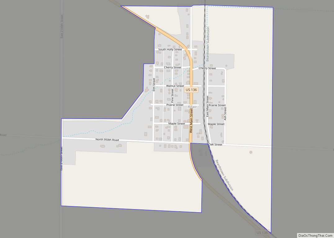
Adair is an unincorporated community and census-designated place (CDP) in McDonough County, Illinois, United States. It is part of New Salem Township. As of the 2020 census, Adair had a population of 212. Adair was laid out in August 1870 under the name of “Reedyville”; though the name has never been officially changed, the location … Read more

Map of Abingdon city

Map of Abingdon city, Illinois

Abingdon is a city in Knox County, Illinois, United States, 50 miles (80 km) west of Peoria. It is part of the Galesburg Micropolitan Statistical Area. The city was first settled in 1828 and was incorporated in 1857. In june of 1907, the patent for the common spring-loaded mousetrap was awarded to William Hooker William Armstrong … Read more

Map of Algonquin village

Map of Algonquin village, Illinois

Algonquin is a village in McHenry and Kane counties, Illinois, in the United States. It is a suburb of Chicago, located approximately 40 miles (64 km) northwest of the Loop. As of the 2020 census, the village’s population was 29,700. The village is known as “The Gem of the Fox River Valley”, referring to the location … Read more

Map of Alexis village

Map of Alexis village

Alexis is a village in Mercer and Warren counties in Illinois, United States. The population was 793 at the 2020 census. The Mercer County portion is part of the Davenport–Moline–Rock Island, IA-IL Metropolitan Statistical Area. Alexis village overview: Name: Alexis village LSAD Code: 47 LSAD Description: village (suffix) State: Illinois County: Mercer County, Warren County … Read more

Map of Alsey village

Map of Alsey village

Alsey is a village in Scott County, Illinois, USA. The population was 246 at the 2000 census. It is part of the Jacksonville Micropolitan Statistical Area. Alsey village overview: Name: Alsey village LSAD Code: 47 LSAD Description: village (suffix) State: Illinois County: Scott County Elevation: 630 ft (190 m) Total Area: 0.56 sq mi (1.45 km²) Land Area: 0.55 sq mi (1.42 km²) … Read more

Map of Alpha village

Map of Alpha village, Illinois

Alpha is a village in Henry County, Illinois, United States. The population was 671 at the 2010 census, down from 726 in 2000. Alpha village overview: Name: Alpha village LSAD Code: 47 LSAD Description: village (suffix) State: Illinois County: Henry County Total Area: 0.31 sq mi (0.81 km²) Land Area: 0.31 sq mi (0.81 km²) Water Area: 0.00 sq mi (0.00 km²) Total Population: … Read more

Map of Alorton village

Map of Alorton village

Alorton (formerly Alcoa) was a village in St. Clair County, Illinois, United States. Incorporated in 1944, it was one of three municipalities that merged to form the city of Cahokia Heights on May 6, 2021; the other two were the village of Cahokia and the city of Centreville. Prior to merger, Alorton had a population … Read more

Map of Alma village, Illinois

Map of Alma village, Illinois

Alma is a village in Marion County, Illinois, United States. The population was 318 at the 2020 census. Alma village overview: Name: Alma village LSAD Code: 47 LSAD Description: village (suffix) State: Illinois County: Marion County Elevation: 627 ft (191 m) Total Area: 1.13 sq mi (2.93 km²) Land Area: 1.13 sq mi (2.93 km²) Water Area: 0.00 sq mi (0.00 km²) Total Population: 318 Population … Read more

Map of Allerton village, Illinois

Map of Allerton village, Illinois

Allerton is a village in Sidell Township, Vermilion County, Illinois, United States. A small portion of the village extends into Champaign County. The population was 262 at the 2020 census. Allerton village overview: Name: Allerton village LSAD Code: 47 LSAD Description: village (suffix) State: Illinois County: Champaign County, Vermilion County Elevation: 699 ft (213 m) Total Area: … Read more