Map of Clifton village, Illinois

Map of Clifton village, Illinois

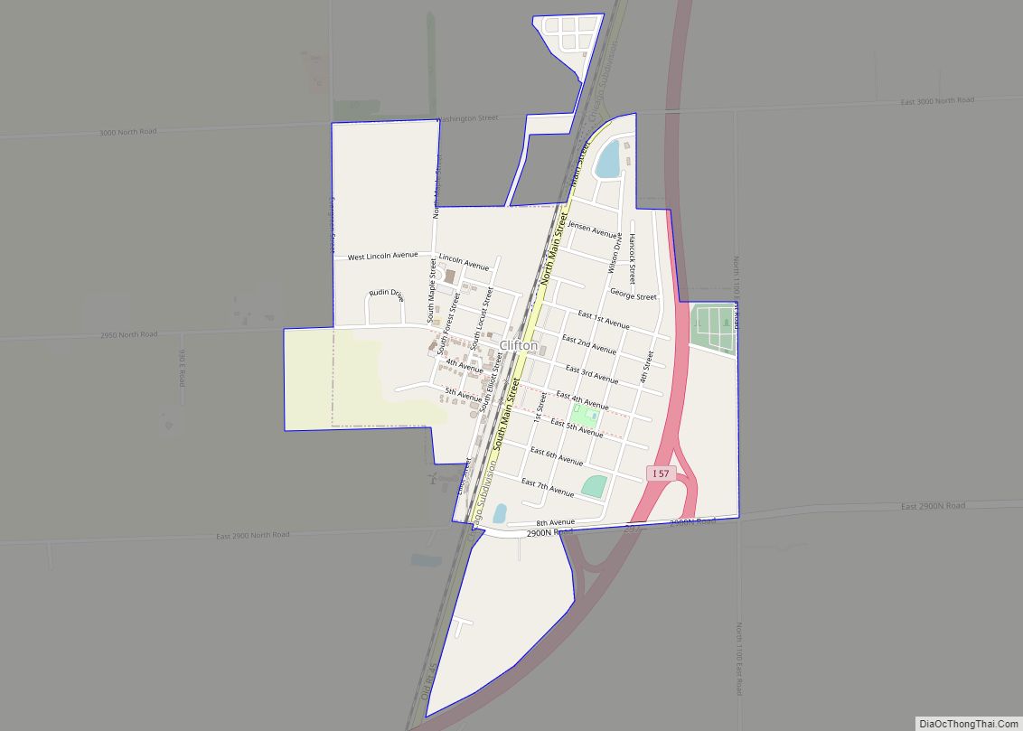
Clifton is a village in Chebanse Township, Iroquois County, Illinois, United States. The population was 1,468 at the 2010 census, up from 1,317 at the 2000 census. Clifton village overview: Name: Clifton village LSAD Code: 47 LSAD Description: village (suffix) State: Illinois County: Iroquois County Elevation: 669 ft (204 m) Total Area: 0.93 sq mi (2.41 km²) Land Area: 0.93 sq mi … Read more

Map of Coal Valley village

Map of Coal Valley village

The village of Coal Valley is located in both Rock Island County and Henry County in the U.S. state of Illinois. The population was 3,743 at the 2010 census, up from 3,606 in 2000. It is mostly residential, housing families who work in or out of the greater Quad Cities Area and is considered a … Read more

Map of Coal City village

Map of Coal City village, Illinois

Coal City is a village in Grundy and Will Counties in the U.S. state of Illinois. It is considered a fringe town of the Chicago metropolitan area. The population was 5,587 at the 2010 census. It is served by Interstate 55. The Santa Fe Railway formerly served Coal City at Coal City Station. Coal City … Read more

Map of Coatsburg village

Map of Coatsburg village

Coatsburg is a village in Adams County, Illinois, United States. The population was 150 at the 2020 census. It is part of the Quincy, IL–MO Micropolitan Statistical Area. Coatsburg village overview: Name: Coatsburg village LSAD Code: 47 LSAD Description: village (suffix) State: Illinois County: Adams County Elevation: 761 ft (232 m) Total Area: 0.13 sq mi (0.34 km²) Land Area: … Read more

Map of Coalton village

Map of Coalton village, Illinois

Coalton is a village in Montgomery County, Illinois, United States. The population was 317 at the 2020 census. Coalton village overview: Name: Coalton village LSAD Code: 47 LSAD Description: village (suffix) State: Illinois County: Montgomery County Elevation: 676 ft (206 m) Total Area: 0.53 sq mi (1.37 km²) Land Area: 0.53 sq mi (1.37 km²) Water Area: 0.00 sq mi (0.00 km²) Total Population: 317 Population … Read more

Map of Coffeen city

Map of Coffeen city

Coffeen is a small city in Montgomery County, Illinois, United States. The population was 647 at the 2020 census. Coffeen city overview: Name: Coffeen city LSAD Code: 25 LSAD Description: city (suffix) State: Illinois County: Montgomery County Elevation: 630 ft (190 m) Total Area: 1.16 sq mi (3.01 km²) Land Area: 1.16 sq mi (3.01 km²) Water Area: 0.00 sq mi (0.00 km²) Total Population: 647 … Read more

Map of Cobden village

Map of Cobden village, Illinois

Cobden is a village in Union County, Illinois, United States, within the Southern Illinois region informally known as “Little Egypt.” The population as of the 2020 census is 1,034, a decline of 10.63% since the 2010 census. Cobden is regionally known for the mascot of its public school district, Cobden Unit School District #17, called … Read more

Map of Coleta village

Map of Coleta village

Coleta is a village in Whiteside County, Illinois, United States. The population was 164 at the 2010 census, up from 155 in 2000. Coleta village overview: Name: Coleta village LSAD Code: 47 LSAD Description: village (suffix) State: Illinois County: Whiteside County Total Area: 0.37 sq mi (0.96 km²) Land Area: 0.37 sq mi (0.96 km²) Water Area: 0.00 sq mi (0.00 km²) Total Population: … Read more

Map of Colchester city, Illinois

Map of Colchester city, Illinois

Colchester is a city in McDonough County, Illinois, United States. The population was 1,108 at the 2020 census, down from 1,401 in 2010. The city is named after the town of Colchester, England. Colchester city overview: Name: Colchester city LSAD Code: 25 LSAD Description: city (suffix) State: Illinois County: McDonough County Elevation: 697 ft (212 m) Total … Read more

Map of Collinsville city, Illinois

Map of Collinsville city, Illinois

Collinsville is a city located mainly in Madison County and partially in St. Clair County, Illinois, United States. As of the 2020 census, the city had a population of 24,366. Collinsville is approximately 14 miles (23 km) east of St. Louis, Missouri, and is part of that city’s Metro East area. Collinsville is the location of … Read more

Map of Colfax village, Illinois

Map of Colfax village, Illinois

Colfax is a village in McLean County, Illinois, United States. The population was 996 at the 2020 census. It is part of the Bloomington–Normal Metropolitan Statistical Area. Colfax village overview: Name: Colfax village LSAD Code: 47 LSAD Description: village (suffix) State: Illinois County: McLean County Elevation: 755 ft (230 m) Total Area: 0.55 sq mi (1.43 km²) Land Area: 0.55 sq mi … Read more

Map of Colp village

Map of Colp village

Colp is a village in Williamson County, Illinois, United States. The population was 225 at the 2010 census. Colp village overview: Name: Colp village LSAD Code: 47 LSAD Description: village (suffix) State: Illinois County: Williamson County Elevation: 394 ft (120 m) Total Area: 0.13 sq mi (0.35 km²) Land Area: 0.13 sq mi (0.35 km²) Water Area: 0.00 sq mi (0.00 km²) Total Population: 168 Population … Read more