Map of Colona city, Illinois

Map of Colona city, Illinois

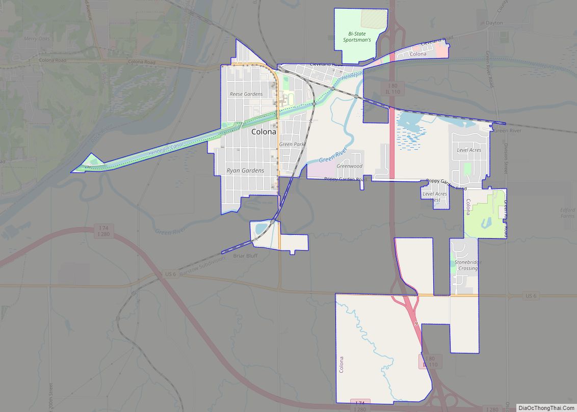
Colona is a city in Henry County, Illinois, along the Green River. It is part of the Quad Cities metropolitan area. The population was 5,307 at the 2020 census, up from 5,099 at the 2010 census. The City of Colona was created in 1997 by the merger of the former City of Green Rock and … Read more

Map of Columbus village, Illinois

Map of Columbus village, Illinois

Columbus is a village in Adams County, Illinois, United States. The population was 114 at the 2020 census. It is part of the Quincy, IL–MO Micropolitan Statistical Area. Columbus village overview: Name: Columbus village LSAD Code: 47 LSAD Description: village (suffix) State: Illinois County: Adams County Elevation: 712 ft (217 m) Total Area: 0.22 sq mi (0.57 km²) Land Area: … Read more

Map of Columbia city, Illinois

Map of Columbia city, Illinois

Columbia is a city mainly in Monroe County with a small portion in St. Clair County in the U.S. state of Illinois, about 12 miles (19 km) south of St. Louis, Missouri. The population was 10,999 at the 2020 census. Columbia city overview: Name: Columbia city LSAD Code: 25 LSAD Description: city (suffix) State: Illinois County: … Read more

Map of Compton village, Illinois

Map of Compton village, Illinois

Compton is a village in Brooklyn Township, Lee County, Illinois, United States. The population was 303 at the 2010 census, down from 347 in 2000. Compton village overview: Name: Compton village LSAD Code: 47 LSAD Description: village (suffix) State: Illinois County: Lee County Founded: 1875 Elevation: 974 ft (297 m) Total Area: 0.17 sq mi (0.43 km²) Land Area: 0.17 sq mi … Read more

Map of Como CDP

Map of Como CDP, Illinois

Como is a census-designated place in Whiteside County, Illinois, United States. Its population was 567 as of the 2010 census. Como CDP overview: Name: Como CDP LSAD Code: 57 LSAD Description: CDP (suffix) State: Illinois County: Whiteside County Elevation: 630 ft (190 m) Total Area: 1.15 sq mi (2.99 km²) Land Area: 1.07 sq mi (2.76 km²) Water Area: 0.09 sq mi (0.23 km²) Total Population: … Read more

Map of Congerville village

Map of Congerville village

Congerville is a village in Woodford County, Illinois, United States. The population was 474 as of the 2010 census, up from 466 in 2000. Congerville is part of the Peoria, Illinois Metropolitan Statistical Area. Congerville village overview: Name: Congerville village LSAD Code: 47 LSAD Description: village (suffix) State: Illinois County: Woodford County Elevation: 745 ft (227 m) … Read more

Map of Concord village, Illinois

Map of Concord village, Illinois

Concord is a village in Morgan County, Illinois, United States. The population was 150 at the 2020 census. It is part of the Jacksonville Micropolitan Statistical Area. Concord village overview: Name: Concord village LSAD Code: 47 LSAD Description: village (suffix) State: Illinois County: Morgan County Elevation: 591 ft (180 m) Total Area: 0.25 sq mi (0.64 km²) Total Population: 150 … Read more

Map of Cordova village, Illinois

Map of Cordova village, Illinois

Cordova is a village in Rock Island County, Illinois, United States. The population was 672 at the 2010 census, up from 633 in 2000. Cordova village overview: Name: Cordova village LSAD Code: 47 LSAD Description: village (suffix) State: Illinois County: Rock Island County Total Area: 0.57 sq mi (1.49 km²) Land Area: 0.57 sq mi (1.49 km²) Water Area: 0.00 sq mi (0.00 km²) … Read more

Map of Cooksville village

Map of Cooksville village

Cooksville is a village in McLean County, Illinois, United States. The population was 157 at the 2020 census. It is part of the Bloomington–Normal Metropolitan Statistical Area. Cooksville village overview: Name: Cooksville village LSAD Code: 47 LSAD Description: village (suffix) State: Illinois County: McLean County Elevation: 768 ft (234 m) Total Area: 0.22 sq mi (0.56 km²) Land Area: 0.22 sq mi … Read more

Map of Cornland CDP

Map of Cornland CDP

Cornland is an unincorporated community and census-designated place in Logan County, Illinois. As of the 2010 census, its population was 93. Cornland CDP overview: Name: Cornland CDP LSAD Code: 57 LSAD Description: CDP (suffix) State: Illinois County: Logan County Elevation: 604 ft (184 m) Total Area: 0.10 sq mi (0.25 km²) Land Area: 0.10 sq mi (0.25 km²) Water Area: 0.00 sq mi (0.00 km²) Total … Read more

Map of Cornell village

Map of Cornell village, Illinois

Cornell is a village in Livingston County, Illinois, United States. The population was 467 at the 2010 census. Cornell village overview: Name: Cornell village LSAD Code: 47 LSAD Description: village (suffix) State: Illinois County: Livingston County Elevation: 632 ft (193 m) Total Area: 0.65 sq mi (1.69 km²) Land Area: 0.65 sq mi (1.69 km²) Water Area: 0.00 sq mi (0.00 km²) Total Population: 446 Population … Read more

Map of Coulterville village, Illinois

Map of Coulterville village, Illinois

Coulterville is a village in Randolph County, Illinois, United States. The population was 945 as of the 2010 census. Coulterville village overview: Name: Coulterville village LSAD Code: 47 LSAD Description: village (suffix) State: Illinois County: Randolph County Founded: November 19, 1850 Total Area: 0.57 sq mi (1.47 km²) Land Area: 0.57 sq mi (1.47 km²) Water Area: 0.00 sq mi (0.00 km²) Total Population: … Read more