Map of Cortland town

Map of Cortland town, Illinois

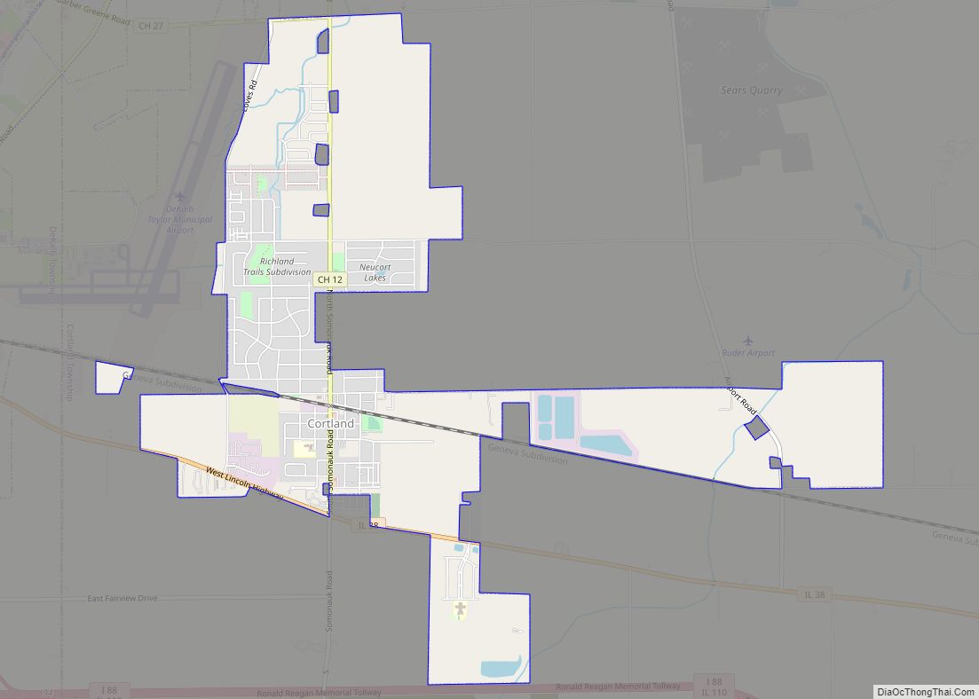
Cortland is an incorporated town in DeKalb County, Illinois, United States. The population was 4,398 at the 2020 Census. It was previously 4,270 at the 2010 census, up from 2,066 in 2000. Because of its status as an incorporated town, Cortland has adopted the slogan, “The Third Largest Town in Illinois”. Only the towns of … Read more

Map of Countryside city

Map of Countryside city, Illinois

Countryside is a city in Cook County, Illinois, United States. Per the 2020 census, the population was 6,420. Countryside city overview: Name: Countryside city LSAD Code: 25 LSAD Description: city (suffix) State: Illinois County: Cook County Incorporated: 1960 Total Area: 2.88 sq mi (7.45 km²) Land Area: 2.88 sq mi (7.45 km²) Water Area: 0.00 sq mi (0.00 km²)  0% Total Population: 6,420 Population … Read more

Map of Country Club Hills city

Map of Country Club Hills city, Illinois

Country Club Hills is a city in Cook County, Illinois, United States. It is a suburb and south of Chicago. The population was 16,775 at the 2020 census. Country Club Hills city overview: Name: Country Club Hills city LSAD Code: 25 LSAD Description: city (suffix) State: Illinois County: Cook County Incorporated: 1958 Total Area: 4.99 sq mi … Read more

Map of Coyne Center CDP

Map of Coyne Center CDP

Coyne Center is a census-designated place (CDP) in Rock Island County, Illinois, United States. The population was 827 at the 2010 census. Coyne Center CDP overview: Name: Coyne Center CDP LSAD Code: 57 LSAD Description: CDP (suffix) State: Illinois County: Rock Island County Total Area: 1.72 sq mi (4.45 km²) Land Area: 1.72 sq mi (4.45 km²) Water Area: 0.00 sq mi (0.00 km²) … Read more

Map of Cowden village

Map of Cowden village

Cowden is a village in Shelby County, Illinois, United States. The population was 629 at the 2010 census. Cowden village overview: Name: Cowden village LSAD Code: 47 LSAD Description: village (suffix) State: Illinois County: Shelby County Elevation: 604 ft (184 m) Total Area: 0.40 sq mi (1.04 km²) Land Area: 0.40 sq mi (1.04 km²) Water Area: 0.00 sq mi (0.00 km²) Total Population: 515 Population … Read more

Map of Crainville village

Map of Crainville village

Crainville is a village in Williamson County, Illinois, United States. The population was 1,254 at the 2010 census. Crainville village overview: Name: Crainville village LSAD Code: 47 LSAD Description: village (suffix) State: Illinois County: Williamson County Elevation: 472 ft (144 m) Total Area: 1.66 sq mi (4.31 km²) Land Area: 1.65 sq mi (4.28 km²) Water Area: 0.01 sq mi (0.03 km²) Total Population: 1,443 Population … Read more

Map of Crab Orchard CDP

Map of Crab Orchard CDP, Illinois

Crab Orchard is an unincorporated census-designated place east of Marion in Williamson County, Illinois, located along an old route of Illinois Route 13 now designated Crab Orchard Road. The upper branches of Crab Orchard Creek which eventually feed into Crab Orchard Lake flow nearby and gave the community its name. For a brief time during … Read more

Map of Crescent City village, Illinois

Map of Crescent City village, Illinois

Crescent City is a village in Iroquois and Crescent townships, Iroquois County, Illinois, United States. The population was 615 at the 2010 census. Crescent City village overview: Name: Crescent City village LSAD Code: 47 LSAD Description: village (suffix) State: Illinois County: Iroquois County Elevation: 640 ft (195 m) Total Area: 0.46 sq mi (1.18 km²) Land Area: 0.46 sq mi (1.18 km²) Water … Read more

Map of Creal Springs city

Map of Creal Springs city

Creal Springs is a city in Williamson County, Illinois, United States. The population was 543 at the 2010 census. Creal Springs city overview: Name: Creal Springs city LSAD Code: 25 LSAD Description: city (suffix) State: Illinois County: Williamson County Elevation: 505 ft (154 m) Total Area: 1.03 sq mi (2.67 km²) Land Area: 1.03 sq mi (2.66 km²) Water Area: 0.00 sq mi (0.01 km²) Total … Read more

Map of Creston village, Illinois

Map of Creston village, Illinois

Creston is a village in Ogle County, Illinois, United States. The population was 627 at the 2020 census, down from 662 in 2010. Creston village overview: Name: Creston village LSAD Code: 47 LSAD Description: village (suffix) State: Illinois County: Ogle County Elevation: 906 ft (276 m) Total Area: 1.15 sq mi (2.97 km²) Land Area: 1.15 sq mi (2.97 km²) Water Area: 0.00 sq mi … Read more

Map of Crest Hill city

Map of Crest Hill city

Crest Hill is a city in Lockport Township, Will County, Illinois, United States. The 2020 census put Crest Hill’s population at 20,459. Crest Hill city overview: Name: Crest Hill city LSAD Code: 25 LSAD Description: city (suffix) State: Illinois County: Will County Incorporated: January 22, 1960 Elevation: 640 ft (200 m) Total Area: 9.18 sq mi (23.79 km²) Land Area: … Read more

Map of Crete village

Map of Crete village, Illinois

Crete is a village in Will County, Illinois, United States. It is a far south suburb of Chicago, 30 miles from the Loop and only 6 miles from the Indiana border. The population was 8,465 at the 2020 census. Originally named Wood’s Corner, it was founded in 1836 by Vermonters Dyantha and Willard Wood. Crete … Read more