Map of Hainesville village
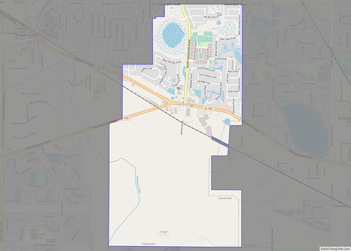
Hainesville is a village in Avon Township, Lake County, Illinois, United States. Per the 2020 census, the population was 3,546. Hainesville has the distinction of being the oldest incorporated community within Lake County. Hainesville village overview: Name: Hainesville village LSAD Code: 47 LSAD Description: village (suffix) State: Illinois County: Lake County Total Area: 1.88 sq mi (4.87 km²) ... Read more
Map of Hainesville village
Map of Hamilton city, Illinois
Hamilton is a city in Hancock County, Illinois, United States. The population was 2,951 at the 2010 census, a decline from 3,029 in 2000. The city is located directly across the Mississippi River from Keokuk, Iowa. Hamilton is the largest city in Hancock County. Hamilton city overview: Name: Hamilton city LSAD Code: 25 LSAD Description: ... Read more
Map of Hamilton city, Illinois
Map of Hamel village
Hamel is a village in Madison County, Illinois, United States. The population was 929 at the 2020 census, up from 816 in 2010. It is a part of the Illinois Metro East portion of the Greater St. Louis metropolitan area. Hamel village overview: Name: Hamel village LSAD Code: 47 LSAD Description: village (suffix) State: Illinois ... Read more
Map of Hamel village
Map of Hampshire village
Hampshire is a village in Kane County, Illinois, United States. As of the 2020 census it had a population of 7,667. Hampshire village overview: Name: Hampshire village LSAD Code: 47 LSAD Description: village (suffix) State: Illinois County: Kane County Total Area: 9.51 sq mi (24.62 km²) Land Area: 9.51 sq mi (24.62 km²) Water Area: 0.00 sq mi (0.00 km²) Total Population: 7,667 Population ... Read more
Map of Hampshire village
Map of Hammond village, Illinois
Hammond is a village in Piatt County, Illinois, United States. The population was 509 at the 2010 census. Hammond village overview: Name: Hammond village LSAD Code: 47 LSAD Description: village (suffix) State: Illinois County: Piatt County Elevation: 673 ft (205 m) Total Area: 0.76 sq mi (1.96 km²) Land Area: 0.76 sq mi (1.96 km²) Water Area: 0.00 sq mi (0.00 km²) Total Population: 508 Population ... Read more
Map of Hammond village, Illinois
Map of Hanaford village
Hanaford is a village in Franklin County, Illinois, United States. The population was 320 at the 2020 census. Hanaford is also known as Logan. Hanaford village overview: Name: Hanaford village LSAD Code: 47 LSAD Description: village (suffix) State: Illinois County: Franklin County Elevation: 466 ft (142 m) Total Area: 1.01 sq mi (2.63 km²) Land Area: 1.01 sq mi (2.61 km²) Water Area: ... Read more
Map of Hanaford village
Map of Hampton village, Illinois
Hampton is a village in Rock Island County, Illinois, United States. The population was 1,863 at the 2010 census. Hampton village overview: Name: Hampton village LSAD Code: 47 LSAD Description: village (suffix) State: Illinois County: Rock Island County Total Area: 1.49 sq mi (3.85 km²) Land Area: 1.46 sq mi (3.78 km²) Water Area: 0.03 sq mi (0.07 km²) Total Population: 1,779 Population Density: ... Read more
Map of Hampton village, Illinois
Map of Hanover Park village
Hanover Park is a village in Cook and DuPage counties in the U.S. state of Illinois, a suburb of Chicago. The population was 37,470 at the 2020 census. Ontarioville is a neighborhood within the village. Hanover Park village overview: Name: Hanover Park village LSAD Code: 47 LSAD Description: village (suffix) State: Illinois County: Cook County, ... Read more
Map of Hanover Park village
Map of Hanna City village
Hanna City is a village in Peoria County, Illinois, United States. The population was 1,225 at the 2010 census. Hanna City is part of the Peoria, Illinois Metropolitan Statistical Area. Hanna City was founded in 1882 and named after William Hanna (born 1827), who was president of the Peoria-Farmington Railroad, which ran through Hanna City. ... Read more
Map of Hanna City village
Map of Hardin village, Illinois
Hardin is a village in Calhoun County, Illinois, United States. The population was 801 at the 2020 census, down from 967 at the 2010 census. It is the county seat of Calhoun County. Hardin village overview: Name: Hardin village LSAD Code: 47 LSAD Description: village (suffix) State: Illinois County: Calhoun County Elevation: 463 ft (141 m) Total ... Read more
Map of Hardin village, Illinois
Map of Hanover village, Illinois
Hanover is a village in Jo Daviess County, Illinois, United States, along the Apple River. The town was previously named Wapello, in honor of Chief Wapello of the Meskwaki tribe. The population was 844 at the 2010 census, up from 836 in 2000. Hanover village overview: Name: Hanover village LSAD Code: 47 LSAD Description: village ... Read more
Map of Hanover village, Illinois
Map of Harmon village, Illinois
Harmon is a village in Lee County, Illinois, United States. The population was 120 at the 2010 census, down from 149 in 2000. Harmon village overview: Name: Harmon village LSAD Code: 47 LSAD Description: village (suffix) State: Illinois County: Lee County Total Area: 0.26 sq mi (0.69 km²) Land Area: 0.26 sq mi (0.69 km²) Water Area: 0.00 sq mi (0.00 km²) Total Population: ... Read more
Map of Harmon village, Illinois