Map of McClure village

Map of McClure village, Illinois

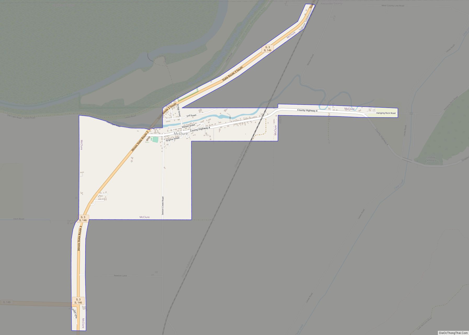
McClure is a village in McClure Precinct, Alexander County, Illinois, United States. It was incorporated in 2004 and had a population of 256 at the 2020 census. McClure is part of the Cape Girardeau–Jackson Metropolitan Statistical Area. McClure village overview: Name: McClure village LSAD Code: 47 LSAD Description: village (suffix) State: Illinois County: Alexander County … Read more

Map of McHenry city

Map of McHenry city, Illinois

McHenry is a city in McHenry County, Illinois, United States. It is a suburb, part of the Chicago metropolitan area and is located about 37 miles northwest of Chicago. Per the 2020 census, the population was 27,135. McHenry was at one time the county seat of McHenry County, which once included adjoining Lake County to … Read more

Map of McCullom Lake village

Map of McCullom Lake village

McCullom Lake is a village in McHenry County, Illinois, United States. Per the 2020 census, the population was 988. McCullom Lake village overview: Name: McCullom Lake village LSAD Code: 47 LSAD Description: village (suffix) State: Illinois County: McHenry County Incorporated: April 7, 1955 (1955-04-07) Elevation: 830 ft (250 m) Total Area: 0.36 sq mi (0.94 km²) Land Area: 0.35 sq mi (0.90 km²) Water Area: 0.02 sq mi … Read more

Map of McLeansboro city

Map of McLeansboro city

McLeansboro (/məkˈleɪnzbəroʊ/) is a city in Hamilton County, Illinois, United States. The population was 2,675 at the 2020 census. The estimated population as of 2018 was 2,773. It is the county seat of Hamilton County. McLeansboro is part of the Mount Vernon, Illinois micropolitan area. McLeansboro city overview: Name: McLeansboro city LSAD Code: 25 LSAD … Read more

Map of McLean village

Map of McLean village, Illinois

McLean is a village in McLean County, Illinois, United States. The population was 743 at the 2020 census, down from 830 in 2010. It is part of the Bloomington–Normal Metropolitan Statistical Area. McLean is the home of the Dixie Travel Plaza. McLean village overview: Name: McLean village LSAD Code: 47 LSAD Description: village (suffix) State: … Read more

Map of McNabb village

Map of McNabb village

McNabb is a village in Putnam County, Illinois, United States. The population was 285 at the 2010 census, down from 310 in 2000. It is part of the Ottawa Micropolitan Statistical Area. Just outside of McNabb is the Clear Creek Meeting House, one of the few surviving western Quaker meeting houses. The Meeting House once … Read more

Map of Mechanicsburg village

Map of Mechanicsburg village, Illinois

Mechanicsburg is a village in Sangamon County, Illinois, United States. The population was 590 at the 2010 census. It is part of the Springfield, Illinois Metropolitan Statistical Area. Mechanicsburg village overview: Name: Mechanicsburg village LSAD Code: 47 LSAD Description: village (suffix) State: Illinois County: Sangamon County Elevation: 586 ft (179 m) Total Area: 1.05 sq mi (2.72 km²) Land Area: … Read more

Map of Medora village

Map of Medora village, Illinois

Medora is a village in Macoupin County, Illinois, United States. The population was 379 at the 2020 census, down from 419 in 2010. Medora village overview: Name: Medora village LSAD Code: 47 LSAD Description: village (suffix) State: Illinois County: Jersey County, Macoupin County Elevation: 608 ft (185 m) Total Area: 0.38 sq mi (0.98 km²) Land Area: 0.38 sq mi (0.98 km²) Water … Read more

Map of Media village

Map of Media village, Illinois

Media is a village in Henderson County, Illinois, United States. The population was 107 at the 2010 census, down from 130 at the 2000 census. It is part of the Burlington, IA–IL Micropolitan Statistical Area. Media village overview: Name: Media village LSAD Code: 47 LSAD Description: village (suffix) State: Illinois County: Henderson County Founded: 1887 … Read more

Map of Melvin village, Illinois

Map of Melvin village, Illinois

Melvin is a village in Ford County, Illinois, United States. The population was 452 at the 2010 census. Melvin village overview: Name: Melvin village LSAD Code: 47 LSAD Description: village (suffix) State: Illinois County: Ford County Elevation: 810 ft (250 m) Total Area: 0.35 sq mi (0.90 km²) Land Area: 0.35 sq mi (0.90 km²) Water Area: 0.00 sq mi (0.00 km²) Total Population: 416 Population … Read more

Map of Melrose Park village

Map of Melrose Park village, Illinois

Melrose Park is a village in Cook County, Illinois, United States. It is a suburb of Chicago. As of the 2020 census it had a population of 24,796. Melrose Park had long been home to a large Italian-American population. The suburb was the home of Kiddieland Amusement Park from 1929 until 2010 (it closed in … Read more

Map of Mendota city, Illinois

Map of Mendota city, Illinois

Mendota is a city in LaSalle County, Illinois, United States, in the state’s north-central region. The population was 7,061 at the 2020 census. It is part of the Ottawa, IL Micropolitan Statistical Area. Mendota is located approximately 85 miles west of Chicago, 70 miles east of Moline and 55 miles south of Rockford. The current … Read more