Map of Ohlman village

Map of Ohlman village

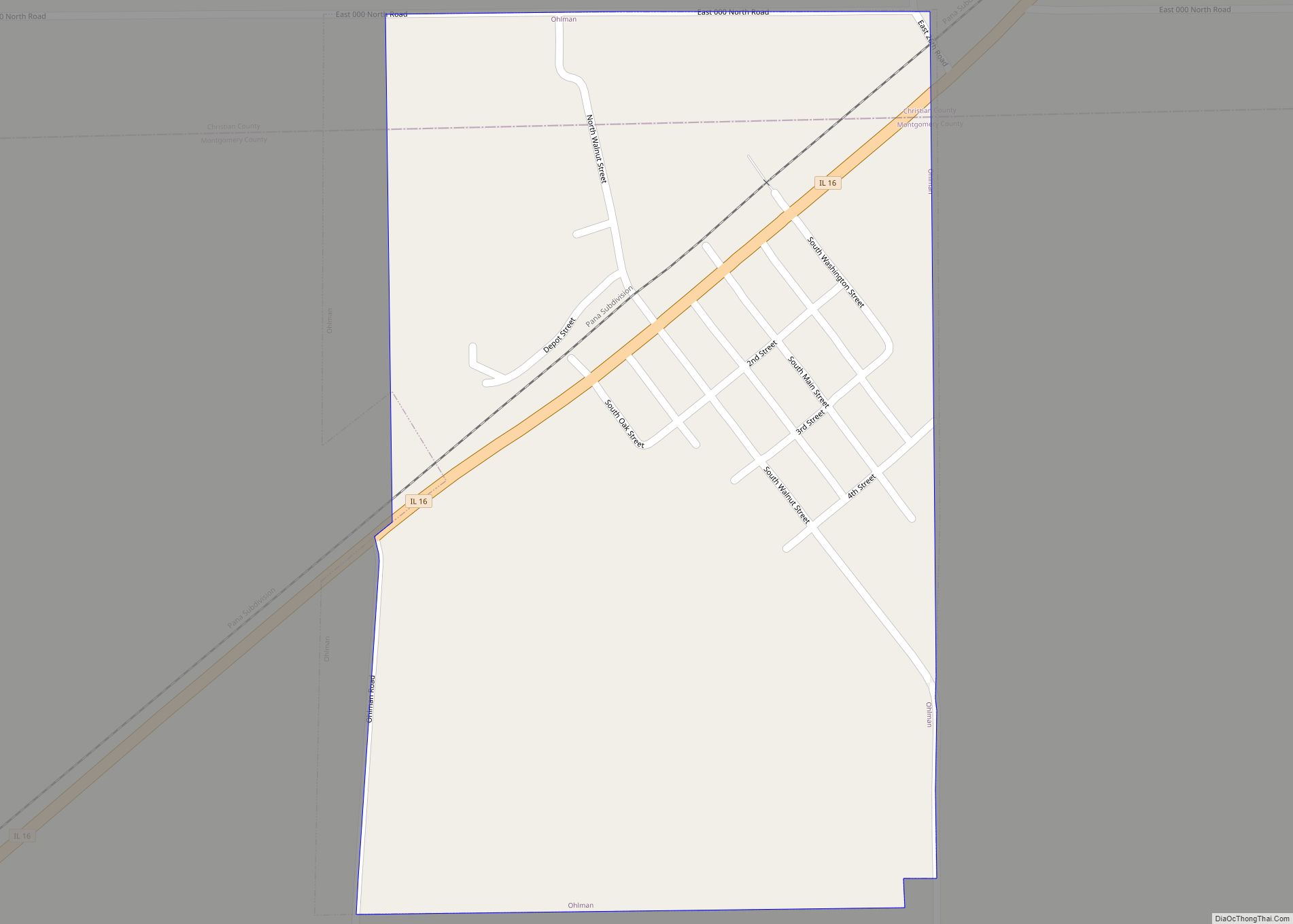
Ohlman is a village in Montgomery County, Illinois, United States. As of the 2020 census, the village had a population of 109, down from 135 in 2010. Ohlman village overview: Name: Ohlman village LSAD Code: 47 LSAD Description: village (suffix) State: Illinois County: Montgomery County Elevation: 686 ft (209 m) Total Area: 0.32 sq mi (0.83 km²) Land Area: 0.32 sq mi … Read more

Map of Old Ripley village

Map of Old Ripley village

Old Ripley is a village in Bond County, Illinois, United States. The population was 82 at the 2020 census. Old Ripley village overview: Name: Old Ripley village LSAD Code: 47 LSAD Description: village (suffix) State: Illinois County: Bond County Elevation: 558 ft (170 m) Total Area: 0.15 sq mi (0.40 km²) Land Area: 0.15 sq mi (0.40 km²) Water Area: 0.00 sq mi (0.00 km²)  0% … Read more

Map of Old Mill Creek village

Map of Old Mill Creek village

Old Mill Creek is a village in Lake County, Illinois, United States. Per the 2020 census, the population was 162. Old Mill Creek village overview: Name: Old Mill Creek village LSAD Code: 47 LSAD Description: village (suffix) State: Illinois County: Lake County Total Area: 10.85 sq mi (28.09 km²) Land Area: 10.67 sq mi (27.64 km²) Water Area: 0.17 sq mi (0.45 km²) Total … Read more

Map of Olive Branch CDP

Map of Olive Branch CDP, Illinois

Olive Branch is an unincorporated census-designated place in Alexander County, Illinois, United States. It has a post office with the ZIP code 62969. Its population was 650 at the 2020 census. Olive Branch is part of the Cape Girardeau–Jackson, MO-IL Metropolitan Statistical Area. Olive Branch CDP overview: Name: Olive Branch CDP LSAD Code: 57 LSAD … Read more

Map of Old Shawneetown village

Map of Old Shawneetown village

Old Shawneetown is a village in Gallatin County, Illinois, United States. As of the 2010 census, the village had a population of 193, down from 278 at the 2000 census. Located along the Ohio River, Shawneetown served as an important United States government administrative center for the Northwest Territory. The village was devastated by the … Read more

Map of Olmsted village

Map of Olmsted village

Olmsted is a village in Pulaski County, Illinois, along the Ohio River. The population was 299 at the 2000 census. Olmsted village overview: Name: Olmsted village LSAD Code: 47 LSAD Description: village (suffix) State: Illinois County: Pulaski County Elevation: 381 ft (116 m) Total Area: 3.50 sq mi (9.05 km²) Land Area: 3.37 sq mi (8.71 km²) Water Area: 0.13 sq mi (0.34 km²) Total Population: … Read more

Map of Olivet CDP

Map of Olivet CDP, Illinois

Olivet is a census-designated place in Elwood Township, Vermilion County, Illinois. As of the 2010 census, its population was 428. Olivet CDP overview: Name: Olivet CDP LSAD Code: 57 LSAD Description: CDP (suffix) State: Illinois County: Vermilion County Elevation: 669 ft (204 m) Total Area: 2.383 sq mi (6.17 km²) Land Area: 2.383 sq mi (6.17 km²) Water Area: 0 sq mi (0 km²) Total Population: … Read more

Map of Olympia Fields village

Map of Olympia Fields village

Olympia Fields is a village and a south suburb of Chicago in Cook County, Illinois, United States. The population was 4,718 as of the 2020 census. The municipality grew up around the prestigious Olympia Fields Country Club, originally established in 1915. Olympia Fields is noteworthy as one of the wealthiest and best educated, majority African-American … Read more

Map of Olney city

Map of Olney city, Illinois

Olney (/ˈɔːlni/ AWL-nee) is the county seat in Richland County, Illinois. The population was 9,115 at the time of the 2010 census. Olney city overview: Name: Olney city LSAD Code: 25 LSAD Description: city (suffix) State: Illinois County: Richland County Founded: 1848 Elevation: 489 ft (149 m) Total Area: 6.93 sq mi (17.95 km²) Land Area: 6.93 sq mi (17.95 km²) Water Area: … Read more

Map of Onarga village

Map of Onarga village

Onarga is a village in Onarga Township, Iroquois County, Illinois, United States. The population was 1,368 at the 2010 census, down from 1,438 at the 2000 census. Onarga village overview: Name: Onarga village LSAD Code: 47 LSAD Description: village (suffix) State: Illinois County: Iroquois County Founded: 1854 Elevation: 669 ft (204 m) Total Area: 1.67 sq mi (4.33 km²) Land … Read more

Map of Omaha village, Illinois

Map of Omaha village, Illinois

Omaha is a village in Gallatin County, Illinois, United States. The population was 266 at the 2010 census. Omaha village overview: Name: Omaha village LSAD Code: 47 LSAD Description: village (suffix) State: Illinois County: Gallatin County Elevation: 390 ft (120 m) Total Area: 0.74 sq mi (1.93 km²) Land Area: 0.74 sq mi (1.93 km²) Water Area: 0.00 sq mi (0.00 km²) Total Population: 209 Population … Read more

Map of Opdyke CDP

Map of Opdyke CDP

Opdyke is a census-designated place in the southeastern part of Jefferson County, Illinois, United States. As of the 2010 census, its population was 254. Opdyke CDP overview: Name: Opdyke CDP LSAD Code: 57 LSAD Description: CDP (suffix) State: Illinois County: Jefferson County Elevation: 515 ft (157 m) Total Area: 0.53 sq mi (1.37 km²) Land Area: 0.53 sq mi (1.37 km²) Water Area: … Read more