Map of Rochester village, Illinois

Map of Rochester village, Illinois

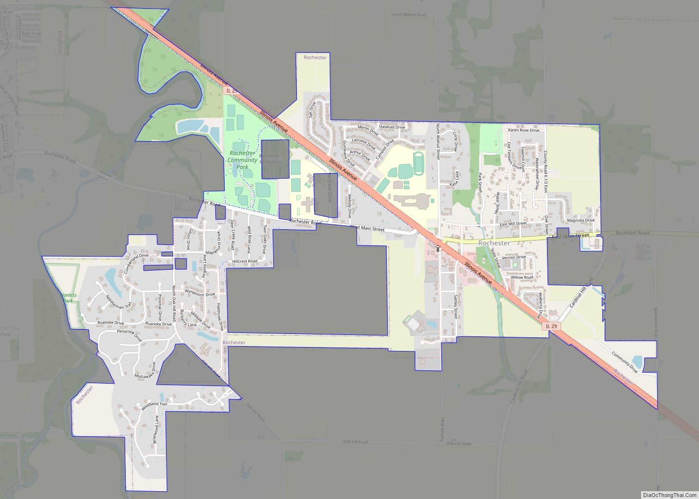
Rochester is a village and suburb of Springfield in Sangamon County, Illinois, United States. The population was 3,689 at the 2010 census, and 3,713 at a 2018 estimate. The village was settled in 1819, and is located in Rochester Township. Rochester is part of the Springfield, Illinois Metropolitan Statistical Area. Rochester village overview: Name: Rochester … Read more

Map of Rock Island Arsenal CDP

Map of Rock Island Arsenal CDP

Rock Island Arsenal is a census-designated place (CDP) in Rock Island County, Illinois, United States. The population was 149 at the 2010 census. The island contains the Rock Island National Cemetery. Rock Island Arsenal CDP overview: Name: Rock Island Arsenal CDP LSAD Code: 57 LSAD Description: CDP (suffix) State: Illinois County: Rock Island County Total … Read more

Map of Rock Falls city, Illinois

Map of Rock Falls city, Illinois

Rock Falls is a city in Whiteside County, Illinois, United States. The recorded population was 8,606 at the 2020 census, down 7.12% from 9,266 in 2010. The city is located on the Rock River, directly opposite its twin city of Sterling. Rock Falls city overview: Name: Rock Falls city LSAD Code: 25 LSAD Description: city … Read more

Map of Rockbridge village

Map of Rockbridge village, Illinois

Rockbridge is a village in Greene County, Illinois, United States. The population was 169 at the 2010 census. Rockbridge village overview: Name: Rockbridge village LSAD Code: 47 LSAD Description: village (suffix) State: Illinois County: Greene County Elevation: 541 ft (165 m) Total Area: 0.74 sq mi (1.91 km²) Land Area: 0.74 sq mi (1.91 km²) Water Area: 0.00 sq mi (0.00 km²) Total Population: 175 Population … Read more

Map of Rock Island city

Map of Rock Island city, Illinois

Rock Island is a city in and the county seat of Rock Island County, Illinois, United States. The original Rock Island, from which the city name is derived, is now called Arsenal Island. The population was 37,108 at the 2020 census. Located on the Mississippi River, it is one of the Quad Cities, along with … Read more

Map of Rockton village

Map of Rockton village

Rockton is a village in Winnebago County, Illinois. It is located in the Rock River Valley and is part of the Rockford metropolitan area. The population was 7,685 at the time of the 2010 census, up from 5,296 at the time of the 2000 census. Rockton village overview: Name: Rockton village LSAD Code: 47 LSAD … Read more

Map of Rockdale village

Map of Rockdale village, Illinois

Rockdale is a village in Will County, Illinois, United States which had a population of 1,976 during the 2010 census. Rockdale village overview: Name: Rockdale village LSAD Code: 47 LSAD Description: village (suffix) State: Illinois County: Will County Total Area: 1.41 sq mi (3.65 km²) Land Area: 1.41 sq mi (3.65 km²) Water Area: 0.00 sq mi (0.00 km²) Total Population: 2,012 Population Density: … Read more

Map of Rolling Meadows city

Map of Rolling Meadows city

Rolling Meadows is a city in Cook County, Illinois, United States. Per the 2020 census, the population was 24,200. Rolling Meadows city overview: Name: Rolling Meadows city LSAD Code: 25 LSAD Description: city (suffix) State: Illinois County: Cook County Incorporated: 1955 Total Area: 5.62 sq mi (14.56 km²) Land Area: 5.62 sq mi (14.54 km²) Water Area: 0.01 sq mi (0.02 km²)  0% Total … Read more

Map of Rockwood village

Map of Rockwood village, Illinois

Rockwood is a village in Randolph County, Illinois, United States. The population was 42 at the 2010 census. It is the headquarters of the Middle Mississippi River National Wildlife Refuge. Rockwood village overview: Name: Rockwood village LSAD Code: 47 LSAD Description: village (suffix) State: Illinois County: Randolph County Total Area: 0.21 sq mi (0.55 km²) Land Area: 0.21 sq mi … Read more

Map of Romeoville village

Map of Romeoville village

Romeoville is a village in Will County, Illinois, United States. The village is located 26 mi (42 km) southwest of Chicago on the Des Plaines River. Per the 2020 census, the population was 39,863. It is located in the southwest suburban area of Chicago near Interstate 55 and Interstate 355. Romeoville village overview: Name: Romeoville village LSAD … Read more

Map of Rome CDP, Illinois

Map of Rome CDP, Illinois

Rome is a census-designated place (CDP) in Medina Township, Peoria County, Illinois, United States. The population of the CDP was 1,738 at the 2010 census. Rome is part of the Peoria, Illinois Metropolitan Statistical Area. Rome CDP overview: Name: Rome CDP LSAD Code: 57 LSAD Description: CDP (suffix) State: Illinois County: Peoria County FIPS code: … Read more

Map of Roscoe village

Map of Roscoe village, Illinois

Roscoe is a village in Winnebago County, Illinois, along the Rock River. It is in a suburban area of the Rockford, Illinois Metropolitan Statistical Area. As of the 2010 census, the village population was 10,785, up from 6,244 at the 2000 census. The area has been undergoing a period of rapid growth. There have been … Read more