Map of Mitchellville city, Iowa

Map of Mitchellville city, Iowa

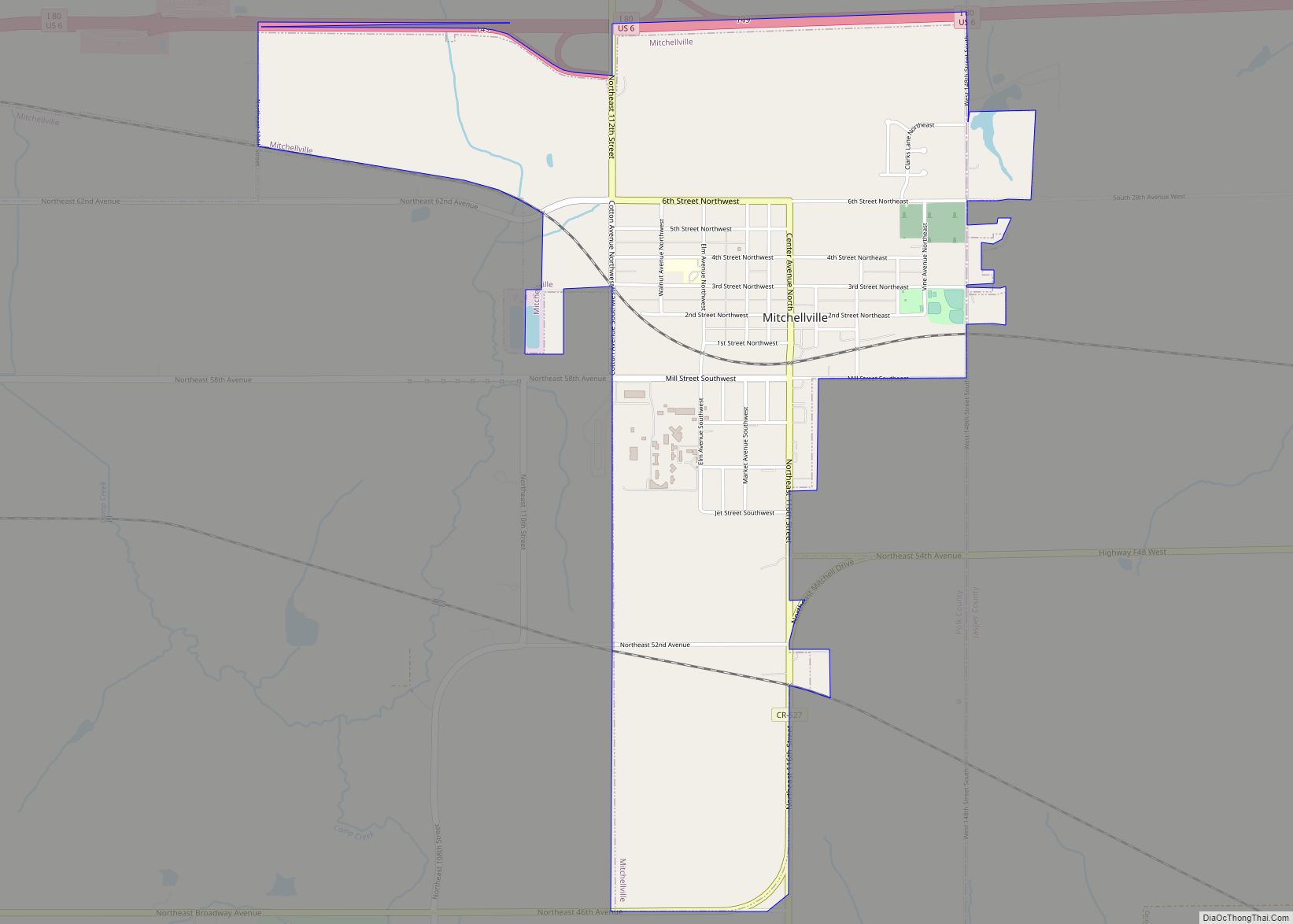
Mitchellville is a city located in Polk and Jasper counties in the U.S. state of Iowa. The population was 2,485 at the time of the 2020 census. Mitchellville is part of the Des Moines–West Des Moines Metropolitan Statistical Area. The Iowa Correctional Institution for Women is located in Mitchellville. Mitchellville city overview: Name: Mitchellville city … Read more

Map of Mitchell city, Iowa

Map of Mitchell city, Iowa

Mitchell is a city in Mitchell County, Iowa, United States. The population was 124 at the time of the 2020 census. Mitchell city overview: Name: Mitchell city LSAD Code: 25 LSAD Description: city (suffix) State: Iowa County: Mitchell County Elevation: 1,191 ft (363 m) Total Area: 0.56 sq mi (1.46 km²) Land Area: 0.56 sq mi (1.46 km²) Water Area: 0.00 sq mi (0.00 km²) Total … Read more

Map of Monmouth city, Iowa

Map of Monmouth city, Iowa

Monmouth is a city in Jackson County, Iowa, United States. The population was 129 at the time of the 2020 census. Monmouth city overview: Name: Monmouth city LSAD Code: 25 LSAD Description: city (suffix) State: Iowa County: Jackson County Incorporated: July 12, 1894 Elevation: 755 ft (230 m) Total Area: 0.57 sq mi (1.47 km²) Land Area: 0.57 sq mi (1.47 km²) Water … Read more

Map of Mondamin city

Map of Mondamin city

Mondamin is a city in Harrison County, Iowa, United States. The population was 339 at the time of the 2020 census. Mondamin city overview: Name: Mondamin city LSAD Code: 25 LSAD Description: city (suffix) State: Iowa County: Harrison County Elevation: 1,024 ft (312 m) Total Area: 0.45 sq mi (1.17 km²) Land Area: 0.45 sq mi (1.17 km²) Water Area: 0.00 sq mi (0.00 km²) Total … Read more

Map of Mona CDP

Map of Mona CDP, Iowa

Mona is an unincorporated community and census-designated place in Mitchell County, Iowa, United States. As of the 2020 census the population of Mona was 35. Mona CDP overview: Name: Mona CDP LSAD Code: 57 LSAD Description: CDP (suffix) State: Iowa County: Mitchell County Elevation: 1,165 ft (355 m) Total Area: 2.27 sq mi (5.89 km²) Land Area: 2.27 sq mi (5.89 km²) Water … Read more

Map of Montezuma city, Iowa

Map of Montezuma city, Iowa

Montezuma is a city in Poweshiek County, Iowa, United States. The population was 1,442 at the time of the 2020 census. It is the county seat of Poweshiek County. Montezuma city overview: Name: Montezuma city LSAD Code: 25 LSAD Description: city (suffix) State: Iowa County: Poweshiek County Elevation: 951 ft (290 m) Total Area: 2.48 sq mi (6.44 km²) Land … Read more

Map of Monroe city, Iowa

Map of Monroe city, Iowa

Monroe is a city in Jasper and Marion counties in Iowa, United States. The population was 1,967 at the time of the 2020 census. Monroe city overview: Name: Monroe city LSAD Code: 25 LSAD Description: city (suffix) State: Iowa County: Jasper County Elevation: 925 ft (282 m) Total Area: 1.70 sq mi (4.40 km²) Land Area: 1.70 sq mi (4.40 km²) Water Area: … Read more

Map of Monona city

Map of Monona city, Iowa

Monona is a city in Clayton County, Iowa, United States. The population was 1,471 at the time of the 2020 census. Monona city overview: Name: Monona city LSAD Code: 25 LSAD Description: city (suffix) State: Iowa County: Clayton County Elevation: 1,214 ft (370 m) Total Area: 1.36 sq mi (3.53 km²) Land Area: 1.36 sq mi (3.53 km²) Water Area: 0.00 sq mi (0.00 km²) Total … Read more

Map of Montrose city, Iowa

Map of Montrose city, Iowa

Montrose is a city in Lee County, Iowa. The population was 738 at the time of the 2020 census. The town is located on the Mississippi River. It is part of the Fort Madison–Keokuk, IA-IL-MO Micropolitan Statistical Area. Montrose city overview: Name: Montrose city LSAD Code: 25 LSAD Description: city (suffix) State: Iowa County: Lee … Read more

Map of Montour city

Map of Montour city

Montour is a city in Tama County, Iowa, United States. The population was 203 at the time of the 2020 census. Montour city overview: Name: Montour city LSAD Code: 25 LSAD Description: city (suffix) State: Iowa County: Tama County Elevation: 846 ft (258 m) Total Area: 0.46 sq mi (1.18 km²) Land Area: 0.46 sq mi (1.18 km²) Water Area: 0.00 sq mi (0.00 km²) Total … Read more

Map of Monticello city, Iowa

Map of Monticello city, Iowa

Monticello is a city in Jones County, Iowa, United States. As of the 2020 census, the city population was 4,040. Monticello city overview: Name: Monticello city LSAD Code: 25 LSAD Description: city (suffix) State: Iowa County: Jones County Elevation: 824 ft (251 m) Total Area: 5.56 sq mi (14.40 km²) Land Area: 5.53 sq mi (14.31 km²) Water Area: 0.03 sq mi (0.08 km²) Total Population: … Read more

Map of Moravia city

Map of Moravia city, Iowa

Moravia is a city in Appanoose County, Iowa, United States. The population was 637 at the time of the 2020 census. Moravia city overview: Name: Moravia city LSAD Code: 25 LSAD Description: city (suffix) State: Iowa County: Appanoose County, Monroe County Elevation: 994 ft (303 m) Total Area: 1.18 sq mi (3.05 km²) Land Area: 1.18 sq mi (3.05 km²) Water Area: 0.00 sq mi … Read more