Map of Moville city
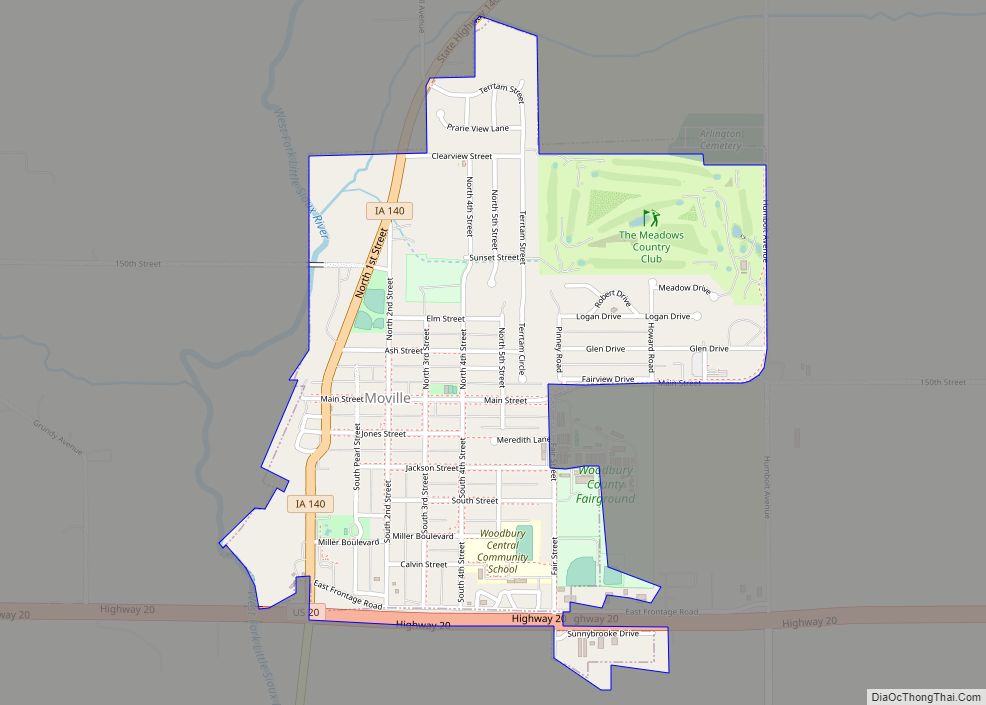
Moville is a city in Woodbury County, Iowa, United States. It is part of the Sioux City, IA–NE–SD Metropolitan Statistical Area. The population was 1,687 in the 2020 census, an increase from 1,583 in 2000. Moville city overview: Name: Moville city LSAD Code: 25 LSAD Description: city (suffix) State: Iowa County: Woodbury County Incorporated: August ... Read more
Map of Moville city
Map of Mount Vernon city, Iowa
Mount Vernon is a city in Linn County, Iowa, United States, adjacent to the city of Lisbon. The population was 4,527 at the time of the 2020 census. Mount Vernon is part of the Cedar Rapids Metropolitan Statistical Area. Mount Vernon city overview: Name: Mount Vernon city LSAD Code: 25 LSAD Description: city (suffix) State: ... Read more
Map of Mount Vernon city, Iowa
Map of Nashua city, Iowa
Nashua is a city in Chickasaw County and Floyd County, Iowa. As of the 2020 census, the city’s population was 1,551 a 6.7% decrease from 2010. The famed Little Brown Church featured in the song “The Church in the Wildwood” is located in Nashua. Nashua city overview: Name: Nashua city LSAD Code: 25 LSAD Description: ... Read more
Map of Nashua city, Iowa
Map of Mystic city, Iowa
Mystic is a city in Appanoose County, Iowa, United States. The population was 322 at the time of the 2020 census. Mystic city overview: Name: Mystic city LSAD Code: 25 LSAD Description: city (suffix) State: Iowa County: Appanoose County Elevation: 899 ft (274 m) Total Area: 2.94 sq mi (7.63 km²) Land Area: 2.94 sq mi (7.63 km²) Water Area: 0.00 sq mi (0.00 km²) Total ... Read more
Map of Mystic city, Iowa
Map of Muscatine city
Muscatine (/ˌmʌskəˈtin/ muss-kə-TEEN) is a city in Muscatine County, Iowa, United States. The population was 23,797 at the time of the 2020 census, an increase from 22,697 in 2000. The county seat of Muscatine County, it is located along the Mississippi River. The local business association states that the name Muscatine is not used by ... Read more
Map of Muscatine city
Map of Nevada city, Iowa
Nevada (/nəˈveɪdə/ nə-VAY-də) is a city in, and the county seat of, Story County, Iowa, United States. The population was 6,925 in the 2020 census, an increase from 6,658 in 2000. Nevada is part of the Ames, Iowa Metropolitan Statistical Area, which is a part of the larger Ames-Boone, Iowa Combined Statistical Area. Nevada is ... Read more
Map of Nevada city, Iowa
Map of Neola city, Iowa
Neola is a city in Pottawattamie County, Iowa, United States. The population was 918 at the time of the 2020 census. Neola city overview: Name: Neola city LSAD Code: 25 LSAD Description: city (suffix) State: Iowa County: Pottawattamie County Elevation: 1,099 ft (335 m) Total Area: 0.80 sq mi (2.08 km²) Land Area: 0.80 sq mi (2.07 km²) Water Area: 0.00 sq mi (0.01 km²) Total ... Read more
Map of Neola city, Iowa
Map of Nemaha city, Iowa
Nemaha is a city in Sac County, Iowa, United States. The population was 66 at the time of the 2020 census. Nemaha city overview: Name: Nemaha city LSAD Code: 25 LSAD Description: city (suffix) State: Iowa County: Sac County Elevation: 1,322 ft (403 m) Total Area: 0.08 sq mi (0.22 km²) Land Area: 0.08 sq mi (0.22 km²) Water Area: 0.00 sq mi (0.00 km²) Total ... Read more
Map of Nemaha city, Iowa
Map of New Albin city
New Albin is a city in Iowa Township, Allamakee County, Iowa, United States. It is the northeasternmost town in Iowa, located on the Mississippi River and the Minnesota border. The population was 432 at the time of the 2020 census. New Albin city overview: Name: New Albin city LSAD Code: 25 LSAD Description: city (suffix) ... Read more
Map of New Albin city
Map of New Hartford city, Iowa
New Hartford is a city in Butler County, Iowa, United States. The population was 570 at the time of the 2020 census. New Hartford city overview: Name: New Hartford city LSAD Code: 25 LSAD Description: city (suffix) State: Iowa County: Butler County Elevation: 899 ft (274 m) Total Area: 0.62 sq mi (1.61 km²) Land Area: 0.62 sq mi (1.61 km²) Water Area: ... Read more
Map of New Hartford city, Iowa
Map of New Hampton city, Iowa
New Hampton is a city in, and the county seat of, Chickasaw County, Iowa, United States. The population was 3,494 at the time of the 2020 census. New Hampton city overview: Name: New Hampton city LSAD Code: 25 LSAD Description: city (suffix) State: Iowa County: Chickasaw County Elevation: 1,158 ft (353 m) Total Area: 3.36 sq mi (8.69 km²) Land ... Read more
Map of New Hampton city, Iowa
Map of New London city, Iowa
New London is a city in Henry County, Iowa, United States. The population was 1,910 at the time of the 2020 census. New London city overview: Name: New London city LSAD Code: 25 LSAD Description: city (suffix) State: Iowa County: Henry County Elevation: 761 ft (232 m) Total Area: 1.04 sq mi (2.70 km²) Land Area: 1.04 sq mi (2.70 km²) Water Area: ... Read more
Map of New London city, Iowa