Map of Oakville city, Iowa
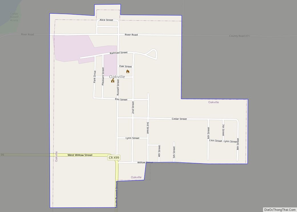
Oakville is a city in southeasern Louisa County, Iowa, United States. The population was 200 at the time of the 2020 census. It is part of the Muscatine Micropolitan Statistical Area. Oakville city overview: Name: Oakville city LSAD Code: 25 LSAD Description: city (suffix) State: Iowa County: Louisa County Elevation: 541 ft (165 m) Total Area: 0.42 sq mi ... Read more
Map of Oakville city, Iowa
Map of Oakland city, Iowa
Oakland is a city located along the West Nishnabotna River in Pottawattamie County, Iowa, United States. The population was 1,524 at the time of the 2020 census. Formerly named Big Grove, Oakland is home to Nishna Heritage Museum and a number of historical buildings. Oakland city overview: Name: Oakland city LSAD Code: 25 LSAD Description: ... Read more
Map of Oakland city, Iowa
Map of Ogden city, Iowa
Ogden is a city in Yell Township, Boone County, Iowa, United States. The population was 2,007 at the time of the 2020 census, down 1.8% from 2,044 in 2010. It is part of the Boone, Iowa Micropolitan Statistical Area, which is a part of the larger Ames-Boone, Iowa Combined Statistical Area. Ogden city overview: Name: ... Read more
Map of Ogden city, Iowa
Map of Oelwein city
Oelwein is a city in Fayette County, Iowa, United States. The population was 5,920 at the time of the 2020 census, a decrease of 11.5% from the 2000 census. The largest community in Fayette County, it is located at the junction of State Highways 3 and 150. Oelwein city overview: Name: Oelwein city LSAD Code: ... Read more
Map of Oelwein city
Map of Odebolt city
Odebolt is a city in Sac County, Iowa, United States. The population was 994 at the time of the 2020 census. Odebolt city overview: Name: Odebolt city LSAD Code: 25 LSAD Description: city (suffix) State: Iowa County: Sac County Elevation: 1,362 ft (415 m) Total Area: 1.03 sq mi (2.67 km²) Land Area: 1.03 sq mi (2.67 km²) Water Area: 0.00 sq mi (0.00 km²) Total ... Read more
Map of Odebolt city
Map of Olds city
Olds is a city in Henry County, Iowa, United States. The population was 192 at the time of the 2020 census. Olds city overview: Name: Olds city LSAD Code: 25 LSAD Description: city (suffix) State: Iowa County: Henry County Elevation: 728 ft (222 m) Total Area: 0.34 sq mi (0.88 km²) Land Area: 0.34 sq mi (0.88 km²) Water Area: 0.00 sq mi (0.00 km²) Total ... Read more
Map of Olds city
Map of Okoboji city
Okoboji is a city in Dickinson County, Iowa, United States, along the eastern shore of West Okoboji Lake in the Iowa Great Lakes region. At the time of the 2020 census, its population was 768. Okoboji city overview: Name: Okoboji city LSAD Code: 25 LSAD Description: city (suffix) State: Iowa County: Dickinson County Elevation: 1,421 ft ... Read more
Map of Okoboji city
Map of Olin city
Olin is a city in Jones County, Iowa, United States. The population was 651 at the time of the 2020 census. It is part of the Cedar Rapids Metropolitan Statistical Area. Olin city overview: Name: Olin city LSAD Code: 25 LSAD Description: city (suffix) State: Iowa County: Jones County Elevation: 761 ft (232 m) Total Area: 1.03 sq mi ... Read more
Map of Olin city
Map of Onslow city
Onslow is a city in Jones County, Iowa, United States. The population was 201 at the time of the 2020 census. It is part of the Cedar Rapids Metropolitan Statistical Area. Onslow city overview: Name: Onslow city LSAD Code: 25 LSAD Description: city (suffix) State: Iowa County: Jones County Elevation: 919 ft (280 m) Total Area: 0.19 sq mi ... Read more
Map of Onslow city
Map of Onawa city
Onawa is a city in, and the county seat of, Monona County, Iowa, United States. The population was 2,906 at the time of the 2020 Census. It is the largest town on the Iowa side of the Missouri River between Council Bluffs and Sioux City. Onawa city overview: Name: Onawa city LSAD Code: 25 LSAD ... Read more
Map of Onawa city
Map of Ollie city
Ollie is a city in Keokuk County, Iowa, United States. The population was 201 at the time of the 2020 census. Originally known as Hemingford, the town voted to change the name to Ollie in 1892. Ollie city overview: Name: Ollie city LSAD Code: 25 LSAD Description: city (suffix) State: Iowa County: Keokuk County Elevation: ... Read more
Map of Ollie city
Map of Orient city, Iowa
Orient is a city in Orient Township, Adair County, Iowa, United States. The population was 368 at the time of the 2020 census. Orient city overview: Name: Orient city LSAD Code: 25 LSAD Description: city (suffix) State: Iowa County: Adair County Elevation: 1,352 ft (412 m) Total Area: 0.43 sq mi (1.13 km²) Land Area: 0.43 sq mi (1.13 km²) Water Area: 0.00 sq mi ... Read more
Map of Orient city, Iowa