Map of Princeton city, Iowa

Map of Princeton city, Iowa

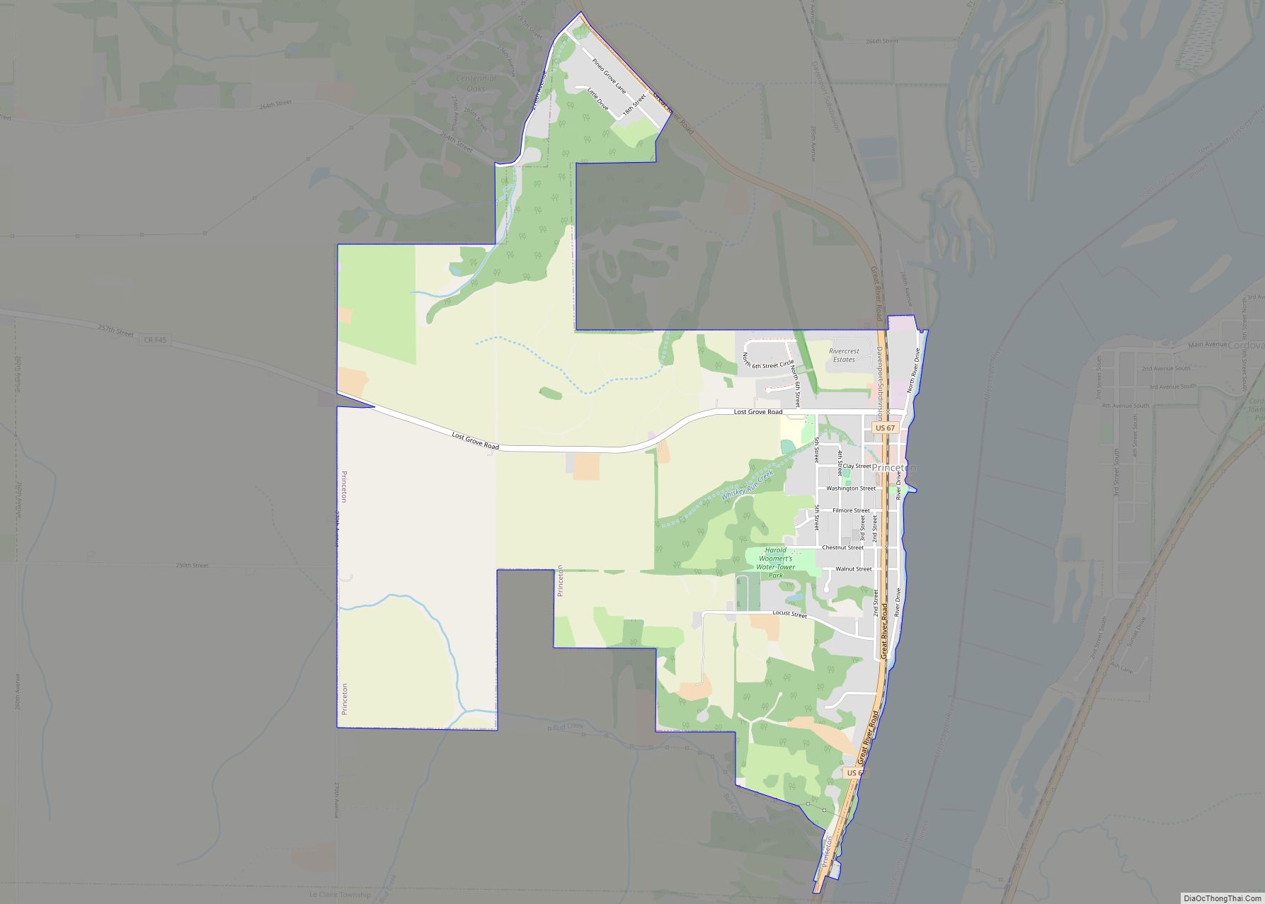
Princeton is a city in Scott County, Iowa, United States. The population was 923 at the time of the 2020 census. Princeton city overview: Name: Princeton city LSAD Code: 25 LSAD Description: city (suffix) State: Iowa County: Scott County Elevation: 584 ft (178 m) Land Area: 3.26 sq mi (8.45 km²) Water Area: 0.00 sq mi (0.00 km²) Population Density: 283.04/sq mi (109.29/km²) ZIP … Read more

Map of Primghar city

Map of Primghar city

Primghar is a city in, and the county seat of, O’Brien County, Iowa, United States. The population was 896 at the time of the 2020 census. Primghar is 23.5 miles south of Iowa State Highway 9, 28 miles east of Sioux Center and 6.75 miles north of Iowa State Highway 10. Primghar city overview: Name: … Read more

Map of Quasqueton city

Map of Quasqueton city

Quasqueton is a city in Buchanan County, Iowa, United States. The population was 570 at the time of the 2020 census. Just northwest of the town is Cedar Rock, a home designed by Frank Lloyd Wright, which is maintained by the state as a museum. Quasqueton city overview: Name: Quasqueton city LSAD Code: 25 LSAD … Read more

Map of Pulaski city, Iowa

Map of Pulaski city, Iowa

Pulaski is a city in Davis County, Iowa, United States. The population was 264 at the time of the 2020 census. Pulaski city overview: Name: Pulaski city LSAD Code: 25 LSAD Description: city (suffix) State: Iowa County: Davis County Elevation: 833 ft (254 m) Total Area: 0.44 sq mi (1.14 km²) Land Area: 0.44 sq mi (1.14 km²) Water Area: 0.00 sq mi (0.00 km²) Total … Read more

Map of Protivin city

Map of Protivin city

Protivin is a city in Chickasaw and Howard counties in the U.S. state of Iowa. The population was 269 at the time of the 2020 census. Early settlers named the city after the Bohemian town of Protivín in what is now the south of the Czech Republic. The current mayor of Protivin is Michael Lensing. … Read more

Map of Rake city

Map of Rake city

Rake is a town in Winnebago County, Iowa, United States. The population was 186 at the time of the 2020 census. Its ZIP code is 50465. Rake city overview: Name: Rake city LSAD Code: 25 LSAD Description: city (suffix) State: Iowa County: Winnebago County Elevation: 1,158 ft (353 m) Total Area: 0.76 sq mi (1.96 km²) Land Area: 0.76 sq mi (1.96 km²) … Read more

Map of Radcliffe city

Map of Radcliffe city

Radcliffe is a city in Hardin County, Iowa, United States. The population was 555 at the time of the 2020 census. Radcliffe city overview: Name: Radcliffe city LSAD Code: 25 LSAD Description: city (suffix) State: Iowa County: Hardin County Elevation: 1,184 ft (361 m) Total Area: 1.00 sq mi (2.58 km²) Land Area: 1.00 sq mi (2.58 km²) Water Area: 0.00 sq mi (0.00 km²) Total … Read more

Map of Quimby city

Map of Quimby city

Quimby is a city in Cherokee County, Iowa, United States. The population was 249 at the time of the 2020 census. Quimby city overview: Name: Quimby city LSAD Code: 25 LSAD Description: city (suffix) State: Iowa County: Cherokee County Elevation: 1,184 ft (361 m) Total Area: 0.41 sq mi (1.06 km²) Land Area: 0.41 sq mi (1.06 km²) Water Area: 0.00 sq mi (0.00 km²) Total … Read more

Map of Randall city

Map of Randall city, Iowa

Randall is a city in Hamilton County, Iowa, United States. The population was 154 at the time of the 2020 census. Randall city overview: Name: Randall city LSAD Code: 25 LSAD Description: city (suffix) State: Iowa County: Hamilton County Elevation: 1,020 ft (311 m) Total Area: 0.41 sq mi (1.05 km²) Land Area: 0.41 sq mi (1.05 km²) Water Area: 0.00 sq mi (0.00 km²) Total … Read more

Map of Randalia city

Map of Randalia city

Randalia is a city in Fayette County, Iowa, United States. The population was 51 at the time of the 2020 census. Randalia city overview: Name: Randalia city LSAD Code: 25 LSAD Description: city (suffix) State: Iowa County: Fayette County Elevation: 1,115 ft (340 m) Total Area: 0.19 sq mi (0.48 km²) Land Area: 0.19 sq mi (0.48 km²) Water Area: 0.00 sq mi (0.00 km²) Total … Read more

Map of Ralston city

Map of Ralston city, Iowa

Ralston is a city in Carroll and Greene counties in the U.S. state of Iowa. The population was 81 at the time of the 2020 census. Ralston city overview: Name: Ralston city LSAD Code: 25 LSAD Description: city (suffix) State: Iowa County: Carroll County, Greene County Elevation: 1,129 ft (344 m) Total Area: 1.97 sq mi (5.11 km²) Land Area: … Read more

Map of Raymond city

Map of Raymond city, Iowa

Raymond is a city in Black Hawk County, Iowa, United States. The population was 759 at the time of the 2020 census. It is part of the Waterloo–Cedar Falls Metropolitan Statistical Area. Raymond city overview: Name: Raymond city LSAD Code: 25 LSAD Description: city (suffix) State: Iowa County: Black Hawk County Elevation: 909 ft (277 m) Total … Read more