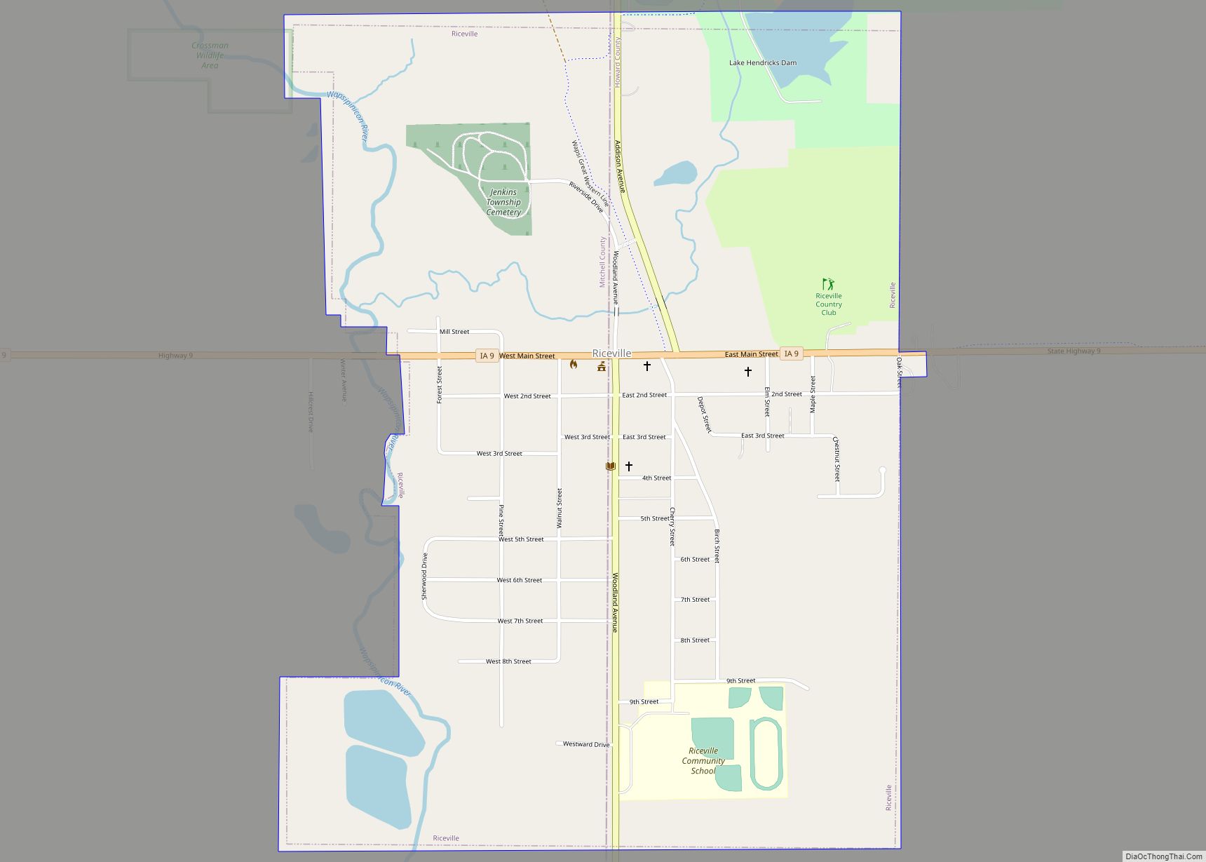
Map of Rhodes city

Map of Rhodes city

Rhodes is a city in Marshall County, Iowa, United States. The population was 271 at the time of the 2020 census. Rhodes city overview: Name: Rhodes city LSAD Code: 25 LSAD Description: city (suffix) State: Iowa County: Marshall County Elevation: 1,020 ft (311 m) Total Area: 1.01 sq mi (2.63 km²) Land Area: 1.01 sq mi (2.63 km²) Water Area: 0.00 sq mi (0.00 km²) Total … Read more

Map of Richland city, Iowa

Map of Richland city, Iowa

Richland is a city in Keokuk County, Iowa, United States. The population was 542 at the time of the 2020 census. Richland city overview: Name: Richland city LSAD Code: 25 LSAD Description: city (suffix) State: Iowa County: Keokuk County Elevation: 771 ft (235 m) Total Area: 1.03 sq mi (2.68 km²) Land Area: 1.03 sq mi (2.68 km²) Water Area: 0.00 sq mi (0.00 km²) Total … Read more

Map of Ridgeway city, Iowa

Map of Ridgeway city, Iowa

Ridgeway is a city in Winneshiek County, Iowa, United States. The population was 275 at the time of the 2020 census. Ridgeway city overview: Name: Ridgeway city LSAD Code: 25 LSAD Description: city (suffix) State: Iowa County: Winneshiek County Elevation: 1,198 ft (365 m) Total Area: 0.76 sq mi (1.96 km²) Land Area: 0.76 sq mi (1.96 km²) Water Area: 0.00 sq mi (0.00 km²) Total … Read more

Map of Ricketts city

Map of Ricketts city

Ricketts is a city in Crawford County, Iowa, United States, along the Middle Soldier River. The population was 109 at the time of the 2020 census. Ricketts city overview: Name: Ricketts city LSAD Code: 25 LSAD Description: city (suffix) State: Iowa County: Crawford County Elevation: 1,306 ft (398 m) Total Area: 0.25 sq mi (0.64 km²) Land Area: 0.25 sq mi (0.64 km²) … Read more

Map of Rickardsville city

Map of Rickardsville city

Rickardsville is a city in Dubuque County, Iowa, United States. The population was 202 at the time of the 2020 census, up from 191 in 2000. Rickardsville city overview: Name: Rickardsville city LSAD Code: 25 LSAD Description: city (suffix) State: Iowa County: Dubuque County Elevation: 1,033 ft (315 m) Total Area: 0.92 sq mi (2.38 km²) Land Area: 0.92 sq mi (2.38 km²) … Read more

Map of Rippey city

Map of Rippey city

Rippey is a city in Greene County, Iowa, United States. The population was 220 at the time of the 2020 census. Rippey city overview: Name: Rippey city LSAD Code: 25 LSAD Description: city (suffix) State: Iowa County: Greene County Elevation: 1,073 ft (327 m) Total Area: 0.87 sq mi (2.24 km²) Land Area: 0.87 sq mi (2.24 km²) Water Area: 0.00 sq mi (0.00 km²) Total … Read more

Map of Ringsted city

Map of Ringsted city

Ringsted is a city in Emmet County, Iowa, United States. At the 2020 census, the population was 365. Ringsted city overview: Name: Ringsted city LSAD Code: 25 LSAD Description: city (suffix) State: Iowa County: Emmet County Elevation: 1,283 ft (391 m) Total Area: 1.00 sq mi (2.58 km²) Land Area: 1.00 sq mi (2.58 km²) Water Area: 0.00 sq mi (0.00 km²) Total Population: 365 Population … Read more

Map of Rinard city

Map of Rinard city

Rinard is a city in Calhoun County, Iowa, United States. The population was 38 at the time of the 2020 census. Rinard city overview: Name: Rinard city LSAD Code: 25 LSAD Description: city (suffix) State: Iowa County: Calhoun County Elevation: 1,168 ft (356 m) Total Area: 1.00 sq mi (2.59 km²) Land Area: 1.00 sq mi (2.59 km²) Water Area: 0.00 sq mi (0.00 km²) Total … Read more

Map of Riverside city, Iowa

Map of Riverside city, Iowa

Riverside is a city in rural Washington County, Iowa, United States, along the English River on Iowa Highway 22. It is part of the Iowa City, Iowa Metropolitan Statistical Area. The population was 1,060 at the time of the 2020 census. It is part of the Highland Community School District. Riverside proclaimed itself the future … Read more

Map of Riverdale city, Iowa

Map of Riverdale city, Iowa

Riverdale is a city in Scott County, Iowa, United States. The population was 379 at the time of the 2020 census. Arconic has an aluminum rolling mill in Riverdale that employs approximately 2,000 people. The city is surrounded on three sides by the city of Bettendorf, and on the fourth by the Mississippi River. Riverdale … Read more

Map of River Sioux CDP

Map of River Sioux CDP

River Sioux is an unincorporated community and census-designated place in Harrison County, Iowa, United States. As of the 2010 Census the population was 59. River Sioux CDP overview: Name: River Sioux CDP LSAD Code: 57 LSAD Description: CDP (suffix) State: Iowa County: Harrison County Elevation: 1,038 ft (316 m) Total Area: 0.38 sq mi (0.99 km²) Land Area: 0.38 sq mi (0.99 km²) … Read more

Map of Rochester city

Map of Rochester CDP, Iowa

Rochester is an unincorporated community and census-designated place (CDP) in Rochester Township, Cedar County, Iowa, United States. As of the 2010 census it had a population of 133. Rochester CDP overview: Name: Rochester CDP LSAD Code: 57 LSAD Description: CDP (suffix) State: Iowa County: Cedar County Elevation: 665 ft (203 m) Total Area: 0.98 sq mi (2.53 km²) Land Area: … Read more