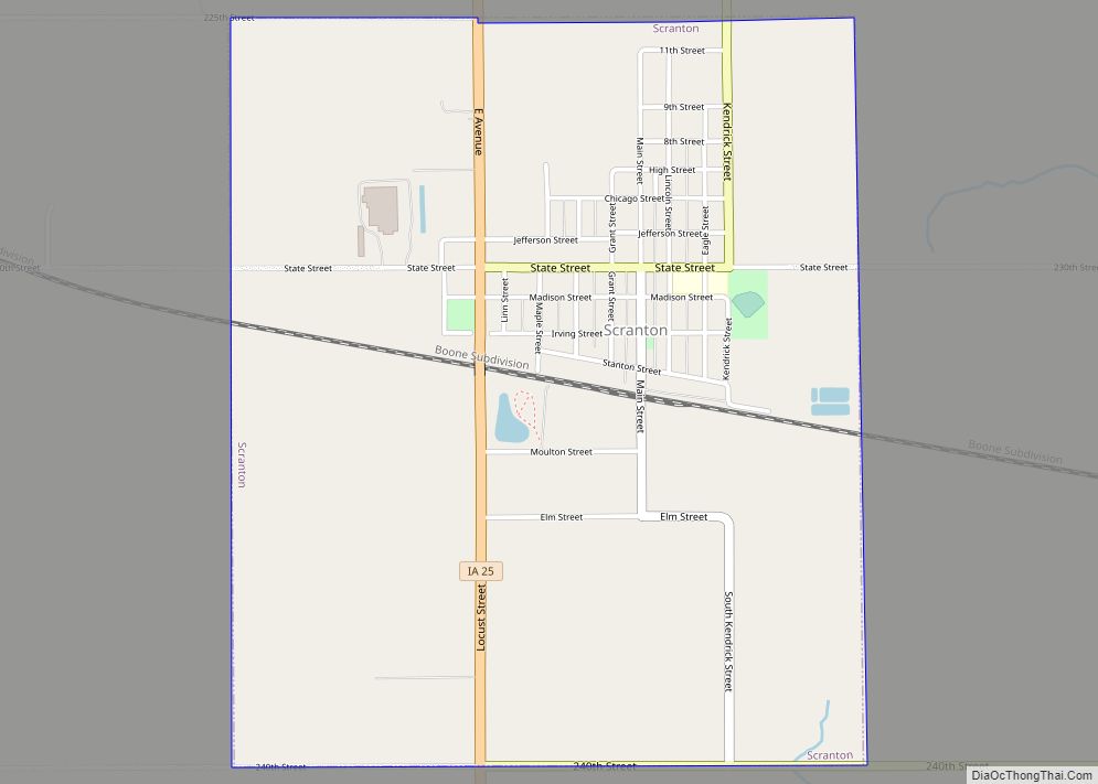
Map of Schleswig city

Map of Schleswig city

Schleswig is a city in Crawford County, Iowa, United States. The population was 830 at the time of the 2020 census. Schleswig city overview: Name: Schleswig city LSAD Code: 25 LSAD Description: city (suffix) State: Iowa County: Crawford County Elevation: 1,503 ft (458 m) Total Area: 1.25 sq mi (3.24 km²) Land Area: 1.24 sq mi (3.21 km²) Water Area: 0.01 sq mi (0.03 km²) Total … Read more

Map of Searsboro city

Map of Searsboro city

Searsboro in an unincorporated community in Poweshiek County, Iowa, United States. The population was 148 at the 2010 census. The city attempted to disincorporate in 2011, but the move failed when Poweshiek County refused to take control of the city’s infrastructure. Searsboro city overview: Name: Searsboro city LSAD Code: 25 LSAD Description: city (suffix) State: … Read more

Map of Seymour city

Map of Seymour city, Iowa

Seymour is a city in Wayne County, Iowa, United States. The population was 634 at the time of the 2020 census. Seymour city overview: Name: Seymour city LSAD Code: 25 LSAD Description: city (suffix) State: Iowa County: Wayne County Elevation: 1,073 ft (327 m) Total Area: 2.39 sq mi (6.20 km²) Land Area: 2.39 sq mi (6.20 km²) Water Area: 0.00 sq mi (0.00 km²) Total … Read more

Map of Sexton CDP

Map of Sexton CDP

Sexton is an unincorporated community and census-designated place in Irvington Township, Kossuth County, Iowa, United States. It is located at the intersection of U.S. Route 18 and Kossuth CR P60. As of the 2010 census it had a population of 37. Sexton CDP overview: Name: Sexton CDP LSAD Code: 57 LSAD Description: CDP (suffix) State: … Read more

Map of Sergeant Bluff city

Map of Sergeant Bluff city

Sergeant Bluff is a city in Woodbury County, Iowa, United States. It is part of the Sioux City, IA–NE–SD Metropolitan Statistical Area. The population was 5,015 at the time of the 2020 census. Sergeant Bluff city overview: Name: Sergeant Bluff city LSAD Code: 25 LSAD Description: city (suffix) State: Iowa County: Woodbury County Elevation: 1,093 ft … Read more

Map of Sharpsburg city, Iowa

Map of Sharpsburg city, Iowa

Sharpsburg is a city in Taylor County, Iowa, United States. The population was 72 at the time of the 2020 census. Sharpsburg was founded in 1884 as a stop on the Chicago, Burlington and Quincy Railroad. A post office was established in 1886, and the city was incorporated in 1905. Sharpsburg city overview: Name: Sharpsburg … Read more

Map of Shannon City city

Map of Shannon City

Shannon City is a city in southern Union and northern Ringgold counties in the U.S. state of Iowa. The population was 73 at the time of the 2020 census. Shannon City overview: Name: Shannon City LSAD Code: 25 LSAD Description: city (suffix) State: Iowa County: Ringgold County, Union County Elevation: 1,224 ft (373 m) Total Area: 0.41 sq mi … Read more

Map of Shambaugh city

Map of Shambaugh city

Shambaugh is a city in Page County, Iowa, United States. The population was 159 at the time of the 2020 census. Shambaugh city overview: Name: Shambaugh city LSAD Code: 25 LSAD Description: city (suffix) State: Iowa County: Page County Elevation: 984 ft (300 m) Total Area: 0.36 sq mi (0.94 km²) Land Area: 0.36 sq mi (0.94 km²) Water Area: 0.00 sq mi (0.00 km²) Total … Read more

Map of Sheldahl city

Map of Sheldahl city

Sheldahl is a city in Polk, Boone, and Story counties in the U.S. state of Iowa. The population was 297 at the time of the 2020 census. The Boone County portion of Sheldahl is part of the Boone Micropolitan Statistical Area, while the Story County portion is part of the Ames Metropolitan Statistical Area. Together, … Read more

Map of Shelby city, Iowa

Map of Shelby city, Iowa

Shelby is a city in Pottawattamie and Shelby counties in the U.S. state of Iowa. The population was 727 at the time of the 2020 census. Shelby city overview: Name: Shelby city LSAD Code: 25 LSAD Description: city (suffix) State: Iowa County: Pottawattamie County, Shelby County Elevation: 1,312 ft (400 m) Total Area: 1.87 sq mi (4.85 km²) Land Area: … Read more

Map of Sheffield city, Iowa

Map of Sheffield city, Iowa

Sheffield is a city in Franklin County, Iowa, United States. The population was 1,130 at the time of the 2020 census. Sheffield city overview: Name: Sheffield city LSAD Code: 25 LSAD Description: city (suffix) State: Iowa County: Franklin County Elevation: 1,076 ft (328 m) Total Area: 5.60 sq mi (14.50 km²) Land Area: 5.57 sq mi (14.42 km²) Water Area: 0.03 sq mi (0.07 km²) Total … Read more

Map of Shellsburg city

Map of Shellsburg city

Shellsburg is a city in Benton County, Iowa, United States. The population was 961 at the time of the 2020 census. It is part of the Cedar Rapids Metropolitan Statistical Area. Shellsburg city overview: Name: Shellsburg city LSAD Code: 25 LSAD Description: city (suffix) State: Iowa County: Benton County Elevation: 791 ft (241 m) Total Area: 0.79 sq mi … Read more