Map of Grantville CDP, Kansas
Grantville is an unincorporated community in Jefferson County, Kansas, United States. As of the 2020 census, the population of the community and nearby areas was 182. It is located east of Topeka on the south side of US-24 highway between Barton Rd and KOA/Wilson Rd. Grantville CDP overview: Name: Grantville CDP LSAD Code: 57 LSAD ... Read more
Map of Grantville CDP, Kansas
Map of Great Bend city, Kansas
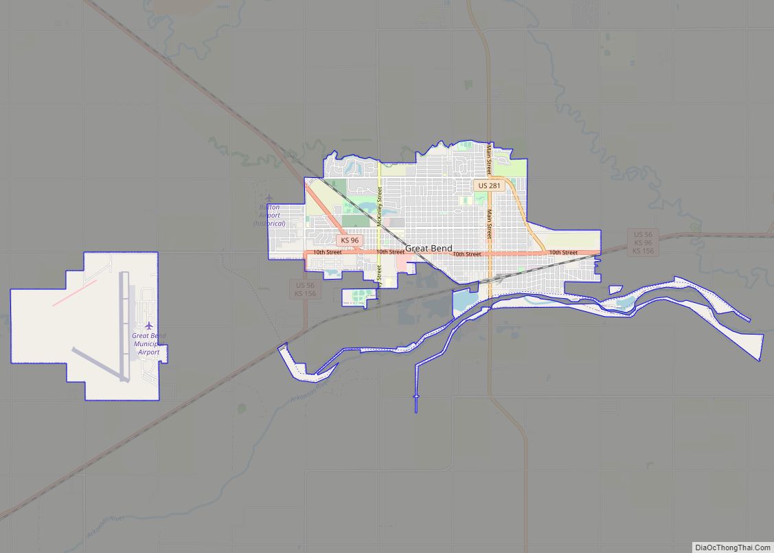
Great Bend is a city in and the county seat of Barton County, Kansas, United States. It is named for its location at the point where the course of the Arkansas River bends east then southeast. As of the 2020 census, the population of the city was 14,733. It is home to Barton Community College. ... Read more
Map of Great Bend city, Kansas
Map of Green city, Kansas
Green is a city in Clay County, Kansas, United States. As of the 2020 census, the population of the city was 95. Green city overview: Name: Green city LSAD Code: 25 LSAD Description: city (suffix) State: Kansas County: Clay County Incorporated: 1908 Elevation: 1,381 ft (421 m) Total Area: 0.20 sq mi (0.51 km²) Land Area: 0.20 sq mi (0.51 km²) Water Area: ... Read more
Map of Green city, Kansas
Map of Greeley city, Kansas
Greeley is a city in Anderson County, Kansas, United States. As of the 2020 census, the population of the city was 273. Greeley city overview: Name: Greeley city LSAD Code: 25 LSAD Description: city (suffix) State: Kansas County: Anderson County Founded: 1854 Incorporated: 1881 Elevation: 896 ft (273 m) Total Area: 0.35 sq mi (0.91 km²) Land Area: 0.34 sq mi (0.89 km²) ... Read more
Map of Greeley city, Kansas
Map of Grenola city
Grenola is a city in Elk County, Kansas, United States. As of the 2020 census, the population of the city was 151. Grenola city overview: Name: Grenola city LSAD Code: 25 LSAD Description: city (suffix) State: Kansas County: Elk County Founded: 1879 Incorporated: 1880 Elevation: 1,119 ft (341 m) Total Area: 0.47 sq mi (1.21 km²) Land Area: 0.47 sq mi (1.20 km²) ... Read more
Map of Grenola city
Map of Greensburg city, Kansas
Greensburg is a city in, and the county seat of, Kiowa County, Kansas, United States. As of the 2020 United States census, the population of the city was 740. It is home to the world’s largest hand-dug well. On the evening of May 4, 2007, Greensburg was devastated by an EF5 tornado that leveled at ... Read more
Map of Greensburg city, Kansas
Map of Greenleaf city, Kansas
Greenleaf is a city in Washington County, Kansas, United States. As of the 2020 census, the population of the city was 350. Greenleaf city overview: Name: Greenleaf city LSAD Code: 25 LSAD Description: city (suffix) State: Kansas County: Washington County Founded: 1876 Incorporated: 1880 Elevation: 1,417 ft (432 m) Total Area: 0.45 sq mi (1.18 km²) Land Area: 0.45 sq mi (1.17 km²) ... Read more
Map of Greenleaf city, Kansas
Map of Gypsum city, Kansas
Gypsum is a city in Saline County, Kansas, United States. As of the 2020 census, the population of the city was 400. Gypsum city overview: Name: Gypsum city LSAD Code: 25 LSAD Description: city (suffix) State: Kansas County: Saline County Founded: 1800s Incorporated: 1887 Elevation: 1,227 ft (374 m) Total Area: 0.37 sq mi (0.97 km²) Land Area: 0.37 sq mi (0.97 km²) ... Read more
Map of Gypsum city, Kansas
Map of Grinnell city, Kansas
Grinnell is a city in Gove County, Kansas, United States. As of the 2020 census, the population of the city was 260. Grinnell city overview: Name: Grinnell city LSAD Code: 25 LSAD Description: city (suffix) State: Kansas County: Gove County Founded: 1880s Incorporated: 1917 Elevation: 2,914 ft (888 m) Total Area: 0.49 sq mi (1.27 km²) Land Area: 0.49 sq mi (1.27 km²) ... Read more
Map of Grinnell city, Kansas
Map of Gridley city, Kansas
Gridley is a city in Coffey County, Kansas, United States. As of the 2020 census, the population of the city was 313. Gridley city overview: Name: Gridley city LSAD Code: 25 LSAD Description: city (suffix) State: Kansas County: Coffey County Elevation: 1,142 ft (348 m) Total Area: 0.49 sq mi (1.27 km²) Land Area: 0.43 sq mi (1.11 km²) Water Area: 0.06 sq mi (0.16 km²) ... Read more
Map of Gridley city, Kansas
Map of Hamilton city, Kansas
Hamilton is a city in Greenwood County, Kansas, United States. As of the 2020 census, the population of the city was 182. Hamilton city overview: Name: Hamilton city LSAD Code: 25 LSAD Description: city (suffix) State: Kansas County: Greenwood County Founded: 1879 Incorporated: 1903 Elevation: 1,099 ft (335 m) Total Area: 0.31 sq mi (0.81 km²) Land Area: 0.31 sq mi (0.81 km²) ... Read more
Map of Hamilton city, Kansas
Map of Halstead city
Halstead is a city in Harvey County, Kansas, United States. Halstead was named in honor of Murat Halstead, a respected Civil War correspondent and newspaper editor. As of the 2020 census, the population of the city was 2,179. Halstead city overview: Name: Halstead city LSAD Code: 25 LSAD Description: city (suffix) State: Kansas County: Harvey ... Read more
Map of Halstead city