Map of Ingalls city, Kansas

Map of Ingalls city, Kansas

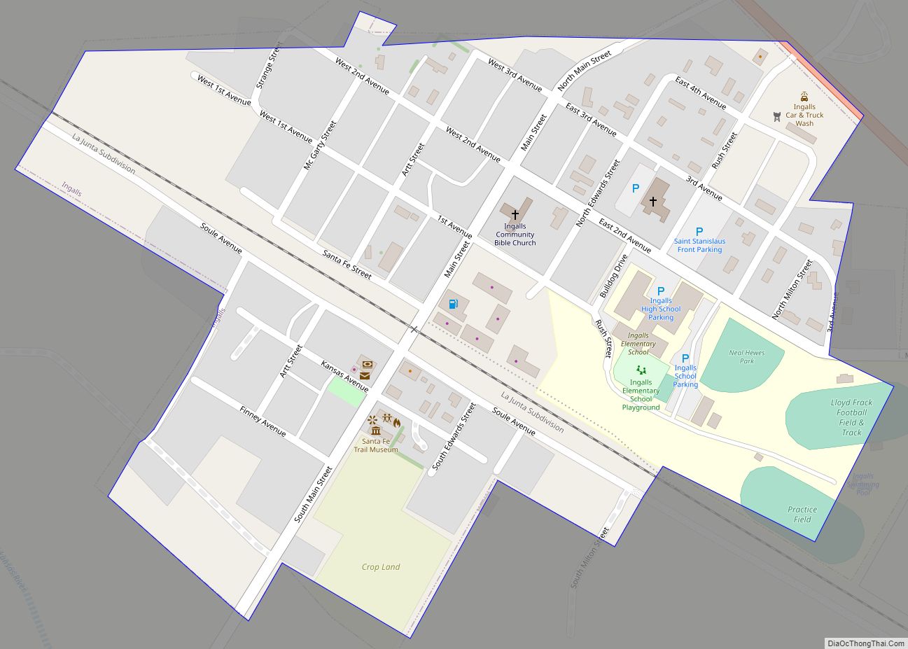
Ingalls is a city in Gray County, Kansas, United States. As of the 2020 census, the population of the city was 252. Ingalls city overview: Name: Ingalls city LSAD Code: 25 LSAD Description: city (suffix) State: Kansas County: Gray County Founded: 1880s Incorporated: 1929 Elevation: 2,671 ft (814 m) Total Area: 0.25 sq mi (0.66 km²) Land Area: 0.25 sq mi (0.66 km²) … Read more

Map of Jamestown city, Kansas

Map of Jamestown city, Kansas

Jamestown is a city in Cloud County, Kansas, United States. As of the 2020 census, the population of the city was 237. Jamestown city overview: Name: Jamestown city LSAD Code: 25 LSAD Description: city (suffix) State: Kansas County: Cloud County Founded: 1878 Incorporated: 1883 Elevation: 1,437 ft (438 m) Total Area: 0.29 sq mi (0.76 km²) Land Area: 0.29 sq mi (0.76 km²) … Read more

Map of Iuka city, Kansas

Map of Iuka city, Kansas

Iuka is a city in Pratt County, Kansas, United States. As of the 2020 census, the population of the city was 151. Iuka city overview: Name: Iuka city LSAD Code: 25 LSAD Description: city (suffix) State: Kansas County: Pratt County Founded: 1877 Incorporated: 1908 Elevation: 1,959 ft (597 m) Total Area: 0.66 sq mi (1.70 km²) Land Area: 0.66 sq mi (1.70 km²) … Read more

Map of Isabel city

Map of Isabel city, Kansas

Isabel is a city in Barber County, Kansas, United States. As of the 2020 census, the population of the city was 68. Isabel city overview: Name: Isabel city LSAD Code: 25 LSAD Description: city (suffix) State: Kansas County: Barber County Founded: 1887 Incorporated: 1909 Elevation: 1,847 ft (563 m) Total Area: 0.25 sq mi (0.65 km²) Land Area: 0.25 sq mi (0.65 km²) … Read more

Map of Jewell city

Map of Jewell city

Jewell is a city in Jewell County, Kansas, United States. As of the 2020 census, the population of the city was 370. Jewell city overview: Name: Jewell city LSAD Code: 25 LSAD Description: city (suffix) State: Kansas County: Jewell County Founded: 1870 Incorporated: 1880 Elevation: 1,555 ft (474 m) Total Area: 0.41 sq mi (1.06 km²) Land Area: 0.41 sq mi (1.06 km²) … Read more

Map of Jetmore city

Map of Jetmore city

Jetmore is a city in and the county seat of Hodgeman County, Kansas, United States. As of the 2020 census, the population of the city was 770. Jetmore city overview: Name: Jetmore city LSAD Code: 25 LSAD Description: city (suffix) State: Kansas County: Hodgeman County Founded: 1870s Incorporated: 1887 Elevation: 2,307 ft (703 m) Total Area: 4.21 sq mi … Read more

Map of Jennings city, Kansas

Map of Jennings city, Kansas

Jennings is a city in Decatur County, Kansas, United States. As of the 2020 census, the population of the city was 81. Jennings city overview: Name: Jennings city LSAD Code: 25 LSAD Description: city (suffix) State: Kansas County: Decatur County Founded: 1870s Incorporated: 1906 Elevation: 2,510 ft (770 m) Total Area: 0.27 sq mi (0.69 km²) Land Area: 0.27 sq mi (0.69 km²) … Read more

Map of Kanopolis city

Map of Kanopolis city

Kanopolis is a city in Ellsworth County, Kansas, United States. As of the 2020 census, the population of the city was 443. It was built on the site of Fort Harker, a United States Army post that housed infantry and cavalry troops involved in the Indian Wars from 1867 to 1872. Kanopolis city overview: Name: … Read more

Map of Junction City, Kansas

Map of Junction City, Kansas

Junction City is a city in and the county seat of Geary County, Kansas, United States. As of the 2020 census, the population of the city was 22,932. Fort Riley, a major U.S. Army post, is nearby. Junction City overview: Name: Junction City LSAD Code: 25 LSAD Description: city (suffix) State: Kansas County: Geary County … Read more

Map of Johnson City city

Map of Johnson City, Kansas

Johnson City is a city in and the county seat of Stanton County, Kansas, United States. As of the 2020 census, the population of the city was 1,464. Johnson City overview: Name: Johnson City LSAD Code: 25 LSAD Description: city (suffix) State: Kansas County: Stanton County Founded: 1885 Incorporated: 1888 Elevation: 3,340 ft (1,020 m) Total Area: … Read more

Map of Kensington city, Kansas

Map of Kensington city, Kansas

Kensington is a city in Smith County, Kansas, United States. As of the 2020 census, the population of the city was 399. Kensington city overview: Name: Kensington city LSAD Code: 25 LSAD Description: city (suffix) State: Kansas County: Smith County Founded: 1887 Incorporated: 1900 Elevation: 1,778 ft (542 m) Total Area: 0.34 sq mi (0.87 km²) Land Area: 0.34 sq mi (0.87 km²) … Read more

Map of Kechi city

Map of Kechi city

Kechi /ˈkiːtʃaɪ/ is a city in Sedgwick County, Kansas, United States, and a suburb of Wichita. As of the 2020 census, the population of the city was 2,217. Kechi city overview: Name: Kechi city LSAD Code: 25 LSAD Description: city (suffix) State: Kansas County: Sedgwick County Founded: 1880s Incorporated: 1957 Elevation: 1,381 ft (421 m) Total Area: … Read more