Map of Nortonville city

Map of Nortonville city, Kansas

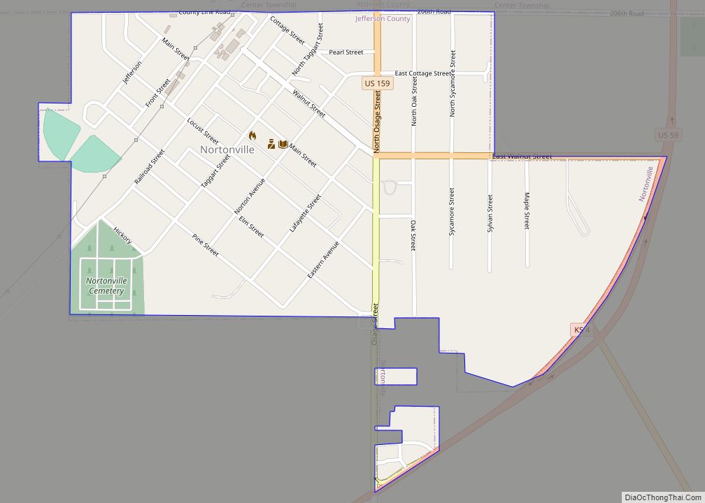
Nortonville is a city in Jefferson County, Kansas, United States. As of the 2020 census, the population of the city was 601. Nortonville city overview: Name: Nortonville city LSAD Code: 25 LSAD Description: city (suffix) State: Kansas County: Jefferson County Incorporated: 1884 Elevation: 1,161 ft (354 m) Total Area: 0.44 sq mi (1.15 km²) Land Area: 0.43 sq mi (1.12 km²) Water Area: … Read more

Map of Oberlin city

Map of Oberlin city, Kansas

Oberlin is a city in and the county seat of Decatur County, Kansas, United States. As of the 2020 census, its population was 1,644. Oberlin city overview: Name: Oberlin city LSAD Code: 25 LSAD Description: city (suffix) State: Kansas County: Decatur County Founded: 1872 Incorporated: 1885 Elevation: 2,562 ft (781 m) Total Area: 1.91 sq mi (4.95 km²) Land Area: … Read more

Map of Oakley city, Kansas

Map of Oakley city, Kansas

Oakley is a city in Gove, Logan, and Thomas counties in the U.S. state of Kansas. It is the county seat of Logan County. As of the 2020 census, the population of the city was 2,046. Oakley city overview: Name: Oakley city LSAD Code: 25 LSAD Description: city (suffix) State: Kansas County: Gove County, Logan … Read more

Map of Oaklawn-Sunview CDP

Map of Oaklawn-Sunview CDP

Oaklawn-Sunview is an unincorporated community in Sedgwick County, Kansas, United States. As of the 2020 census, the population of this community was 2,880. It is located on the south side of Wichita along the west side of K-15 (Southeast Blvd) and 47th Street South intersection. Oaklawn-Sunview CDP overview: Name: Oaklawn-Sunview CDP LSAD Code: 57 LSAD … Read more

Map of Ogden city, Kansas

Map of Ogden city, Kansas

Ogden is a city in Riley County, Kansas, United States. As of the 2020 census, the population of the city was 1,661. It is located near Fort Riley between Manhattan and Junction City. Ogden city overview: Name: Ogden city LSAD Code: 25 LSAD Description: city (suffix) State: Kansas County: Riley County Elevation: 1,050 ft (320 m) Total … Read more

Map of Offerle city

Map of Offerle city

Offerle is a city in Edwards County, Kansas, United States. As of the 2020 census, the population of the city was 179. Offerle city overview: Name: Offerle city LSAD Code: 25 LSAD Description: city (suffix) State: Kansas County: Edwards County Founded: 1876 Incorporated: 1917 Elevation: 2,274 ft (693 m) Total Area: 0.28 sq mi (0.71 km²) Land Area: 0.28 sq mi (0.71 km²) … Read more

Map of Odin CDP, Kansas

Map of Odin CDP, Kansas

Odin is an unincorporated community in Barton County, Kansas, United States. As of the 2020 census, the population of the community and nearby areas was 87. It is located northwest of Claflin at the intersection of NE 140 Rd and NE 90 Ave. Odin CDP overview: Name: Odin CDP LSAD Code: 57 LSAD Description: CDP … Read more

Map of Olmitz city

Map of Olmitz city

Olmitz is a city in Barton County, Kansas, United States. As of the 2020 census, the population of the city was 90. Olmitz city overview: Name: Olmitz city LSAD Code: 25 LSAD Description: city (suffix) State: Kansas County: Barton County Founded: 1880s Incorporated: 1920 Elevation: 2,021 ft (616 m) Total Area: 0.16 sq mi (0.41 km²) Land Area: 0.16 sq mi (0.41 km²) … Read more

Map of Olivet city, Kansas

Map of Olivet city, Kansas

Olivet is a city in Osage County, Kansas, United States. As of the 2020 census, the population of the city was 73. It is located near the south side of Melvern Lake. Olivet city overview: Name: Olivet city LSAD Code: 25 LSAD Description: city (suffix) State: Kansas County: Osage County Founded: 1869 Incorporated: 1870 Elevation: … Read more

Map of Oketo city

Map of Oketo city

Oketo is a city in Marshall County, Kansas, United States. As of the 2020 census, the population of the city was 64. Oketo city overview: Name: Oketo city LSAD Code: 25 LSAD Description: city (suffix) State: Kansas County: Marshall County Incorporated: 1887 Elevation: 1,266 ft (386 m) Total Area: 0.10 sq mi (0.27 km²) Land Area: 0.10 sq mi (0.27 km²) Water Area: … Read more

Map of Onaga city

Map of Onaga city

Onaga is a city in Pottawatomie County, Kansas, United States. As of the 2020 census, the population of the city was 679. Onaga city overview: Name: Onaga city LSAD Code: 25 LSAD Description: city (suffix) State: Kansas County: Pottawatomie County Incorporated: by 1881, 1926 Elevation: 1,099 ft (335 m) Total Area: 0.66 sq mi (1.70 km²) Land Area: 0.66 sq mi (1.70 km²) … Read more

Map of Olsburg city

Map of Olsburg city

Olsburg is a city in Pottawatomie County, Kansas, United States. As of the 2020 census, the population of the city was 218. Olsburg city overview: Name: Olsburg city LSAD Code: 25 LSAD Description: city (suffix) State: Kansas County: Pottawatomie County Founded: late 1870s Incorporated: 1926 Elevation: 1,427 ft (435 m) Total Area: 0.18 sq mi (0.48 km²) Land Area: 0.18 sq mi … Read more