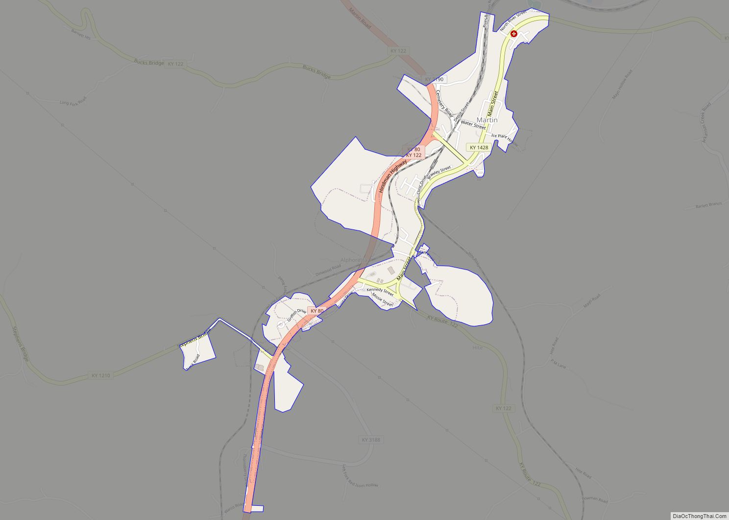
Map of Maryhill Estates city

Map of Maryhill Estates city

Maryhill Estates is a home rule-class city in Jefferson County, Kentucky, United States. The population was 179 as of the 2010 census. Maryhill Estates incorporated in 1963 and was developed in the early 1960s. Developer John A. Walser purchased the land from the Archdiocese of Louisville after World War II and named the development after … Read more

Map of Mayfield city, Kentucky

Map of Mayfield city, Kentucky

Mayfield is a home rule–class city and the county seat of Graves County, Kentucky, United States. The population was 10,017 as of the 2020 United States Census. Mayfield city overview: Name: Mayfield city LSAD Code: 25 LSAD Description: city (suffix) State: Kentucky County: Graves County Incorporated: 1846 Elevation: 476 ft (145 m) Total Area: 7.38 sq mi (19.11 km²) Land … Read more

Map of Massac CDP

Map of Massac CDP

Massac is a census-designated place (CDP) in McCracken County, Kentucky, United States. The population was 4,635 at the 2020 census. It is part of the Paducah, KY-IL Micropolitan Statistical Area. Massac CDP overview: Name: Massac CDP LSAD Code: 57 LSAD Description: CDP (suffix) State: Kentucky County: McCracken County Elevation: 459 ft (140 m) Total Area: 4.07 sq mi (10.54 km²) … Read more

Map of Masonville CDP, Kentucky

Map of Masonville CDP, Kentucky

Masonville is an unincorporated community and census-designated place (CDP) in Daviess County, Kentucky, United States. The population was 1,014 at the 2010 census. It is included in the Owensboro Metropolitan Statistical Area. Masonville CDP overview: Name: Masonville CDP LSAD Code: 57 LSAD Description: CDP (suffix) State: Kentucky County: Daviess County Elevation: 423 ft (129 m) Total Area: … Read more

Map of Maysville city, Kentucky

Map of Maysville city, Kentucky

Maysville is a home rule-class city in Mason County, Kentucky, United States, and is the seat of Mason County. The population was 8,873 as of the 2020 census. Maysville is on the Ohio River, 66 miles (106 km) northeast of Lexington. It is the principal city of the Maysville Micropolitan Statistical Area, which comprises Mason County. … Read more

Map of Mays Lick CDP

Map of Mays Lick CDP

Mays Lick (a.k.a. Mayslick, originally known as May’s Lick) is a census-designated place and unincorporated community in Mason County, Kentucky, United States. As of the 2020 census, it had a population of 252. Mays Lick CDP overview: Name: Mays Lick CDP LSAD Code: 57 LSAD Description: CDP (suffix) State: Kentucky County: Mason County Elevation: 883 ft … Read more

Map of Mayking CDP

Map of Mayking CDP

Mayking is an unincorporated community and census-designated place in Letcher County, Kentucky, United States. Its population was 487 as of the 2010 census. Mayking has a post office with ZIP code 41837, which opened on January 25, 1894. U.S. Route 119 passes through the community. Mayking CDP overview: Name: Mayking CDP LSAD Code: 57 LSAD … Read more

Map of McDowell CDP

Map of McDowell CDP

McDowell is an unincorporated community and census-designated place (CDP) in Floyd County, Kentucky, United States. McDowell CDP overview: Name: McDowell CDP LSAD Code: 57 LSAD Description: CDP (suffix) State: Kentucky County: Floyd County Elevation: 709 ft (216 m) Total Area: 2.48 sq mi (6.42 km²) Land Area: 2.48 sq mi (6.41 km²) Water Area: 0.00 sq mi (0.00 km²) Total Population: 661 Population Density: 266.86/sq mi (103.05/km²) … Read more

Map of McCarr CDP

Map of McCarr CDP

McCarr is an unincorporated community and census-designated places in Pike County, Kentucky, United States. McCarr CDP overview: Name: McCarr CDP LSAD Code: 57 LSAD Description: CDP (suffix) State: Kentucky County: Pike County Elevation: 692 ft (211 m) Total Area: 0.24 sq mi (0.63 km²) Land Area: 0.24 sq mi (0.63 km²) Water Area: 0.00 sq mi (0.00 km²) Total Population: 158 Population Density: 644.90/sq mi (248.99/km²) ZIP … Read more

Map of Maytown CDP, Kentucky

Map of Maytown CDP, Kentucky

Maytown is an unincorporated community and census-designated place in Floyd County, Kentucky, United States. Maytown CDP overview: Name: Maytown CDP LSAD Code: 57 LSAD Description: CDP (suffix) State: Kentucky County: Morgan County Elevation: 909 ft (277 m) Total Area: 0.57 sq mi (1.48 km²) Land Area: 0.57 sq mi (1.48 km²) Water Area: 0.00 sq mi (0.00 km²) Total Population: 227 Population Density: 397.55/sq mi (153.57/km²) FIPS … Read more

Map of McKinney city

Map of McKinney CDP, Kentucky

McKinney is a census-designated place in Lincoln County in south-central Kentucky. McKinney is located along Kentucky Route 198 and the Norfolk Southern Railway, 8.6 miles (13.8 km) southwest of Stanford. McKinney has a post office with ZIP code 40448. Its population was estimated to be 135 between 2014 and 2018. McKinney CDP overview: Name: McKinney CDP … Read more

Map of McKee city

Map of McKee city

McKee is a home rule-class city located in the Commonwealth of Kentucky. It is the seat of Jackson County, KY. As of the 2020 census, the population of the city was 803. The city was founded on April 1, 1882 and was named for Judge George R. McKee. In 2019, the city held a vote … Read more