Map of Blanchard town, Louisiana

Map of Blanchard town, Louisiana

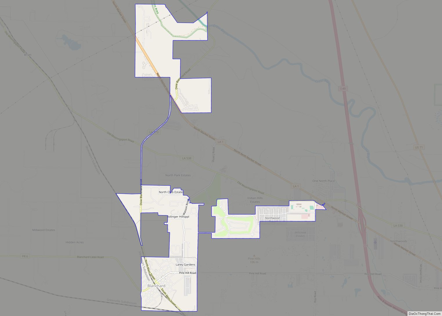
Blanchard is the suburban town in, and the second-largest municipality by population of Caddo Parish in the U.S. state of Louisiana. With a population of 3,538 at the 2020 U.S. census, it is part of the Shreveport–Bossier City metropolitan statistical area. Blanchard town overview: Name: Blanchard town LSAD Code: 43 LSAD Description: town (suffix) State: … Read more

Map of Bossier City city

Map of Bossier City

Bossier City (/ˈboʊʒər/ BOH-zhər) is a city in Bossier Parish in the northwestern region of the U.S. state of Louisiana in the United States. It is the second-most populous city in the Shreveport–Bossier City metropolitan statistical area. In 2020, it had a total population of 62,701, up from 61,315 in 2010. Located on the eastern … Read more

Map of Bordelonville CDP

Map of Bordelonville CDP

Bordelonville is an unincorporated community and census-designated place (CDP) in Avoyelles Parish, Louisiana, United States. As of the 2010 census, it had a population of 525. Bordelonville is located along Bayou des Glaises and Louisiana Highway 451, 17 miles (27 km) east of Marksville, the parish seat. Bordelonville CDP overview: Name: Bordelonville CDP LSAD Code: 57 … Read more

Map of Boothville CDP

Map of Boothville CDP

Boothville is an unincorporated community and census-designated place in Plaquemines Parish, Louisiana, United States. Its population was 854 as of the 2010 census, and 718 at the 2020 U.S. census. Jeré Longman of The New York Times stated that before Hurricane Katrina in 2005 the community served as “a hub of the fishing and oil … Read more

Map of Boyce town

Map of Boyce town, Louisiana

Boyce is a town in northern Rapides Parish, Louisiana, United States. It is part of the Alexandria, Louisiana Metropolitan Statistical Area. The population was 1,004 at the 2010 census. The community is nearly 75 percent African American. Boyce town overview: Name: Boyce town LSAD Code: 43 LSAD Description: town (suffix) State: Louisiana County: Rapides Parish … Read more

Map of Boutte CDP

Map of Boutte CDP

Boutte is a census-designated place (CDP) in St. Charles Parish, Louisiana, United States. The population was 3,075 at the 2010 census, and 3,054 in 2020. Boutte CDP overview: Name: Boutte CDP LSAD Code: 57 LSAD Description: CDP (suffix) State: Louisiana County: St. Charles Parish Elevation: 3 ft (0.9 m) Total Area: 13.84 sq mi (35.85 km²) Land Area: 13.78 sq mi (35.70 km²) … Read more

Map of Bourg CDP

Map of Bourg CDP

Bourg is a census-designated places in Terrebonne Parish, Louisiana, United States. It is part of the Houma–Bayou Cane–Thibodaux Metropolitan Statistical Area. Bourg CDP overview: Name: Bourg CDP LSAD Code: 57 LSAD Description: CDP (suffix) State: Louisiana County: Terrebonne Parish Elevation: 7 ft (2 m) Total Area: 5.74 sq mi (14.87 km²) Land Area: 5.65 sq mi (14.62 km²) Water Area: 0.09 sq mi (0.24 km²) Total … Read more

Map of Bridge City CDP

Map of Bridge City CDP, Louisiana

Bridge City is an unincorporated community and census-designated place (CDP) in Jefferson Parish, Louisiana, United States. It was established in the 1930s during the construction of the Huey P. Long Bridge over the Mississippi River. The town is located on the south side (referred to as the “West Bank”) of the river. It is part … Read more

Map of Breaux Bridge city

Map of Breaux Bridge city

Breaux Bridge (/ˈbroʊˈbrɪdʒ/; French: Pont-Breaux; Cajun French: Pont-(de)-Breaux pronounced [pɔ̃ndbʁo]) is a small city in St. Martin Parish, Louisiana, United States. The population is 8,139 as of the 2010 census, up from 7,281 in 2000. It is part of the Lafayette Metropolitan Statistical Area. Originally dubbed “La Capitale Mondiale de l’Écrevisse,” Breaux Bridge was officially designated … Read more

Map of Branch CDP, Louisiana

Map of Branch CDP, Louisiana

Branch is an unincorporated community and census-designated place in Acadia Parish, Louisiana, United States. As of the 2010 census, it had a population of 388. Branch is located on LA-35 near the LA-365 intersection, approximately 5 miles (8 km) south of the town of Church Point and 8 miles (13 km) north of the city of Rayne. … Read more

Map of Brownsville CDP, Louisiana

Map of Brownsville CDP, Louisiana

Brownsville is an unincorporated community and census-designated place in Ouachita Parish, Louisiana, United States. Its population was 4,317 as of the 2010 census. Brownsville CDP overview: Name: Brownsville CDP LSAD Code: 57 LSAD Description: CDP (suffix) State: Louisiana County: Ouachita Parish Elevation: 79 ft (24 m) Total Area: 3.48 sq mi (9.00 km²) Land Area: 3.48 sq mi (9.00 km²) Water Area: 0.00 sq mi … Read more

Map of Brownfields CDP

Map of Brownfields CDP

Brownfields is an unincorporated area and census-designated place (CDP) in East Baton Rouge Parish, Louisiana, United States. The population was 5,401 at the 2010 census. It is part of the Baton Rouge Metropolitan Statistical Area. Brownfields CDP overview: Name: Brownfields CDP LSAD Code: 57 LSAD Description: CDP (suffix) State: Louisiana County: East Baton Rouge Parish … Read more