Map of Baton Rouge city

Map of Baton Rouge city

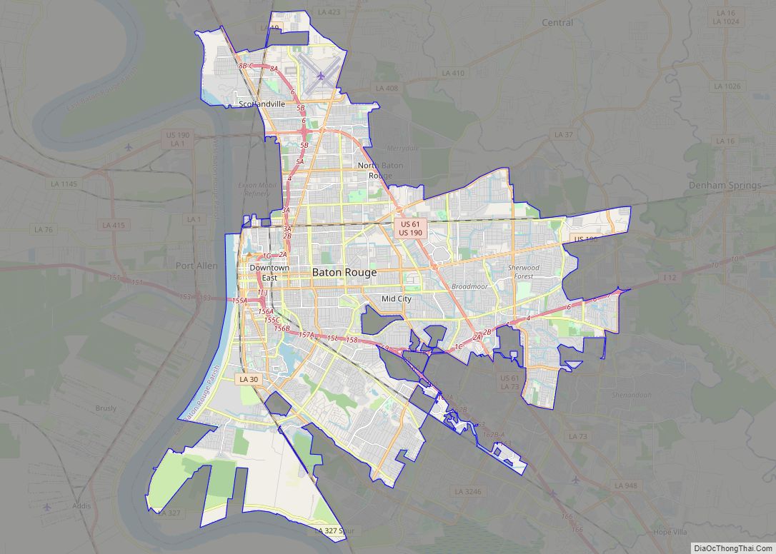
Baton Rouge (/ˌbætən ˈruːʒ/ BAT-ən ROOZH; from French Bâton-Rouge ‘red stick’) is a city in and the capital of the U.S. state of Louisiana. Located on the eastern bank of the Mississippi River, it is the parish seat of East Baton Rouge Parish, Louisiana’s most populous parish—the equivalent of counties in other states. Since 2020, it … Read more

Map of Shreveport city

Map of Shreveport city

Shreveport (/ˈʃriːvpɔːrt/ SHREEV-port) is a city in the U.S. state of Louisiana. It is the third most populous city in Louisiana after New Orleans and Baton Rouge. The Shreveport–Bossier City metropolitan area, with a population of 393,406 in 2020, is the fourth largest in Louisiana, though 2020 census estimates placed its population at 397,590. The … Read more

Map of Lafayette city, Louisiana

Map of Lafayette city, Louisiana

Lafayette (/ˌlæfiːˈɛt, ˌlɑːf-/, French: [lafajɛt]) is a city in the U.S. state of Louisiana, and the most populous city and parish seat of Lafayette Parish, located along the Vermilion River. It is Louisiana’s fourth largest incorporated municipality by population with a 2020 census population of 121,374; the consolidated city-parish’s population was 241,753 in 2020. The Lafayette … Read more

Map of Lake Charles city

Map of Lake Charles city

Lake Charles (French: Lac Charles) is the fifth-largest incorporated city in the U.S. state of Louisiana, and the parish seat of Calcasieu Parish, located on Lake Charles, Prien Lake, and the Calcasieu River. Founded in 1861 in Calcasieu Parish, it is a major industrial, cultural, and educational center in the southwest region of the state. … Read more

Map of Addis town

Map of Addis town

Addis is a town in West Baton Rouge Parish, Louisiana, United States. The population was 3,593 at the 2010 census. It is part of the Baton Rouge Metropolitan Statistical Area. Addis town overview: Name: Addis town LSAD Code: 43 LSAD Description: town (suffix) State: Louisiana County: West Baton Rouge Parish Incorporated: 1915 Elevation: 20 ft (6 m) … Read more

Map of Abita Springs town

Map of Abita Springs town

Abita Springs is a town in St. Tammany Parish, Louisiana, United States. The population was 2,365 at the 2010 census, up from 1,957 in 2000. It is part of the New Orleans–Metairie–Kenner Metropolitan Statistical Area. Abita Springs town overview: Name: Abita Springs town LSAD Code: 43 LSAD Description: town (suffix) State: Louisiana County: St. Tammany … Read more

Map of Abbeville city, Louisiana

Map of Abbeville city, Louisiana

Abbeville is a city in, and the parish seat of, Vermilion Parish, Louisiana, United States, 150 miles (240 km) west of New Orleans and 60 miles (97 km) southwest of Baton Rouge. The population was 12,257 at the 2010 census. At the 2020 population estimates program, the population of the city was 11,927. Abbeville is the principal … Read more

Map of Ama CDP

Map of Ama CDP

Ama is a census-designated place (CDP) in St. Charles Parish, Louisiana, United States. Ama is on the West Bank of the Mississippi River, just west of the Jefferson Parish line. The population was 1,290 at the 2020 census. Ama CDP overview: Name: Ama CDP LSAD Code: 57 LSAD Description: CDP (suffix) State: Louisiana County: St. … Read more

Map of Alexandria city, Louisiana

Map of Alexandria city, Louisiana

Alexandria is the ninth-largest city in the state of Louisiana and is the parish seat of Rapides Parish, Louisiana, United States. It lies on the south bank of the Red River in almost the exact geographic center of the state. It is the principal city of the Alexandria metropolitan area (population 153,922) which encompasses all … Read more

Map of Albany town, Louisiana

Map of Albany town, Louisiana

Albany is a town in eastern Livingston Parish, Louisiana, United States. The population was 1088 at the 2010 census. It is part of the Baton Rouge metropolitan statistical area. District 95 State Representative Sherman Q. Mack, an attorney, resides in Albany. Albany town overview: Name: Albany town LSAD Code: 43 LSAD Description: town (suffix) State: … Read more

Map of Amelia CDP

Map of Amelia CDP, Louisiana

Amelia is a census-designated place (CDP) in St. Mary Parish, Louisiana, United States. The population was 2,459 at the 2010 census. It is part of the Morgan City Micropolitan Statistical Area. Amelia CDP overview: Name: Amelia CDP LSAD Code: 57 LSAD Description: CDP (suffix) State: Louisiana County: St. Mary Parish Elevation: 7 ft (2 m) Total Area: … Read more

Map of Anacoco village

Map of Anacoco village

Anacoco is a village in Vernon Parish, Louisiana, United States. The population was 869 at the 2010 census. It is part of the Fort Polk South Micropolitan Statistical Area. Anacoco village overview: Name: Anacoco village LSAD Code: 47 LSAD Description: village (suffix) State: Louisiana County: Vernon Parish Incorporated: 1979 Elevation: 335 ft (102 m) Total Area: 3.09 sq mi … Read more