Map of Calais city

Map of Calais city

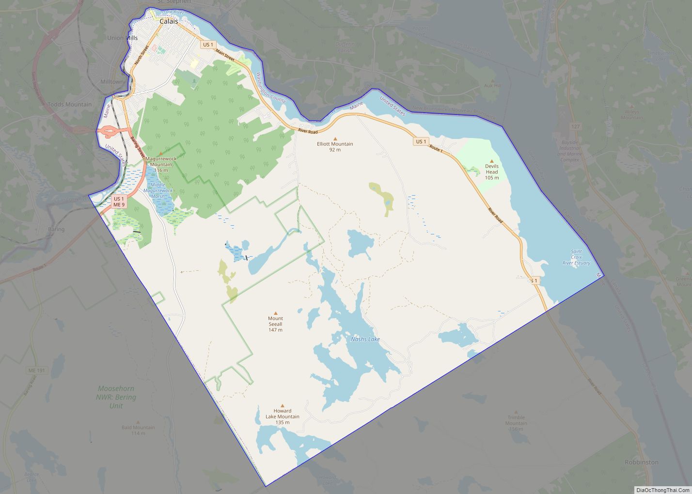
Calais /ˈkælɪs/ is a city in Washington County, Maine, United States. As of the 2020 census, it had a population of 3,079, making Calais the third least-populous city in Maine (after Hallowell and Eastport). The city has three Canada–US border crossings (also known as ports of entry) over the St. Croix River connecting to St. … Read more

Map of Bucksport CDP

Map of Bucksport CDP, Maine

Bucksport is a census-designated place (CDP) in the town of Bucksport in Hancock County, Maine, United States. The population was 2,885 at the 2010 census, down from 2,970 at the 2000 census. Bucksport CDP overview: Name: Bucksport CDP LSAD Code: 57 LSAD Description: CDP (suffix) State: Maine County: Hancock County Elevation: 56 ft (17 m) Total Area: … Read more

Map of Casco CDP

Map of Casco CDP, Maine

Casco is a census-designated place (CDP) in the town of Casco in Cumberland County, Maine, United States. The population of the CDP was 587 at the 2010 census. It is part of the Portland–South Portland–Biddeford, Maine Metropolitan Statistical Area. Casco CDP overview: Name: Casco CDP LSAD Code: 57 LSAD Description: CDP (suffix) State: Maine County: … Read more

Map of Caribou city, Maine

Map of Caribou city, Maine

Caribou is the second largest city in Aroostook County, Maine, United States. Its population was 7,396 at the 2020 census, and between the 2010 and 2020 census it was the fastest-shrinking city in Maine. The city is a service center for the agricultural and tourism industries, and the location of a National Weather Service Forecast … Read more

Map of Cape Neddick CDP

Map of Cape Neddick CDP

Cape Neddick is a census-designated place (CDP) in the town of York in York County, Maine, United States. The population was 2,568 at the 2010 census. It is part of the Portland–South Portland–Biddeford, Maine Metropolitan Statistical Area. Cape Neddick CDP overview: Name: Cape Neddick CDP LSAD Code: 57 LSAD Description: CDP (suffix) State: Maine County: … Read more

Map of Chisholm CDP

Map of Chisholm CDP, Maine

Chisholm is a census-designated place (CDP) in the town of Jay in Franklin County, Maine, United States. The population was 1,380 at the 2010 census. It is an industrial village named for Hugh J. Chisholm, who built the Otis Falls Pulp & Paper Company here in 1888 to use Androscoggin River water power. Chisholm CDP … Read more

Map of Castine CDP

Map of Castine CDP, Maine

Castine is a census-designated place (CDP) in the town of Castine in Hancock County, Maine, United States. The CDP population was 1,029 at the 2010 census, out of 1,366 people in the town as a whole. Castine CDP overview: Name: Castine CDP LSAD Code: 57 LSAD Description: CDP (suffix) State: Maine County: Hancock County Elevation: … Read more

Map of Clinton CDP, Maine

Map of Clinton CDP, Maine

Clinton is a census-designated place (CDP) and the primary village in the town of Clinton in Kennebec County, Maine, United States. The population was 1,419 at the 2010 census, out of 3,486 in the entire town of Clinton. Clinton CDP overview: Name: Clinton CDP LSAD Code: 57 LSAD Description: CDP (suffix) State: Maine County: Kennebec … Read more

Map of Damariscotta CDP

Map of Damariscotta CDP

Damariscotta is a census-designated place (CDP) comprising the main village of the town of Damariscotta in Lincoln County, Maine, United States. The population was 1,142 at the 2010 census, out of 2,218 in the entire town. In the 2000 census, the village was part of the Damariscotta-Newcastle CDP. Damariscotta CDP overview: Name: Damariscotta CDP LSAD … Read more

Map of Cumberland Center CDP

Map of Cumberland Center CDP

Cumberland Center is a census-designated place (CDP) within the town of Cumberland in Cumberland County, Maine, United States. The population was 2,499 at the 2010 census. It is part of the Portland – South Portland – Biddeford, Maine, Metropolitan Statistical Area. Cumberland Center CDP overview: Name: Cumberland Center CDP LSAD Code: 57 LSAD Description: CDP … Read more

Map of Cousins Island CDP

Map of Cousins Island CDP

Cousins Island is an island in Casco Bay within the town of Yarmouth in Cumberland County, Maine, United States. It is listed as a census-designated place, with a population of 490 as of the 2010 census. The CDP is part of the Portland–South Portland–Biddeford, Maine Metropolitan Statistical Area. The island is connected to mainland Yarmouth … Read more

Map of Dover-Foxcroft CDP

Map of Dover-Foxcroft CDP

Dover-Foxcroft is a census-designated place (CDP) in the town of Dover-Foxcroft in Piscataquis County, Maine, United States. The population was 2,592 at the 2000 census. Dover-Foxcroft CDP overview: Name: Dover-Foxcroft CDP LSAD Code: 57 LSAD Description: CDP (suffix) State: Maine County: Piscataquis County Elevation: 361 ft (110 m) Total Area: 8.61 sq mi (22.30 km²) Land Area: 8.38 sq mi (21.71 km²) Water … Read more